
Saint Patrick’s Day Evening Showers

MENTION JOE CIOFFI AND GET A 5% DISCOUNT
We have another in a series of upper air disturbances moving through this evening and this is producing scattered showers and perhaps even a rumble or two of thunder. The air aloft is very cold and very unstable so you may run into a few downpours this evening as these showers work there way through. Keep an eye on the local radars below as not everyone will see showers. On the satellite loop you can see the rotation over the Great Lakes is beginning to move eastward and this will open the door to another chance for scattered showers Friday afternoon. This final disturbance will usher in the arrival of cold air (quite cold given the time of year) for the weekend. It also begins to set us up for the potential for snow here later Sunday and Sunday night.
Saint Patrick’s Day Evening Showers SATELLITE LOOP

Saint Patrick’s Day Evening Showers REGIONAL RADAR LOOP

Both regional and local radars show showers running around and moving eastward. They are impacting temperatures with the cold air aloft. Those temperatures drop when the showers go through by about 10 degrees and then rise back up once the showers are done. Nothing is showing up as exceptional heavy and they are moving fast so just wait a few minutes if you get into one.
Saint Patrick’s Day Evening Showers LOCAL RADAR LOOPS


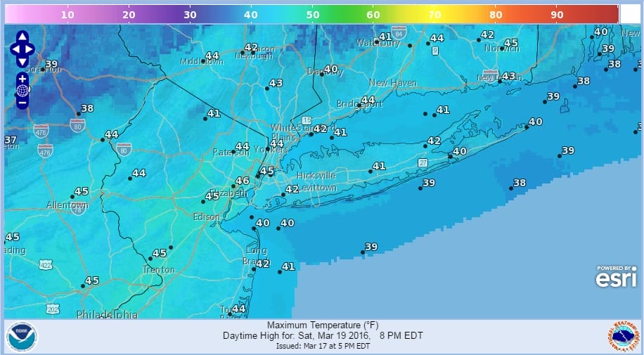
We will do it all over again on Friday as colder air arrives late Friday and for the weekend. Saturday morning lows will be in the 20s to near 30 and highs Saturday just in the 40s.
SATURDAY FORECAST MINIMUM & MAXIMUM TEMPERATURES

Sunday sees the approaching coastal storm and we have more on that with my discussions earlier today regarding the Euro Model and the timing issues brought up by the NAM model.
FiOS1 News Weather Forecast For Long Island
FiOS1 News Weather Forecast For New Jersey
FiOS1 News Weather Forecast For Hudson Valley
NATIONAL WEATHER SERVICE SNOW FORECASTS
LATEST JOESTRADAMUS ON THE LONG RANGE
Weather App

Don’t be without Meteorologist Joe Cioffi’s weather app. It is really a meteorologist app because you get my forecasts and my analysis and not some automated computer generated forecast based on the GFS model. This is why your app forecast changes every 6 hours. It is model driven with no human input at all. It gives you an icon, a temperature and no insight whatsoever.
It is a complete weather app to suit your forecast needs. All the weather information you need is right on your phone. Android or I-phone, use it to keep track of all the latest weather information and forecasts. This weather app is also free of advertising so you don’t have to worry about security issues with your device. An accurate forecast and no worries that your device is being compromised.
Use it in conjunction with my website and my facebook and twitter and you have complete weather coverage of all the latest weather and the long range outlook. The website has been redone and upgraded. Its easy to use and everything is archived so you can see how well Joe does or doesn’t do when it comes to forecasts and outlooks.
Just click on the google play button or the apple store button on the sidebar for my app which is on My Weather Concierge. Download the app for free. Subscribe to my forecasts on an ad free environment for just 99 cents a month.
Get my forecasts in the palm of your hand for less than the cost of a cup of Joe!
![]()
![]()
<


