
Red Flag Fire Risk Today Freeze Watch Overnight Into Thursday Morning Inland

Red Flag Fire Risk Today Freeze Watch Overnight Into Thursday Morning Inland

It is a combination of fire and ice that we see for today. Red flag warnings are up for Southern New Jersey and all of Southern and Central New England. Frankly in my view the fire risk pretty much covers everyone in Eastern Pennsylvania to Southern New England. We are going to see temperatures this afternoon with sunshine and a gusty wind in the 60s and relativel humidity levels in the 20 to 25 percent range and possibly lower area wide so this puts much of the area at brush fire risk.

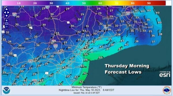
Then we have tonight where under clear skies and diminishing winds, we will see lows inland down near or below freezing. Along the coast most lows will be in the lower 40s and lower temperatures are possible in the pine barrens of Long Island and South Jersey if winds drop off. Further inland we could see temperatures of 32 degrees or less up the Hudson Valley, Southern New England and into Northwest New Jersey and the Catskills.
This is a quick shot of chilly air that builds southward from Eastern Canada. Not only is this very dry air, but it should also be free from the wild fire smoke of Central Canada. The flow in the East is coming straight from the north rather than from the northwest and that is what makes a difference. There are some instability clouds on the satellite in Upstate NY and New England and there could be some clouds in the mix early before many areas go mostly sunny.
SATELLITE

WEATHER RADAR

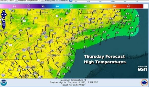
Radars are not an issue today as we will be shower free and no rain is forecast right through Friday. After the cold start Thursday morning, the warm up will not come quickly. High pressure moves offshore just to the east of Long Island and south of Southeastern New England. The return flow is going to be mostly southeast so this will keep highs Thursday in the 60s in spite of what should be a nice sunny day.
Friday we might see temperatures inch up a but in the upper 60s along the coast and lower 70s inland with some sunshine to start but we will probably see some clouds increase from the south later in the day. No rain is forecast until later Friday night into Saturday morning as a weak low develops off the Carolina coast and wobbles northward up the coast.

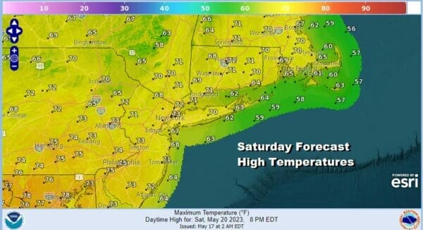
Approaching from the west we have a cold front with some showers. I don’t see this either system being a big deal. The coastal low moves into Southern and Southeastern New England & Long Island with a bit of rain Friday night into Saturday morning. The front to the west looks to have a few showers with that but not much. We may actually see improving weather conditions from west to east later in the day Saturday with highs into the 70s.
Sunday looks to be an even better day with lots of sunshine and warm temperatures. Highs will be in the mid to upper 70s! Next week looks to be dry all week and there is a chance we could carry mostly dry conditions right through the Memorial Day holiday weekend! We will be talking more about this in the coming days.
BE SURE TO DOWNLOAD THE FREE METEOROLOGIST JOE CIOFFI WEATHER APP &
ANGRY BEN’S FREE WEATHER APP “THE ANGRY WEATHERMAN!
MANY THANKS TO TROPICAL TIDBITS FOR THE USE OF MAPS
Please note that with regards to any severe weather, tropical storms, or hurricanes, should a storm be threatening, please consult your local National Weather Service office or your local government officials about what action you should be taking to protect life and property.
(Amazon is an affilate of Meteorologist Joe Cioffi & earns commissions on sales.)


