
Record Highs For Halloween Followed By
Another Shot of Cooler Air Over the Weekend

Record Highs For Halloween Followed By
Another Shot of Cooler Air Over the Weekend
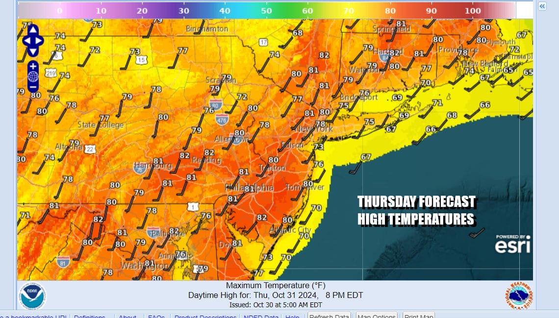
Today is the last day of October and it is Halloween. The month will close out on a very warm sunny note. We will be setting record highs today under sunny skies. Highs will reach the lower 80s over a wide area from Virginia to Southern New England and everyone in between. Even shore locations will get close to 80 degrees before any sea breeze takes hold. Satellite loops show nice clear skies with just some clouds over the Great Lakes and Northern New England. Radars are silent.
SATELLITE WITH LIGHTNING STRIKES

WEATHER RADAR

Tonight will be a warm night with most lows in the 50s inland and lower 60s coast and warmer urban aeras. A cold front is going to be moving through Friday morning but as with the last couple of cold fronts, it will have nothing much with it other than some clouds. Behind the front another cool high builds into the Northeast for the weekend. Then we will transition over to another warm up early next week. Ahead of that warm up will be another warm front that will pass through Sunday night.

There could be a few scattered light showers ahead of the warm front when it goes by Sunday night into Monday morning but we don’t see any widespread rain for all of next week. Another front approaches Wednesday and that front also will be dry. So this leaves us in up and down temperatures and lots of sunny days.
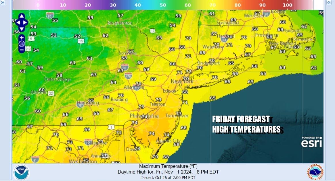
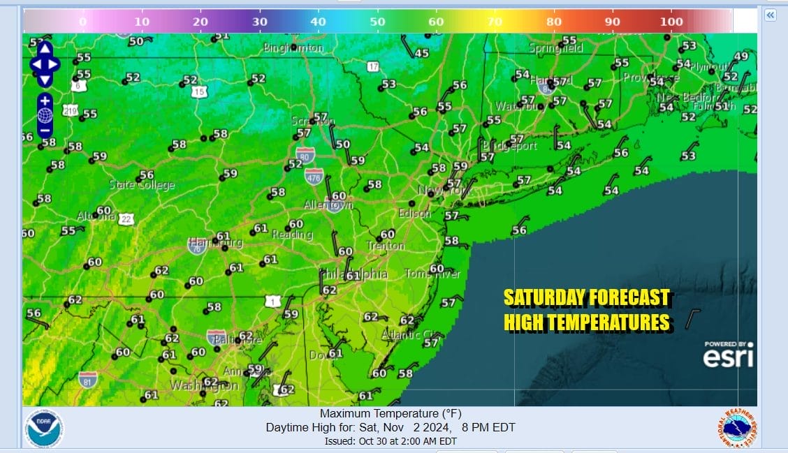
Thought the cold front will be mostly through the area Friday morning there will still be some leftover warm air around. Clouds will give way to some sunshine and winds will shift from southwest to west and then northwest Friday highs will be in the upper 60s and lower 70s. Saturday we see sunshine and a bit if a gustt breeze with highs mostly in the upper 50s to around 60 degrees or so.
We will be cool at night but not especially cold as this new cool air mass doesn’t have any what I would call quality cold air. Nighttime lows will be in the 40s to near 50 with cooler 30s inland. Sunday looks to be mostly sunny though some clouds ahead of the warm front will come in during the afternoon. Highs Sunday will be in the lower 60s except a bit warmer Southern Pennsylvania and Southern New Jersey.

There is nothing in the long range that suggests the pattern of dry rain free weather breaking down. October comes to an end as the driest October on record for many cities from Southern New England to the Northern Mid Atlantic. For some places like New York City for one, this is finishing as the driest month ever in 165 years of records. The old record is .02 inch back in 1949 and this October we have seen .01 inch. I don’t think anyone in Eastern Pennsylvania to Southern New England, Long Island, New Jersey or the Hudson Valley has seen anything more than a few hundreths of an inch of rain since September 29th.
BE SURE TO DOWNLOAD THE FREE METEOROLOGIST JOE CIOFFI WEATHER APP &
ANGRY BEN’S FREE WEATHER APP “THE ANGRY WEATHERMAN!
MANY THANKS TO TROPICAL TIDBITS FOR THE USE OF MAPS
Please note that with regards to any severe weather, tropical storms, or hurricanes, should a storm be threatening, please consult your local National Weather Service office or your local government officials about what action you should be taking to protect life and property.


