
Dry Cool Weekend Another Warm Up Into Wednesday
As No Rain Pattern Continues

Dry Cool Weekend Another Warm Up Into Wednesday
As No Rain Pattern Continues
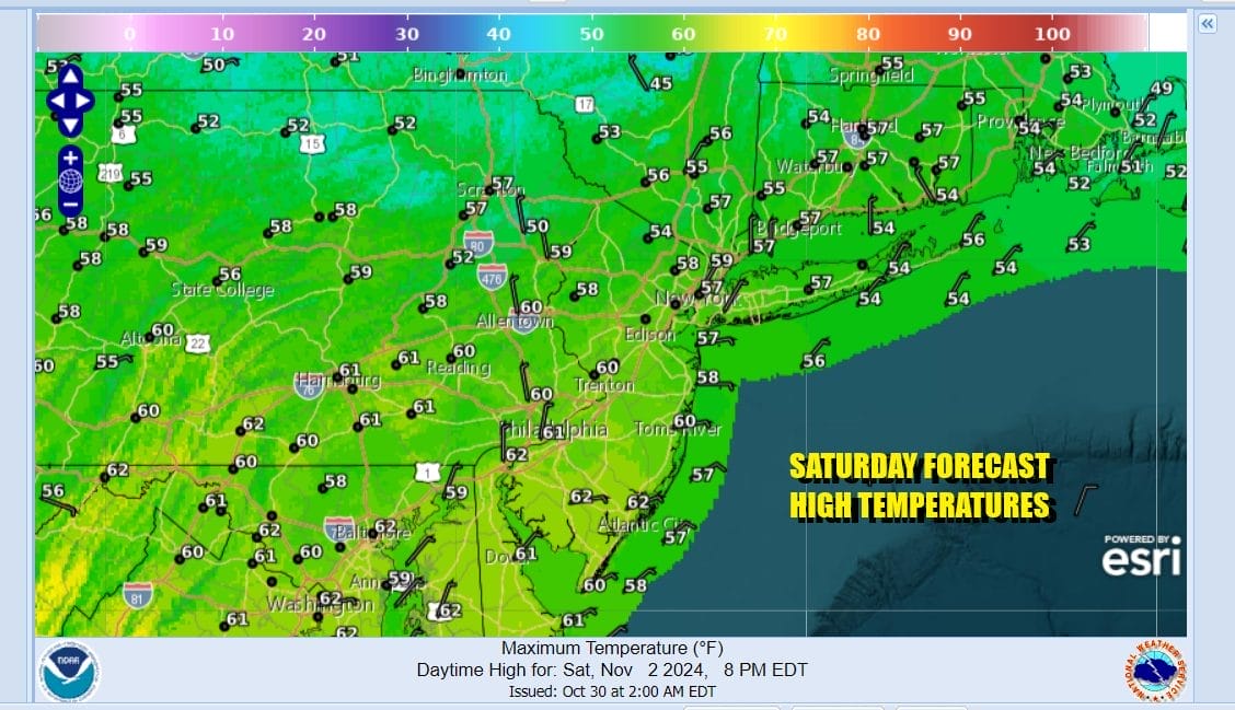
The weekend is here and we have a cooler air mass that has built into the Northeast and Mid Atlantic states. Satellite loops show mainly clear skies. Radars continue their long vacation as there is no widespread rain in sight or even a minor rain event in the cards. Today will be a sunny cool and somewhat breezy day. Temperatures won’t be straying far as highs will generally be in the upper 50s and lower 60s.

Tonight will a nice clear night but it will be a chilly night. There are some areas that have not see their first frosts and freezes but for the most part much of Eastern Pennsylvania to Southern New England has seen its first frosts and freezes. The exceptions are some of the warmer urban areas. Most lows there tonight will be in the lower 40s but areas inland will be in the lower 30s and even some upper 20s by Sunday morning.
SATELLITE WITH LIGHTNING STRIKES

WEATHER RADAR

Sunday is going to be a partly to mostly sunny day as high pressure moves overhead and then eventually heads offshore. We have been in this pattern of 2 to 3 days cool and 2 to 3 days warm with cold fronts in between and that pattern continues this coming week. Highs Sunday afternoon will be in a range of 60 to 65.

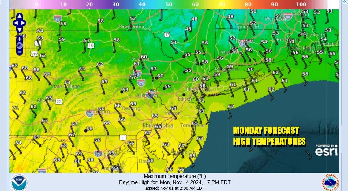
Winds are going to be turning south to southeast later Sunday and Sunday night. A warm front will be setting up nearby and it will likely produce clouds for Monday. Any showers with this warm front will likely be to the north in Upstate NY and Central New England. Monday temperatures will be mostly in the 60s.
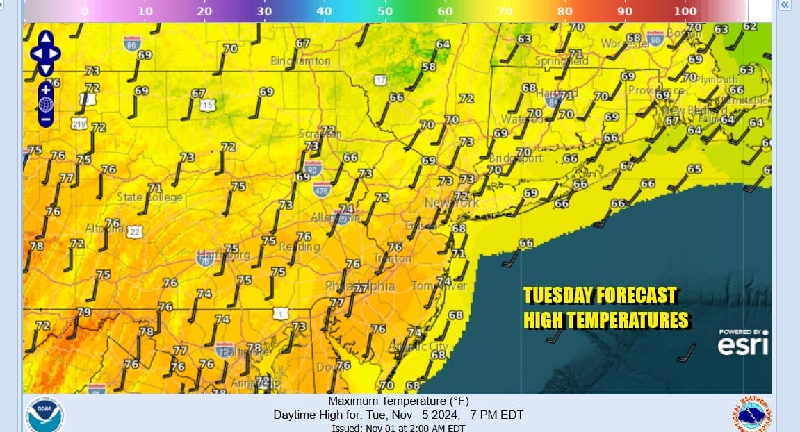
Once again the warm front goes north and temperatures head much higher for Tuesday and Wednesday. It is possible that we could see another round of record or near record highs both for Tuesday and Wednesday which should be days of sunshine and nothing more than a few passing clouds. Tuesday highs will be in the mid to upper 70s and just a little cooler at the coast with local sea breezes.
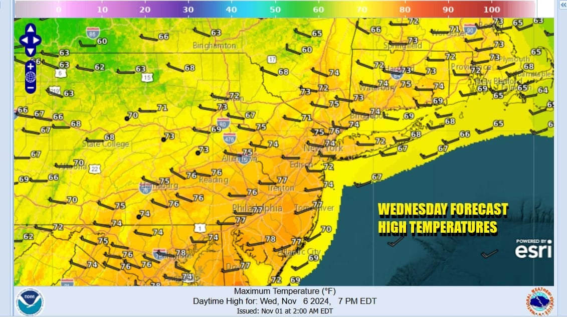
Wednesday brings another cold front that will approach and move through. Once again this weather front will produce showers and thunderstorms in the Midwest and completely fall apart by the time it reaches the East Coast. Wednesday will be no worse than partly sunny with near record highs in the upper 70s to around or just over 80 degrees in some places.
Temperatures will likely trend a little lower for Thursday and Friday with some sunshine returning and highs will be mostly in the mid to upper 60s. There is the chance we could see some rain next weekend as another front approaches from the west. This front will have more legs to it but I wouldn’t exactly bet the farm on a widespread soaking rainfall which is desperately needed.
BE SURE TO DOWNLOAD THE FREE METEOROLOGIST JOE CIOFFI WEATHER APP &
ANGRY BEN’S FREE WEATHER APP “THE ANGRY WEATHERMAN!
MANY THANKS TO TROPICAL TIDBITS FOR THE USE OF MAPS
Please note that with regards to any severe weather, tropical storms, or hurricanes, should a storm be threatening, please consult your local National Weather Service office or your local government officials about what action you should be taking to protect life and property.


