Record Highs For Halloween As Warm Air Surges Northward
No Rain For The Weekend

Record Highs For Halloween As Warm Air Surges Northward
No Rain For The Weekend

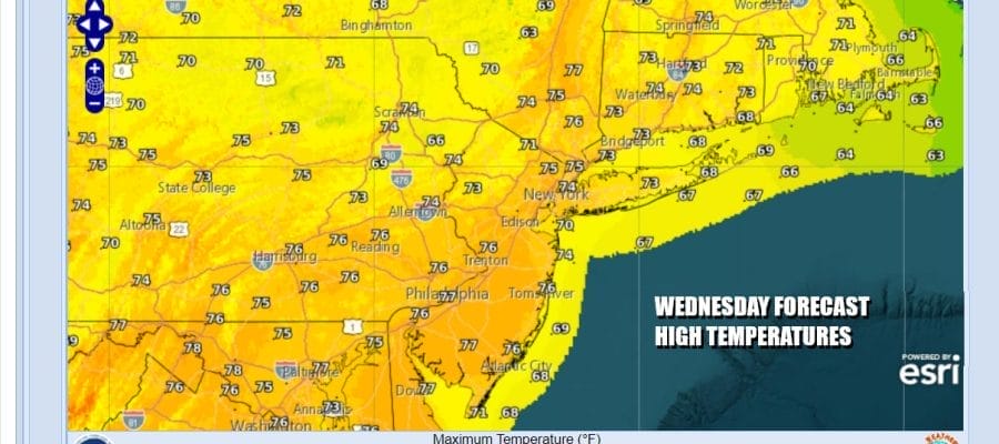
The next round of warming temperatures has begun. A warm front passed last night. Ahead of it yesterday many areas but not all got their first measurable rain in a month ending dry streaks that date back to late September. No rain is forecast for the next 2 days so October will go out as the driest month on record for many locations in Eastern Pennsylvania to Southern New England. Today brings plenty of sunshine and temperatures will reach the mid to upper 70s in most locations except perhaps the shore areas where sea breezes might keep temperatures a few degrees lower.
SATELLITE WITH LIGHTNING STRIKES

WEATHER RADAR

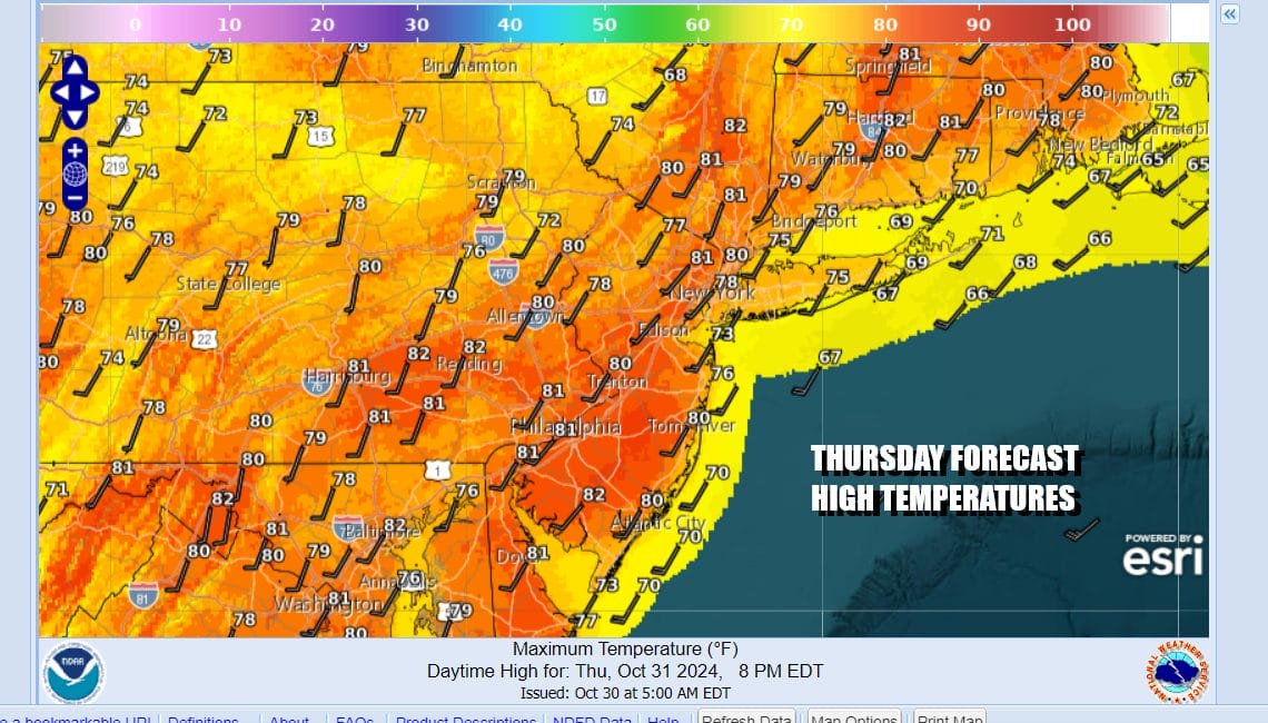
Temperatures will be going nowhere tonight as most lows will be in the mid 50s to lower 60s. Thursday is Halloween and it will be a very warm record breaking day for much of Eastern Pennsylvania to Southern New England. We will have plenty of sunshine and highs will reach the lower 80s over many locations.
Low pressure is heading for the Northern Great Lakes today and ahead of this front we will see showers and thunderstorms from Texas to Wisconsin including much of the Mississippi and Missouri River Valley. Widespread severe weather and tornado risk is forecast for this zone especially in Eastern Kansas and Missouri where tornado risk is elevated.

The strong ridge of high pressure aloft in the Southeast US remains strong and as the front moves east it will weaken. By the time it reaches the East Coast most of the showers and thunderstorms will disappear. Other than clouds tonight into Friday morning, and the chance for a brief shower, the front passes with nothing more than a wind shift to the northwest.
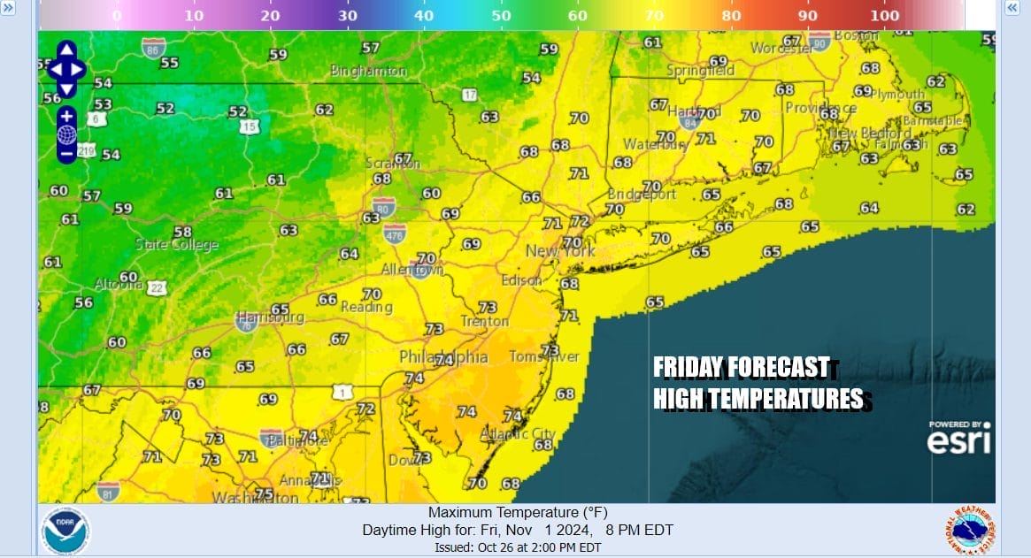
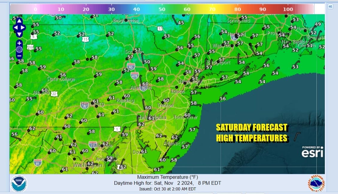
This leaves us with clouds in the morning Friday followed by some developing sunshine in the afternoon. Leftover warm air will allow temperatures to reach the upper 60s and lower 70s for highs. Then cooler air comes in Friday night and that leaves us with a dry but coolish weekend. Saturday we will see sunshine and high temperatures will be in the upper 50s and lower 60s.
This cool air mass comes in and begins to exit Sunday. There is another warm front that will approach Sunday from the west as we set up for another round of warmer temperatures for early next week. Ahead of the front Sunday we will have sunny skies though some clouds could move in later in the day. Highs Sunday will reach the lower to a few middle 60s with the warmer temperatures South Jersey and Southern Pennsylvania southward.

The warm front could struggle a bit to get through Sunday night and Monday so we expect lots of clouds especially from Northern New Jersey NYC and Long Island north and east and there might be some showers in the mix. Temperatures will be in the 60s except lower 70s South Jersey and Southern Pennsylvania southward. Tuesday and Wednesday of next week look to be warm with highs in the 70s before another dry cold front approaches mid week. No widespread rain is forecast anytime soon.
BE SURE TO DOWNLOAD THE FREE METEOROLOGIST JOE CIOFFI WEATHER APP &
ANGRY BEN’S FREE WEATHER APP “THE ANGRY WEATHERMAN!
MANY THANKS TO TROPICAL TIDBITS FOR THE USE OF MAPS
Please note that with regards to any severe weather, tropical storms, or hurricanes, should a storm be threatening, please consult your local National Weather Service office or your local government officials about what action you should be taking to protect life and property.


