Record Highs As Maria Moves Northward

Record Highs As Maria Moves Northward
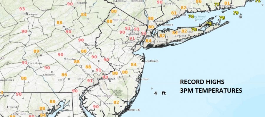
While Hurricane Marie continues its march northward off the US Southeast Coast we continue to see very warm conditions across the Northeast. Temperatures are down right hot in some places with 3pm readings close to 90 degrees with records falling in a few places like New York City, & Islip on Long Island. Temperatures at least so far in Southeastern Pennsylvania and in Southern New England have not broken any records yet.
SATELLITE LOOP

The satellite loop shows how the jet stream is so far to the north. Clouds are moving west to east across Southern Canada and south to north across the Western Plains. Everywhere to the east of that is the big upper high that is creating the unusually warm conditions. Hurricane Maria of course sits underneath that upper and and another one to its east. Actually if you look to the far right about midway up is a very tiny Hurricane Lee which is drifting northward and poses no threat to land. Maria looks almost 10 times as large.
REGIONAL RADAR

LOCAL RADAR NEW YORK CITY

LOCAL RADAR PHILADELPHIA


We have 3 more days of this although today could turn out to be the hottest day of the stretch. A cold front will move through Thursday and we should cool down considerably at the end of the week and next weekend. That front will be helping to steer Maria out to sea and it is not threat to the Northeast. Maria will likely make a close pass to the Outer Banks of North Carolina Tuesday into Wednesday where tropical storm conditions are possible. The core of the hurricane should stay offshore. We will have a complete rundown on Hurricane Maria later this evening.
 GET JOE A CIGAR IF YOU LIKE

FiOS1 News Weather Forecast For Long Island
FiOS1 News Weather Forecast For New Jersey
FiOS1 News Weather Forecast For Hudson Valley


