Rain Winding Down Ocean Storm Moves Away Saturday Minor Coastal Flooding Tonight
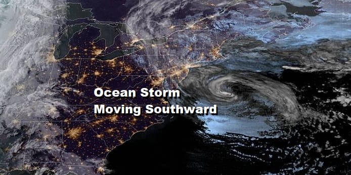
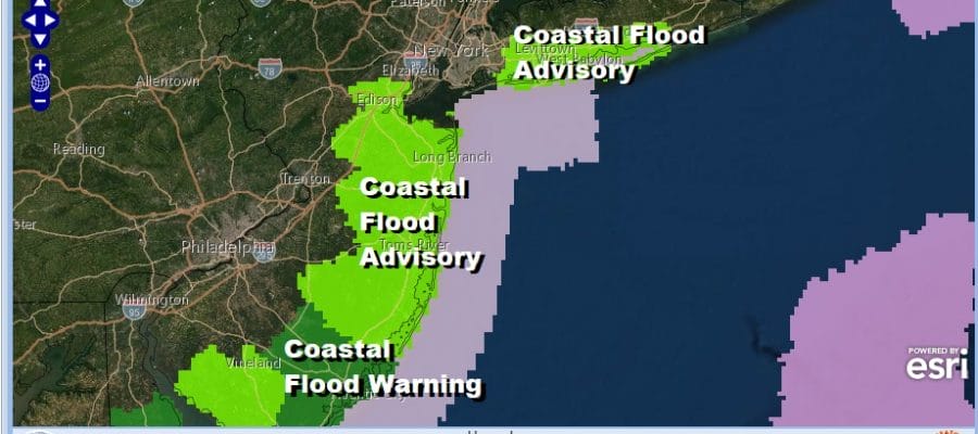
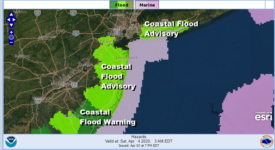
Our ocean storm kept much of the area from New Jersey to New England in clouds and rain today though the rain was on and off. The storm is kicking up the surf enough and the west track is piling some water onto the coastline. Coastal Flood Advisories and Warnings are up for parts of Long Island as well as the New Jersey shore with a coastal flood warning for the South Jersey shore overnight into Saturday. Minor coastal flooding is forecast except in the warning area where moderate coastal flooding is expected at high tide.
Areas well inland today experienced nothing but clouds and now we watch as the storm moves southward overnight and then southeast and east during the day Saturday. This will keep clouds around into Saturday morning but with a little luck we should see some sunshine break through the clouds. Temperatures tonight will be in the 40s and highs Saturday will be mostly in the 50s depending on how much sun you get.
SATELLITE

REGIONAL RADAR

Regional and local radars are still picking up bands of showers but the bands are weakening as they move southwestward. You can see the spotty nature on the local radars. The rain is mostly light and should wind down overnight.
LOCAL RADAR NEW YORK CITY

LOCAL RADAR PHILADELPHIA


There is a weather system moving eastward across the Great Lakes and it will be weakening as it approaches here on Sunday. There will be some clouds with this but I think we should see some sunshine break through the clouds. This should send temperatures up into the 60s away from the ocean Sunday afternoon.

Monday should be a nice day with sunshine and highs in the 60s. Next week brings some weak weather systems along Tuesday and Wednesday with minor shower chances. We could be setting up for something stronger late next week or next week. The GFS model is showing a major storm coming out of the Plains and heading into the east late next week while the European model shows something coming next weekend. The blocky pattern continues which makes things tenuous in the long range so we will be looking at this with interest over the weekend.
BE SURE TO DOWNLOAD THE FREE METEOROLOGIST JOE CIOFFI WEATHER APP &
ANGRY BEN’S FREE WEATHER APP “THE ANGRY WEATHERMAN!
MANY THANKS TO TROPICAL TIDBITS FOR THE USE OF MAPS
Please note that with regards to any severe weather, tropical storms, or hurricanes, should a storm be threatening, please consult your local National Weather Service office or your local government officials about what action you should be taking to protect life and property.


