Rain & Storm Free Weather Next 2 Days But
Severe Weather & Flooding Risks Back Late Week

Rain & Storm Free Weather Next 2 Days But
Severe Weather & Flooding Risks Back Late Week

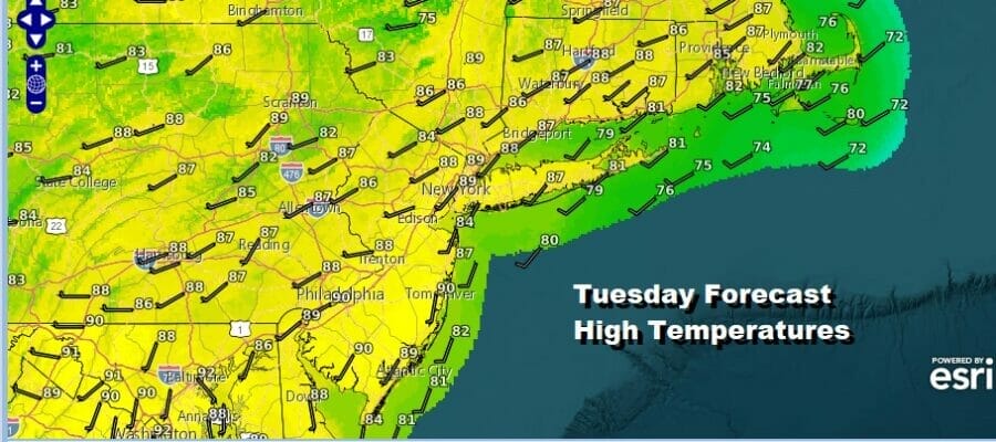
After the orderal of Sunday and Sunday night it is time for a little bit of a break for the Northeast. Low pressure is in Northern Vermont and moving northward. That is helping to funnel dry air into the rest of the Northeast and Middle Atlantic states. Humidity levels are not all that high today as dew points have dropped to the upper 50s and lower 60s so it should be comfortable. At least compared to dew points in the 70s, this is downright delightful. Sunshine will take highs to the upper 80s to near 90 degrees in most areas and it will be a little cooler at the shore. Other than an isolated shower or thunderstorm, it is a rain free day for 99.9 percent of you.
SATELLITE WITH LIGHTNING STRIKES

WEATHER RADAR

Wednesday morning lows will be in the mid 60s to lower 70s under mainly clear skies. Wednesday is going to be a hot day. Dew points will nudge up a little but it won’t be terrible humidity wise. Again there is only the outside chance for an isolated shower or thunderstorm. Otherwise it is another rain free day with sunshine. Highs Wednesday will reach the upper 80s and lower 90s.

Moving along this week, we are still in a pattern where the jet stream from Canada creates a northwest flow into the Great Lakes and Ohio Valley and then it turns southwest in the Northeast. This keeps weather systems moving along in the flow on a regular basis. The next round of short wave upper troughs and cold fronts will begin to move through late week and over the weekend.

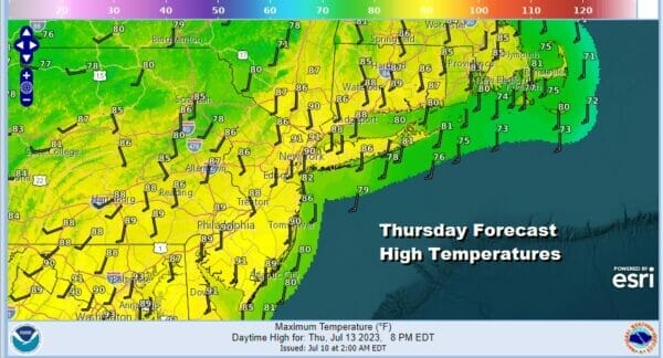
A warm front will be moving through Thursday morning and there could be a shower or thunderstorm with that as it goes by. This will usher in higher dew points and a return to very humid conditions. Thursday we will see some sunshine take high temperatures into the upper 80s and lower 90s.
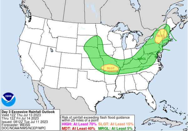
The atmosphere will be somewhat unstable and coupled with the high humidity we could see some thunderstorms running around during Thursday afternoon and evening. The Storm Prediction Center is indicating a marginal risk for severe weather which means that there is the chance for some isolated severe thundertorms.. Also any thunderstorms that cause heavy rains will likely mean there is risk for localized flash flooding given the saturated ground from Sunday’s rains. The Weather Prediction Center indicates a marginal risk for flash flooding over the Northeast and Mid Atlantic states.
We are likely to see very warm and humid conditions Friday and through the weekend with the risk for afternoon and evening downpours and thunderstorms. Temperatures will likely be in the mid 80s to near 90 by day and upper 60s to mid 70s by night. Weather fronts will be slow to move through but we do not see a repeat performance of the widespread rains of Sunday.
BE SURE TO DOWNLOAD THE FREE METEOROLOGIST JOE CIOFFI WEATHER APP &
ANGRY BEN’S FREE WEATHER APP “THE ANGRY WEATHERMAN!
MANY THANKS TO TROPICAL TIDBITS FOR THE USE OF MAPS
Please note that with regards to any severe weather, tropical storms, or hurricanes, should a storm be threatening, please consult your local National Weather Service office or your local government officials about what action you should be taking to protect life and property.
(Amazon is an affilate of Meteorologist Joe Cioffi & earns commissions on sales.)


