
Thunderstorms Severe Weather & Flash Flood Risk Grow
Northeast Mid Atlantic Thursday Through Sunday
We are setting up for the growing risk for downpours and thunderstorms in the coming days. Friday and Sunday look to offer the highest chances for downpours and thunderstorms along with risks for severe weather. This will impact areas of the Northeast and Coastal Mid Atlantic states. This is coming on the heels of Sunday’s devastating rainfalls in this area. The risks for additional flash flooding are definitely rising. More on this in a moment.

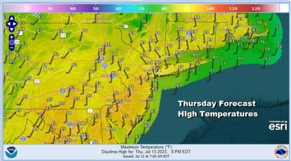
Today is another day of sunshine across the Northeast and Mid Atlantic states. Other than a few passing clouds there are no real issues. Humidity levels today are going to creep up slightly from yesterday but it should not be unreasonable outside from that standpoint. Temperatures this afternoon will reach the upper 80s to lower 90s just about everywhere except along the shore where it will be a little cooler this afternoon and a good place to be for a little relief. Well inland (north of Route 84) there is the small risk for an isolated shower or thunderstorm late this afternoon and evening but for the vast majority it is a rain free day.
SATELLITE WITH LIGHTNING STRIKES

WEATHER RADAR

We will begin to see changes over the coming days that will lead to a return to higher humidity, and the chance for thunderstorms. The risk for storms starts out on the low side for Thursday but gradually as we move through the weekend we will see the risks for thunderstorms and severe weather grow.

An unusually strong upper low sits in South Central Canada and it has been there for the better part of a week. It is blocked from moving eastward for now so short wave troughs will be rotating around this upper low and as each one goes by, it will bring a weather front close to the East Coast. The problem is that these fronts have no push to move much further east once they arrive so they will result in the increasing risk for thunderstorms.

The return of the southwest flow means the return of high dew points so get ready to be uncomfortable. Dew points Thursday will rise into the upper 60s and lower 70s and as the first in a series of weather fronts approach, this one dropping south from upstate NY, we could see some scattered thunderstorms Thursday afternoon and evening. Ahead of that sunshine will take highs up into the low and middle 90s in many locations.
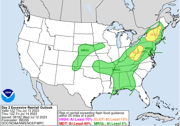
The thunderstorm risk Thursday will be a little more wide spread but the best chances lie north and west of the coast. We are at a place right now where saturated grounds mean that even a short duration thunderstorm if it is slow moving could trigger off flash flloding. The Weather Prediction Center is indicating the risk for flash flooding exists in the Northeast and Mid Atlantic states westward into the Ohio Valley.
With the first system laying along the coast Friday we see a better chance for rain and thunderstorms developing in a very warm and very humid air mass. Dew points will be rising into the low and middle 70s saturating the air and with daytime heating thundertorms are more likely and more widespread during the afternoon and evening.
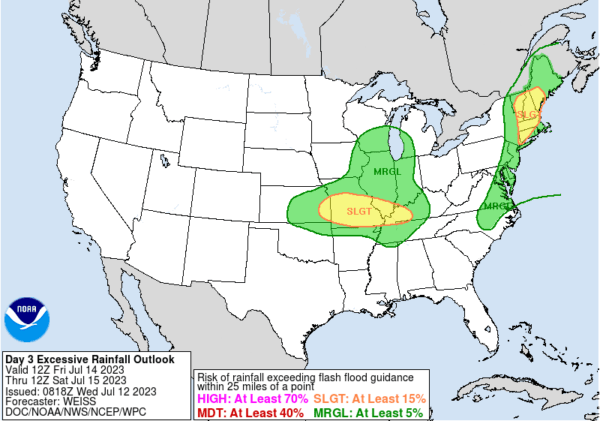
Again we see the risk for excessive rainfall and flash flooding from the Mid Atlantic northeast through New England. Highs Friday will be mostly in the 80s. We also have the risk for severe weather Friday and the Storm Prediction Center opens the door for a marginal risk of isolated severe thundertorms from Southern New England south to the Mid Atlantic coast.

Saturday we could catch a bit of break but it will be a hot humid day with scattered thunderstorms and highs back into the 90s. However we do see a stronger system coming for Sunday and we could be in the throws of another system that might produce excessive rainfalls and flash flood risk.
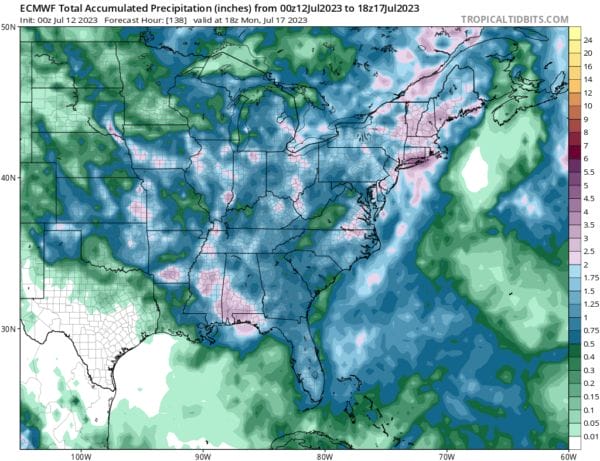
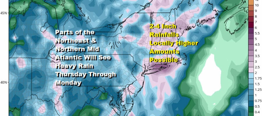
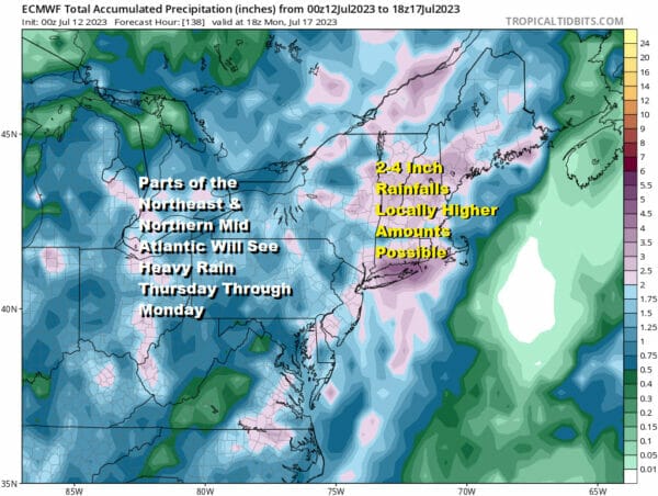
Weather models are rather bullish on rainfall amounts over the Thursday Through Monday morning timeframe with models showing 1-3/2-4 inch rainfalls over the next 7 days. Given the convective nature of these systems and the amount of tropical air, local amounts could be double the model forecasts like we just saw in last Sunday’s system. This one does seem to move along a bit faster but we need to monitor the situation carefully. The Northeast and Northern Mid Atlantic need to monitor weather forecasts in the coming days to the the excessive rainfall possibilites and flash flood potential.
BE SURE TO DOWNLOAD THE FREE METEOROLOGIST JOE CIOFFI WEATHER APP &
ANGRY BEN’S FREE WEATHER APP “THE ANGRY WEATHERMAN!
MANY THANKS TO TROPICAL TIDBITS FOR THE USE OF MAPS
Please note that with regards to any severe weather, tropical storms, or hurricanes, should a storm be threatening, please consult your local National Weather Service office or your local government officials about what action you should be taking to protect life and property.
(Amazon is an affilate of Meteorologist Joe Cioffi & earns commissions on sales.)


