
Rain Sinks Southward Today But Comes Back Saturday
Improving Weather Sunday

The weekend is upon is and the better of the 2 weekend days will be Sunday without question. Getting there we are in a gloom and doom scenario with lots of clouds that are streaming in from the west. There is a cold front that is pushing southward and a band of rain from Pennsylvania to just south of NYC on the radar. Gradually this rain area will shift southward and weaken as the day wears on. When you put it all together it is a not so nice Friday with highs just into the 50s.
SATELLITE

WEATHER RADAR

We may actually go dry for a little while tonight and then low pressure developing in the Lower Mississippi Valley makes its move toward Michigan and the low will be strengthening along the way. Today’s cold front stalls across Virginia and then begins to move back northward as a warm front Saturday. We will see cloudy skies overnight with temperatures in the 40s.
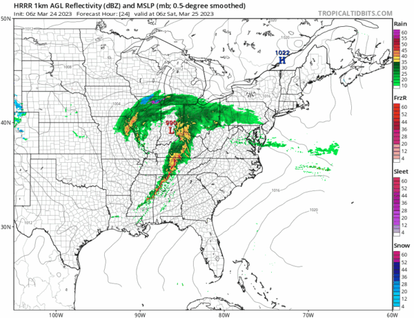
Most areas will see some rain by daybreak and in areas north of Route 84 in the Hudson Valley and Conneciticut there could be some snow and sleet at the start briefly. Otherwise Saturday is a raw rainy day for most folks but where the warm front winds up will determine this.
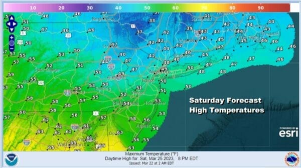
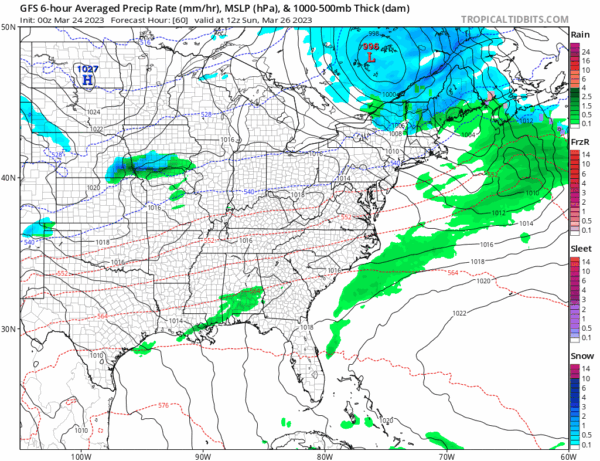
Most of the area will see temperatures not get out of the 40s. Southern New Jersey, Southern Pennsylvania and points southward have a chance to get into the 50s. Rain will come to an end from west to east during the mid to late afternoon as the low moves into Southeastern Canada and a cold front passes offshore.
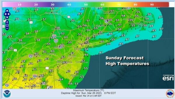
There isn’t any cold air behind this front so with sunshine coming back Sunday, it will actually be warmer than Saturday. It might get a little breezy at times but nothing crazy regarding the wind. Highs will be in the rather nice (for spring) lower 60s in most places.
Weather systems seem to be moving along in rapid succession. The next low will be on our doorstep Tuesday as it heads across the Ohio Valley and then redevelops offshore. Monday should be dry with some sun and highs in the 50s. Tuesday clouds increase and there could be some rain later Tuesday into early Wednesday depending on the exact timing of this system. There might also be the chance for some snow well inland but this doesn’t appear to be any big deal at this point. Once this system goes by the rest of the week will be dry and on the chilly side with another chance for some rain late next Friday into Saturday.
BE SURE TO DOWNLOAD THE FREE METEOROLOGIST JOE CIOFFI WEATHER APP &
ANGRY BEN’S FREE WEATHER APP “THE ANGRY WEATHERMAN!
MANY THANKS TO TROPICAL TIDBITS & F5 WEATHER FOR THE USE OF MAPS
Please note that with regards to any severe weather, tropical storms, or hurricanes, should a storm be threatening, please consult your local National Weather Service office or your local government officials about what action you should be taking to protect life and property.


