Rain Arriving Heavy Overnight into Saturday Morning
We are beginning to see the radars expand as clouds continue to push northward into New England. Rain is expanding just in time for the evening commute and there will be some heavy rains overnight up and down the coastal plain. 1 to 2 inches of rain seems likely for most areas and I would not be at all to see some localize flooding from all this. Temperatures have been rising and have reached the 40s in most coastal areas. Some 50s are showing up on Long island and Southern New Jersey with 30s well inland in Northwest New Jersey, the Hudson Valley and Connecticut.
SATELLITE

REGIONAL RADAR

We are seeing that wall of rain pushing into the Catskills and to areas north of NYC. Heavier rains on the regional radar are still down in Southern Virginia and North Carolina but that will be moving northward tonight. It won’t be fun for the evening commute with all this rain around. Areas in Central and Northern New England and in parts of Eastern NY are seeing Winter Weather Advisories for a light glaze possible this evening until temps can break above 32.
LOCAL RADAR NEW YORK CITY

LOCAL RADAR PHILADELPHIA


There is no change in the logic or the outcome of what is going to happen overnight and on Saturday. Heavy rains overnight will be ending tomorrow morning from south to north. Weather conditions will be very slow to improve until this storm moves northward later in the day in upstate NY. After that the winds from the northwest kick in to 20 to 30 mph with higher gusts and skies should start to clear out Saturday night.

Temperatures will reach the 50s on Saturday but they will ease on Sunday as colder air comes in on those gusty northwest winds. Most highs will settle in the 40s and we should be down in the 20s to near 30 by Monday morning.
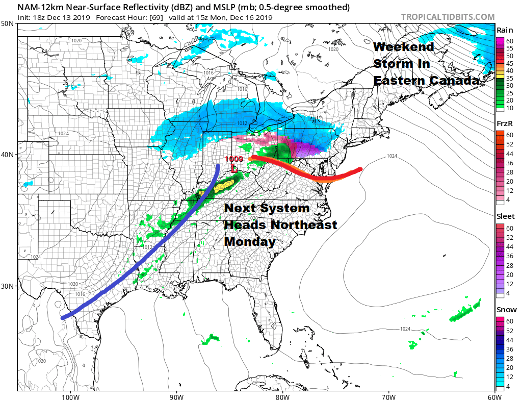
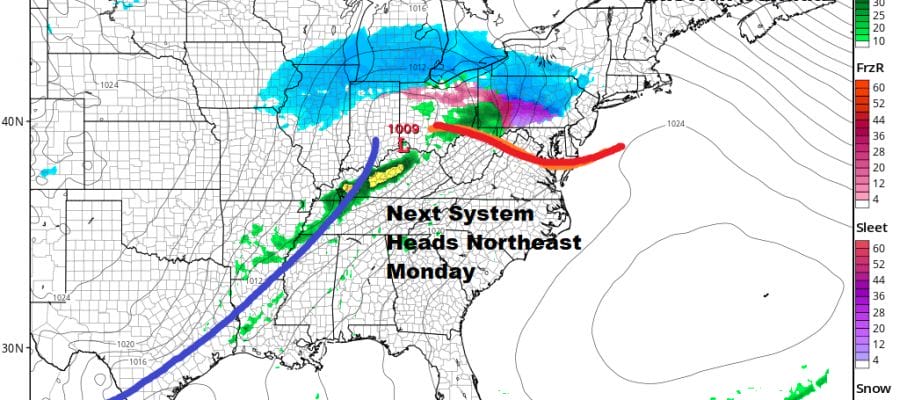
By Monday morning we will be clouding up rather quickly because the next weather system will be moving east out of the Southern Plains. Low pressure will head for West Virginia and attempt to redevelop along the coast. This makes for a bit of a dicey forecast regarding snow to ice to rain here Monday and Monday night. Tonight’s storm system is going to be one of the keys to whether we get a quick change to sleet and rain or a more prolonged period of snow and ice especially inland. We have more on this on our weather platform on Patreon
BE SURE TO DOWNLOAD THE FREE METEOROLOGIST JOE CIOFFI WEATHER APP &
ANGRY BEN’S FREE WEATHER APP “THE ANGRY WEATHERMAN!
MANY THANKS TO TROPICAL TIDBITS FOR THE USE OF MAPS
Please note that with regards to any severe weather, tropical storms, or hurricanes, should a storm be threatening, please consult your local National Weather Service office or your local government officials about what action you should be taking to protect life and property.


