
RAIN ARRIVES TONIGHT ENDS TUESDAY MORNING
COLD BUT DRY WEDNESDAY INTO THURSDAY
NEXT STORM ARRIVES THURSDAY, SNOW SLEET THREAT INLAND ELEVATED AREAS
Clouds are continuing to increase across the area and we are watching rain advancing northeastward through the Middle Atlantic States. We should not have any issues rain wise through this evening which makes the holiday commute such as it is relatively easy. Rain should start spreading rapidly northward later this evening and tonight and it should be raining just about everywhere from Southeastern Pennsylvania to Southern New England by midnight.
EASTERN SATELLITE

REGIONAL RADAR

Regional radar shows a large area of rain advancing northeastward through North Carolina, Virginia, and West Virginia. Some embedded areas of moderate to heavy rain are showing up at the moment at least. We think that 3/4 inch to 1.25 inch of rain seems reasonable here.
LOCAL RADAR NEW YORK CITY

LOCAL RADAR PHILADELPHIA


This weather system moves along Tuesday and the rains will end from south to north during tomorrow morning with leftover clouds in the afternoon. Temperatures overnight will hold in the upper 30s to lower 40s and then peak in the 50s Tuesday. Cold air from a cold high will arrive for Wednesday. We look for sunshine but a cold north wind will keep temperatures just in the low to mid 40s at best. By Thursday morning lows everywhere will be in the 20s to lower 30s.
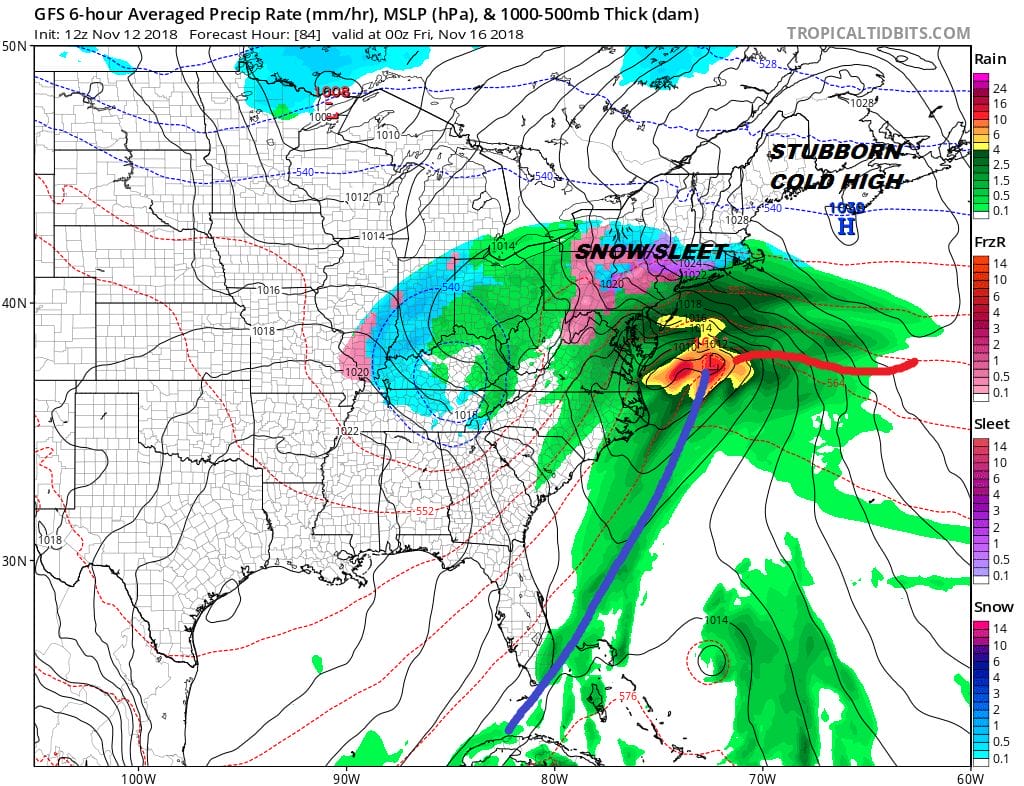
Low pressure Thursday moves up the coast coupled with a strong upper trough in the Central Appalachians. Cold air from a cold high to the northeast will be pressing in at least for awhile. That plus the strength of that upper trough is likely to cool down the atmosphere enough that we could see the first snow/sleet of the season. Forecasting the first snowfall is almost always a religious experience and it is made even tougher because we are in mid November and not mid December. It would seem at this point that elevated areas north and west of Philadelphia & NYC could see some snow or sleet out of this and certainly an argument can be made that mixing could occur at least for awhile along coastal areas as well. The European model oddly enough seems to be the most bullish on this prospect which caught our attention today. The interior of Northern Pennsylvania, upstate NY & New England seem to stand a solid chance of seeing accumulating snow from this.
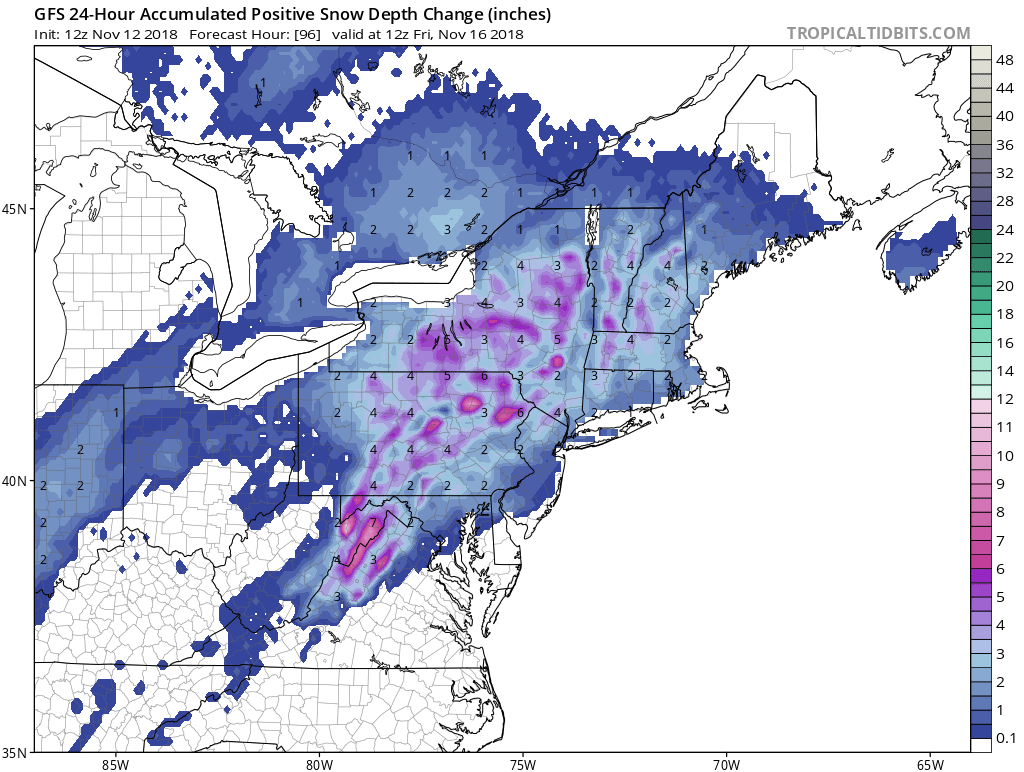
This also begins another season of looking at snow forecast maps which always take us on wild rides. The map above shows the 24 hour snow/sleet snowfall ending Friday morning. Rather than focus on the specific numbers because they will change, the GFS and also the European support the idea of some mixing for coastal areas and some elevation driven accumulation inland. It is early. We want to see more before committing on this in one direction or another.
As far as snow for tonight is concerned it is mainly confined to areas well north and northeast. The updated snow forecast maps are posted.
SUBSCRIBE TO PATREON FOR A WEATHER EXPERIENCE FREE OF ADS, EXCLUSIVE VIDEOS FOR MEMBERS ONLY AND MUCH MORE…STARTS AT $2 A MONTH..MESSAGE ME AT ANY TIME

MANY THANKS TO TROPICAL TIDBITS FOR THE USE OF MAPS
Please note that with regards to any tropical storms or hurricanes, should a storm be threatening, please consult your local National Weather Service office or your local government officials about what action you should be taking to protect life and property.
LATEST JOESTRADAMUS ON THE LONG RANGE

