Quiet Weather Week Ahead No Major Storms Seasonal Temperatures

Quiet Weather Week Ahead No Major Storms Seasonal Temperatures
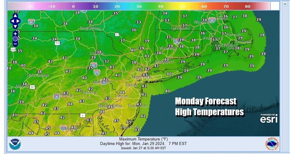
We are seeing the Sunday storm system offshore beginning to move away to the east northeast and that should set the stage for some slow improvement but we do mean snow. There is some light leftover precipitation around on the radar but that should move out by midday and we see leftover clouds and maybe, just maybe, brightening of skies during this afternoon. Temperatures are going to hold in the chilly upper 30s and lower 40s for much of the day. There still might be some leftover clouds around tonight and Eastern Pennsylvania to Southern New England lows will be in the 20s to around 30 degrees.
SATELLITE WITH LIGHTNING STRIKES

WEATHER RADAR

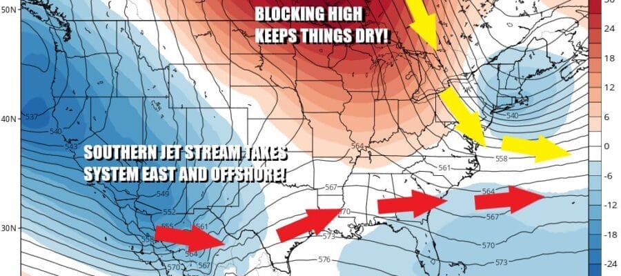
While this may a precipitation free week (after today) it will not necessarily be a cloud free week. We have an upper air disturbance over the Western Great Lakes that will be diving southeastward. This system dives so far southeastward that it actually emerges off the coast of the Carolains and then continues eastward from there toward Bermuda! The upper flow is strong northwest across the Great Lakes and Northeast and that effectively squashes any weather system from moving northward.

This leaves in a place of near seasonal conditions. Tuesday we should see some sunshine with patchy clouds around. Highs will be mostly in the mid 30s to around 40. Wednesday again should be a day of clouds and sun with highs in the upper 30s and lower 40s. Thursday we have a cold front that is dropping southward from Eastern Canada and ahead of it we will see some sun and arriving clouds with highs in the 40s. Thursday night into early Friday there could be a few showers. Behind the front is a shot of colder air but models have backed off on the magnitude of the colder air for later Friday and through the weekend. We do know it will be dry after the front passes and we will go with temperatures being on the cold side of normal through the weekend.
 Over the weekend we will see a strong low pressure area developing in Texas and given the upper air weather pattern, that storm is forecast to move eastward across the Deep South and then off the Southeast coast of the US. Right now thanks to the northwest flow across Eastern Canada and the Northeast it is hard to imagine this system coming up the East Coast at least from what we are seeing in models right now. This however could be a rather wet (and in some cases white) weather system for the Deep South and Southeast US early next week.
BE SURE TO DOWNLOAD THE FREE METEOROLOGIST JOE CIOFFI WEATHER APP &
ANGRY BEN’S FREE WEATHER APP “THE ANGRY WEATHERMAN!
MANY THANKS TO TROPICAL TIDBITS FOR THE USE OF MAPS
Please note that with regards to any severe weather, tropical storms, or hurricanes, should a storm be threatening, please consult your local National Weather Service office or your local government officials about what action you should be taking to protect life and property.
(Amazon is an affilate of Meteorologist Joe Cioffi & earns commissions on sales.)


