
Precipitation Ends Then Warming Up Rain Tonight, Colder Air Arrives Late Week

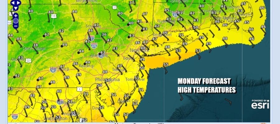
Winter Weather Advisories will be coming down this morning across Northwest New Jersey, northeast to the Hudson Valley and Connecticut. Overnight we saw some areas inland get a coating to an inch or even two in spots. Most areas have gradually switched over to rain or drizzle. Some cold spots in Connecticut are still hanging on to some snow. Otherwise today wlll be about a warm front going by and temperatures will rise as the day wears on. To the south we have warmer air in Southern New Jersey and Southern Pennsylvania. High temperatures which probably won’t be met until later this evening will be in the mid 40s to lower 50s.
SATELLITE WITH LIGHTNING STRIKES

WEATHER RADAR

A weather front will be approaching tonight and this could set off another round of showers overnight but thry should be long gone by morning. Temperatures overnight will hold mostly in the 40s. Tuesday with the front offshore we will break out into sunshine. It will be very warm and we might even see some record high temperatures being set. Most highs will be in the upper 50s and lower 60s.


We will see temperatures a bit cooler Wednesday with highs in the upper 40s to lower 50s. Look for arriving clouds and some showers developing late in the day as another cold front approaches. The cold front will have a wave on it. Most of the rain will be gone by daybreak Thursday morning but the front will likely stall out to the south and that will set up another storm system. This one will be diving southeast from the Great Lakes and then redeveloping offshore Friday night and early Saturday.

There is also cold air coming in behind this low so we will throw in the chance for a little rain or snow and mostly snow inland for Friday night into Saturday morning. It would seem that development of the low will be far enough offshore to prevent something more substantial. It will leave us in a very cold air mass for the weekend and the start of Christmas week.
BE SURE TO DOWNLOAD THE FREE METEOROLOGIST JOE CIOFFI WEATHER APP &
ANGRY BEN’S FREE WEATHER APP “THE ANGRY WEATHERMAN!
MANY THANKS TO TROPICAL TIDBITS FOR THE USE OF MAPS
Please note that with regards to any severe weather, tropical storms, or hurricanes, should a storm be threatening, please consult your local National Weather Service office or your local government officials about what action you should be taking to protect life and property.


