
Powerful Cold Front Heads East
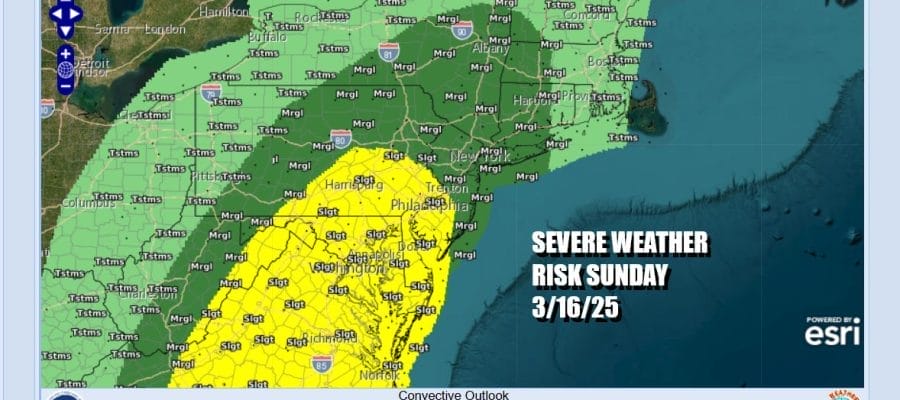
Severe Weather Risks Loom Late Sunday Into Sunday Night

We have arrived at the doorstep of the weekend and it is going to start out dry but end with showers, thunderstorms and the potential for severe weather. Before we get there however we still have an onshore flow today and this will keep temperatures in check once again. Overnight low clouds will burn off and we should see some breaks of sun especially inland. However that back door front will start to move northward in response to a developing major storm in the Plains. Highs today will be in the 50s with cooler 40s along the immediate coast.
SATELLITE WITH LIGHTNING STRIKES

WEATHER RADAR

Tonight we will see low clouds and some drizzle come in from the east as temperatures hold in the 40s to near 50. We have no serious weather issues for Saturday other than low clouds that will be a bit more stubborn to burn off. The old backdoor cold front will start moving northward as a warm front. Look for lots of clouds Saturday with minimal sun except perhaps for inland areas where the sun could break through at some point. Temperatures will be on the rise and reach the 60s inland and the 50s along the coast.

Sunday is going to be a busy day weather wise. A powerful cold front will move eastward from the Plains to day to the East Coast Sunday. This front will be producing widespread severe weather today across the Mississippi River Valley and from the Ohio Valley to the Deep South Saturday. Sunday it will be our turn.
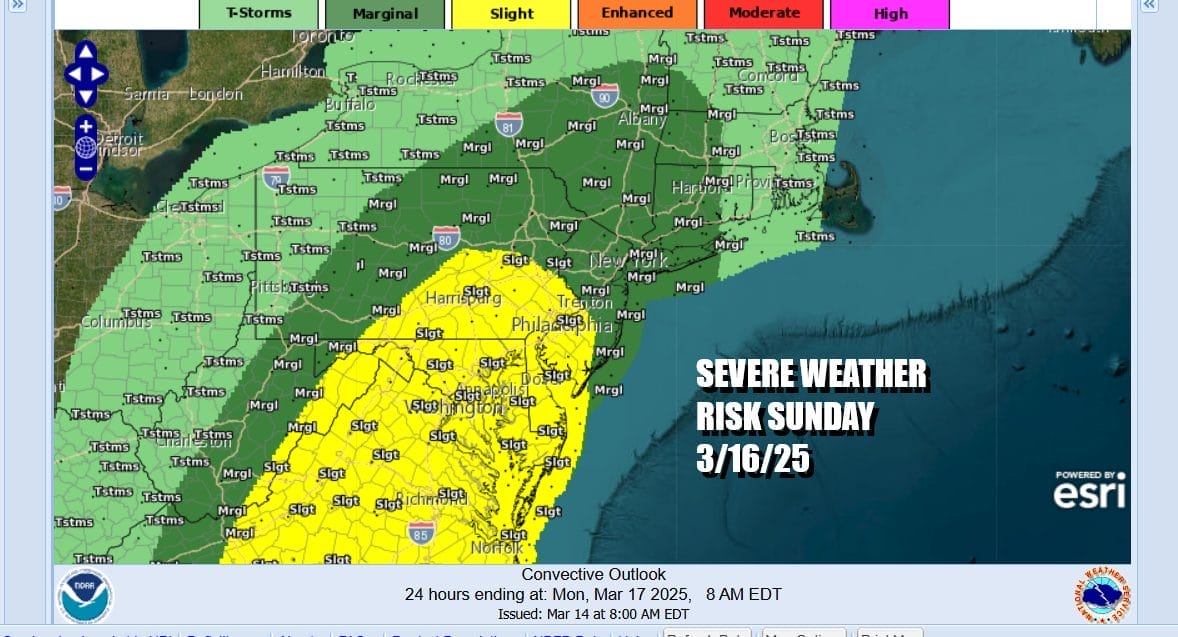
The Storm Prediction Center has a marginal risk for isolated severe thunderstorms late Sunday into Sunday night from Central New Jersey and Northeast Pennsylvania north and east. A slight risk for clusters of severe thunderstorms is indicating for the South Central and Southeastern Pennsylvania, Southern New Jersey and points southward.

The front Sunday will also produce some much needed rain on the order of 3/4 inch to 1.25 inches with some higher amounts possible in heavier thunderstorms. The European and other models are bullish on this idea. Hopefully severe thunderstorms will be kept at a minimum. Southerly winds will increase to 30 to 40 mph in gusts Sunday after noon and evening. Away from the ocean temperatures will be in the 60s. Much of Sunday dayside will be dry before storms move in late in the day. Temperatures will be in the 60s to near 70 inland and 50s to near 60 immediate coast.

The front should move through Sunday night and weather conditions will improve Monday and Tuesday. Temperatures will be on the mild side of average for the start of next week. It also looks to be dry through Wednesday before another cold front heads east with showers and thunderstorms next Thursday.
BE SURE TO DOWNLOAD THE FREE METEOROLOGIST JOE CIOFFI WEATHER APP &
ANGRY BEN’S FREE WEATHER APP “THE ANGRY WEATHERMAN!
MANY THANKS TO TROPICAL TIDBITS FOR THE USE OF MAPS
Please note that with regards to any severe weather, tropical storms, or hurricanes, should a storm be threatening, please consult your local National Weather Service office or your local government officials about what action you should be taking to protect life and property.


