
Onshore Flow Keeps It Cloudy & Cool Today Rain Thunderstorms Late Sunday

The weekend begins with the old back door cold front across Virginia and the onshore flow which is keeping things rather cloudy cool and raw. Unlike the last couple of days where the clouds did burn off for the most part today it will be more of a struggle. Satellite loops show clouds locked in well inland and it is unlikely that we will see these clouds burn off. This means temperatures today will likely stay in the 50s all day with readings closer to 50 near the coast. While the radars are not picking up much, there is spotty drizzle around and that will be the case for most of the day especially near the coast.
SATELLITE WITH LIGHTNING STRIKES

WEATHER RADAR

We will continue to see clouds and some patchy drizzle overnight as temperatures hold mostly in the upper 40s to lower 50s but winds will start to turn more to the south as the warm front nears. Sunday will be a cloudy day with an increasing south wind. You can expect those winds to pick up to 20 to 30 mph with some higher gusts later in the day and into Sunday night as the front closes in.

The warm front should make it through New Jersey and into the Hudson Valley and in these areas skies could brighten or perhaps eve the sun might break through. Temperatures inland will be in the 60s to near 70 degrees while areas on Long Island and Southern New England will be in the 50s to perhaps low 60s by days end. Then we get into the showers and thunderstorms as the front presses in later Sunday afternoon into Sunday night.

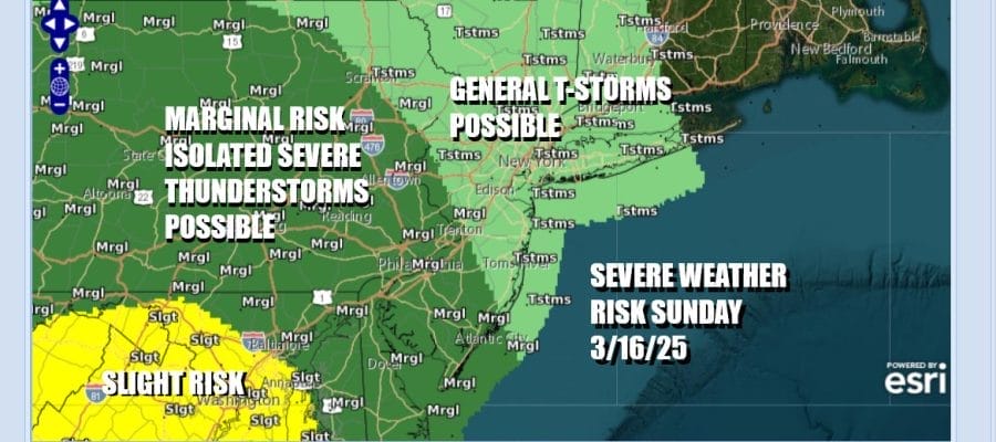
The Storm Prediction Center has pared back the severe weather risk for Sunday further south on the idea that the warm front will have a tougher time getting northward into Upstate NY and New England. Most of the area could see some general thunderstorms in the mix. Southern New Jersey and Pennsylvania southward will be in the marginal risk zone for isolated severe thunderstorms. Should the front show signs of pushing further north than risk areas may need to be adjusted further north.
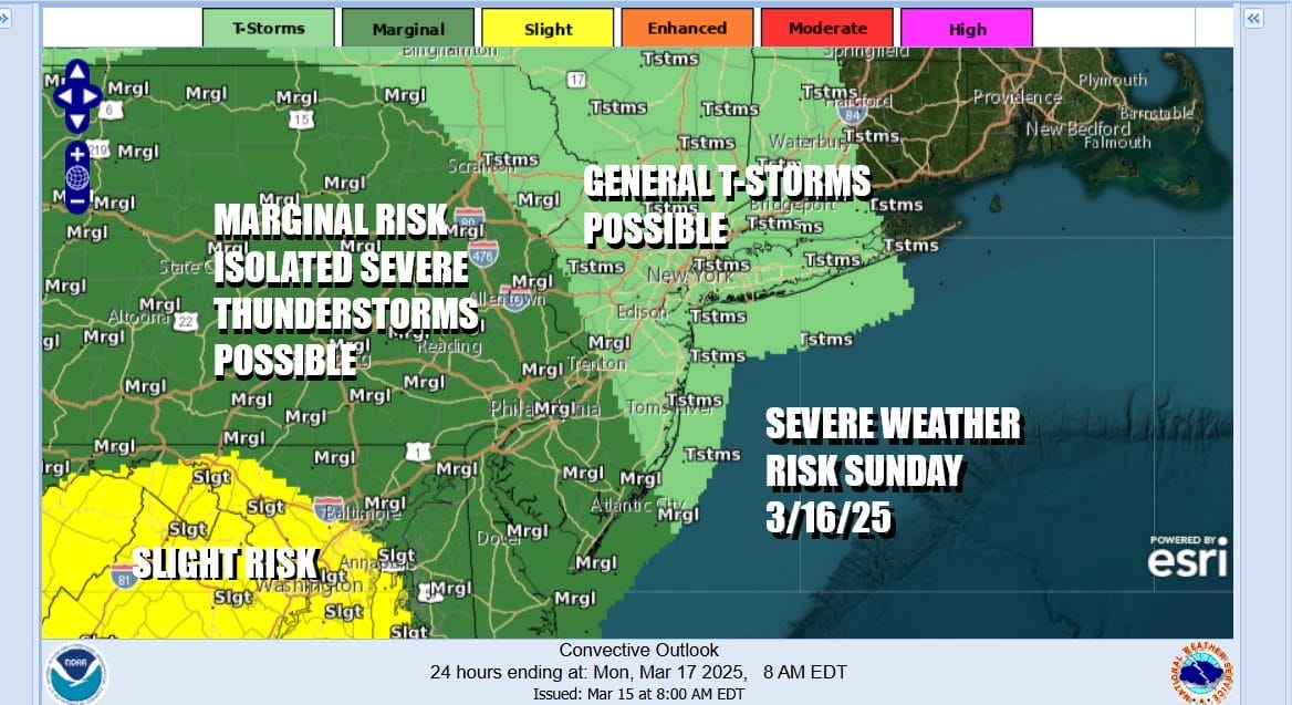
As far as rainfall is concerned, 3/4 of an inch to 1.25 inches seems reasonable with higher amounts in Southern, Southeastern New England and Long Island as the front will slow down as it moves offshore Sunday night. Along the coast rain will linger Monday morning until midday. Inland we will see slow improvement. Most of next week will be dry with warmer than average temperatures. The next cold front is not due to arrive until late Thursday.
BE SURE TO DOWNLOAD THE FREE METEOROLOGIST JOE CIOFFI WEATHER APP &
ANGRY BEN’S FREE WEATHER APP “THE ANGRY WEATHERMAN!
MANY THANKS TO TROPICAL TIDBITS FOR THE USE OF MAPS
Please note that with regards to any severe weather, tropical storms, or hurricanes, should a storm be threatening, please consult your local National Weather Service office or your local government officials about what action you should be taking to protect life and property.


