Plowing Snow In The Midwest Cities
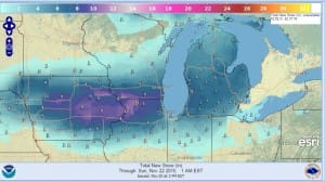
Plowing snow in Chicago, Milwaukee and a few other cities tonight and you can thank the first developing wave of low pressure heading out of Iowa and heading for Toronto! Winter Storm Warnings are posted for those and other cities across the midwest and a general 4 to 8 inch snow is possible except lower near lake shores thanks to the still warm water temperatures keeping things a little warmer there and in some urban areas near the lakefront. This weather system won’t be doing anything of consequence here as it tracks well north and west of us. It will bring a cold front through here Sunday morning and with that a shower at most is possible.
Before we get to Sunday however we do have tonight and Saturday. The satellite loop shows clear skies overhead however you see the clouds now racing across the midwest. Those clouds will arrive here during Saturday. Lows tonight should be in the 30s to near 40 in the warmest urban areas. Saturday’s highs will be in the upper 40s to lower 50s. Since there is no moisture feed from either the Atlantic or the Gulf of Mexico, the front comes through Sunday morning and then it turns colder for Sunday night and Monday with. Sunday’s highs will occur in the morning near or just over 50 and then drop into the 40s during the afternoon.


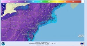
By Monday morning lows will be in the 20s to lower 30s. Monday’s highs will just be into the 40s.
Longer range look for the next high to build offshore east of New England much like this one did but there doesn’t appear to be any major threat for any rain here at least through Thanksgiving day and possibly the entire week.
JOESTRADAMUS ON WARM NOVEMBERS AND WHETHER THEY MEAN SNOWLESS WINTERS
JOESTDAMUS ON THE SPLIT FLOW AND SUBTROPICAL JET
JOESTRADAMUS LATEST ON THE LONG RANGE
JOESTRADAMUS ON TYPHOO IN-FA AND THE IMPACT ON THE LONG RANGE


