Weather Pattern Change Latest Outlook
Weather Pattern Change Latest Outlook
We have been talking about a gradual pattern change taking place beginning around the middle of the month of November. REMEMBER THAT PATTERN CHANGE IS A PROCESS AND NOT AN EVENT. Based on model runs over the last week or so I continue to believe that this is going to be the case. Also remember that THE PATTERN CHANGE YOU GET MAY NOT NECESSARILY BE THE PATTERN CHANGE you are looking for.
One of the things we are seeing is encouraging from the standpoint of the drought. It appears that we may be transitioning to a pattern that favors more frequent precipitation events in the coming weeks. The European model and the Canadian model want to start it next week with the first of 2 systems moving toward the east coast. We outlined the first potential event on a JOESTRADAMUS post earlier today as we examine the bullish European Model and the Canadian model and the not so bullish GFS model. The midcycle GFS remains weak with a lead system for next Tuesday Wednesday.
WEATHER PATTERN CHANGE MORE ACTIVE PACIFIC JET BRINGING MORE STORMS INLAND
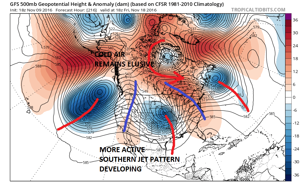
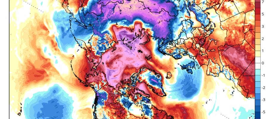
However longer term it appears that the Pacific Jet is going to be very active sending weather systems moving across the US beginning next week. This is about an active a jet stream pattern that we have seen in a long long time. Even going back to last winter we saw system after system in the west deflected well west of our area leaving us with very little in terms of rain events let alone snow events. The cold air part of the equation through next week however remains elusive as Canada remains warm and cold air remains locked up over Siberia and Europe at least for now.
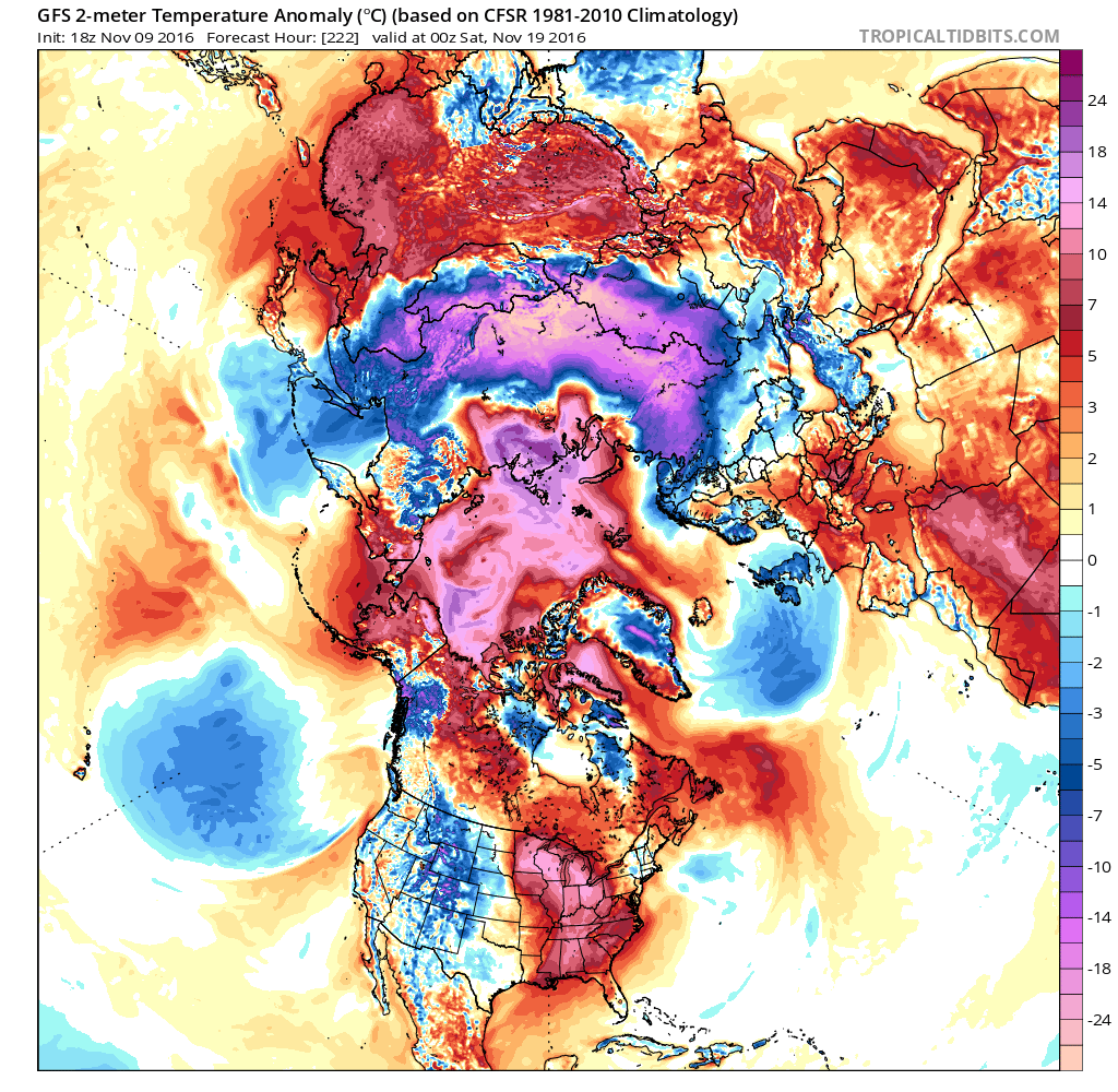
You can see on the hemispheric view where all the cold air is at the moment. Much of the polar region remains warm with just pockets of below normal temperatures in scattered areas of North Central Canada. The pattern still needs to correct quite a bit in order for that cold air in Siberia to crack the wall over the polar regions and spread into North America. This may take some time. Cold weather and winter weather lovers need to remember that this is still November so to have a warm looking pattern now need not necessarily mean this will be the case as we head toward the end of November and the beginning of December. Keys going forward will be how much if any blocking develops over the Atlantic. Signals here are mixed at the moment. The upper air structure across the Northern Pacific continues to be in transition to something less hostile to colder air coming into North America. Obviously the atmosphere has a lot of work to do. We are evolving into something different but right now it is very hard to figure out what exactly that is going to be.
MANY THANKS TO TROPICAL TIDBITS FOR THE WONDERFUL USE OF THE MAPS
SNOW REMOVAL COMPANIES FOR YOUR WINTER NEEDS
LONG ISLAND ROCKLAND COUNTY Connecticut

![]()


WINTER 2016-2017 PART 1 OCEAN WATER TEMPERATURES
WINTER 2016-2017 PART 2 ARCTIC SEA ICE AND SIBERIAN SNOW COVER
FiOS1 News Weather Forecast For Long Island
FiOS1 News Weather Forecast For New Jersey
FiOS1 News Weather Forecast For Hudson Valley
NATIONAL WEATHER SERVICE SNOW FORECASTS
LATEST JOESTRADAMUS ON THE LONG RANGE
Weather App

Don’t be without Meteorologist Joe Cioffi’s weather app. It is really a meteorologist app because you get my forecasts and my analysis and not some automated computer generated forecast based on the GFS model. This is why your app forecast changes every 6 hours. It is model driven with no human input at all. It gives you an icon, a temperature and no insight whatsoever.
It is a complete weather app to suit your forecast needs. All the weather information you need is right on your phone. Android or I-phone, use it to keep track of all the latest weather information and forecasts. This weather app is also free of advertising so you don’t have to worry about security issues with your device. An accurate forecast and no worries that your device is being compromised.
Use it in conjunction with my website and my facebook and twitter and you have complete weather coverage of all the latest weather and the long range outlook. The website has been redone and upgraded. Its easy to use and everything is archived so you can see how well Joe does or doesn’t do when it comes to forecasts and outlooks.
Just click on the google play button or the apple store button on the sidebar for my app which is on My Weather Concierge. Download the app for free. Subscribe to my forecasts on an ad free environment for just 99 cents a month.
Get my forecasts in the palm of your hand for less than the cost of a cup of Joe!
![]()
