OPHELIA AIMING TOWARD IRELAND LANDFALL MONDAY
BREAST CANCER AWARENESS MONTH
OPHELIA AIMING TOWARD IRELAND LANDFALL MONDAY
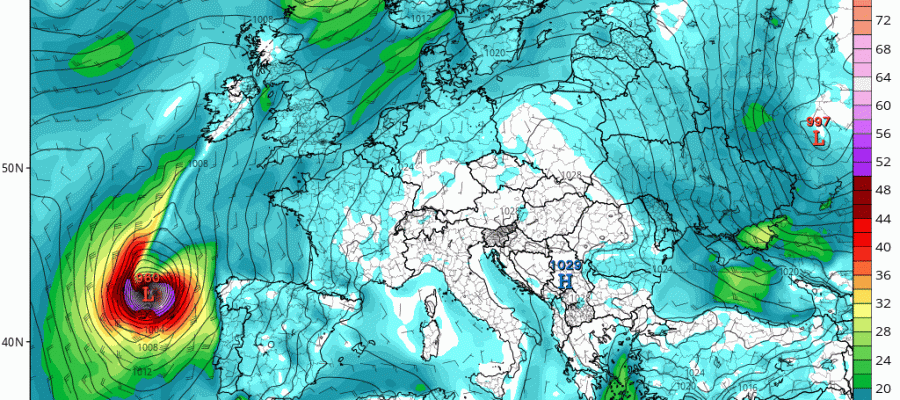
Hurricane Ophelia is racing northeastward now at 35 mph and it is going to begin transitioning into a powerful extra tropcial or post tropical cyclone. Landfall on the Southwest shores of Ireland will occur on Monday around mid to late morning. Weather models overnight were fairly consistent with this idea. Ophelia is beginning to become a bit distorted due to its fast forward motion and it is gaining latitude very quickly. The fast forward motion will likely create hurricane force gusts to the east of the circulation center which will impact much of Ireland with very strong winds on Monday.

…OPHELIA NOW TAKING AIM ON IRELAND…
…EXPECTED TO BECOME A POWERFUL POST-TROPICAL CYCLONE BY TONIGHT…
SUMMARY OF 500 AM AST…0900 UTC…INFORMATION
———————————————-
LOCATION…39.0N 18.3W
ABOUT 475 MI…765 KM E OF THE AZORES
ABOUT 965 MI…1550 KM SSW OF MIZEN HEAD IRELAND
MAXIMUM SUSTAINED WINDS…105 MPH…165 KM/H
PRESENT MOVEMENT…NE OR 45 DEGREES AT 35 MPH…56 KM/H
MINIMUM CENTRAL PRESSURE…964 MB…28.47 INCHES
WATCHES AND WARNINGS
——————–
There are no coastal tropical cyclone watches or warnings in effect.
Interests in Ireland should monitor products issued by Met Eireann,
and interests in the United Kingdom should monitor products issued
by the UK Met Office.
DISCUSSION AND 48-HOUR OUTLOOK
——————————
At 500 AM AST (0900 UTC), the center of Hurricane Ophelia was
located near latitude 39.0 North, longitude 18.3 West. Ophelia is
moving toward the northeast near 35 mph (56 km/h). A continued
northeastward motion with an increase in forward speed is expected
today, followed by a turn toward the north-northeast tonight. On the
forecast track, the center of Ophelia will approach Ireland on
Monday.
Maximum sustained winds have decreased to near 105 mph (165 km/h)
with higher gusts. Some additional weakening is expected today and
on Monday, but Ophelia is forecast to become a powerful
post-tropical cyclone with hurricane-force winds as it approaches
Ireland on Monday.
Hurricane-force winds extend outward up to 45 miles (75 km) from the
center and tropical-storm-force winds extend outward up to 150 miles
(240 km).
The estimated minimum central pressure is 964 mb (28.47 inches).
Ophelia’s eye recently passed near a drifting buoy that measured a
pressure of 970.9 mb (28.67 inches).
HAZARDS AFFECTING LAND
———————-
WIND: Gale-force winds are expected to begin across southern
Ireland by early Monday morning and gradually spread northward
across the country during the day. Hurricane-force winds are
expected to reach the southern portions of Ireland by Monday
afternoon and spread inland across the country into Monday night.
Preparations to protect lives and property should be rushed to
completion by this afternoon.
Wind speeds atop and on the windward sides of hills and mountains
are often up to 30 percent stronger than the near-surface winds
indicated in this advisory, and in some elevated locations could be
even greater.
RAINFALL: Ophelia is expected to produce rainfall amounts of 2 to
3 inches (50 mm to 75 mm) with isolated totals near 4 inches (100
mm) through Tuesday across western Ireland and Scotland. Across
eastern Ireland, rainfall amounts will average around 1 inch (25 mm)
or less.
STORM SURGE: A dangerous storm surge is expected to produce
significant coastal flooding near and to the east of where the
center makes landfall. Near the coast, the surge will be
accompanied by large and destructive waves.

Overnight weather models bring in strong winds to the south shores of Ireland overnight with the peak winds during Monday morning. Because of the extratropical nature of the storm at this point, there will not be that much rain east of the track of the surface low. The heaviest rain will fall along the west and north coast of Ireland and Northwestern Scotland. Over England it will be breezy to occasionally wind but there will be very little rain as the track of Ophelia is too far to the west.
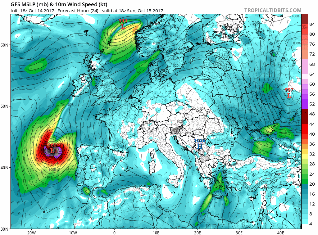
GFS WIND FORECAST OPHELIA SUNDAY INTO MONDAY CLICK TO ANIMATE
Look for additional updates today on my youtube channel as we livestream Hurricane Ophelia
MANY THANKS TO TROPICAL TIDBITS FOR THE WONDERFUL USE OF THE MAPS
 GET JOE A CIGAR IF YOU LIKE

SHOP THE JOESTRADAMUS STORE
Weather App

Don’t be without Meteorologist Joe Cioffi’s weather app. It is really a meteorologist app because you get my forecasts and my analysis and not some automated computer generated forecast based on the GFS model. This is why your app forecast changes every 6 hours. It is model driven with no human input at all. It gives you an icon, a temperature and no insight whatsoever.
It is a complete weather app to suit your forecast needs. All the weather information you need is right on your phone. Android or I-phone, use it to keep track of all the latest weather information and forecasts. This weather app is also free of advertising so you don’t have to worry about security issues with your device. An accurate forecast and no worries that your device is being compromised.
Use it in conjunction with my website and my facebook and twitter and you have complete weather coverage of all the latest weather and the long range outlook. The website has been redone and upgraded. Its easy to use and everything is archived so you can see how well Joe does or doesn’t do when it comes to forecasts and outlooks.
Just click on the google play button or the apple store button on the sidebar for my app which is on My Weather Concierge. Download the app for free. Subscribe to my forecasts on an ad free environment for just 99 cents a month.
Get my forecasts in the palm of your hand for less than the cost of a cup of Joe!