Onshore Flow Showery Rains Wednesday Especially Coast, Far Less Inland
Slow Improvement Late Week

Onshore Flow Showery Rains Wednesday Especially Coast, Far Less Inland
Slow Improvement Late Week
Weather conditions are changing today and actually the seeds have been planted a few days ago with an onshore flow (wind off the ocean). At first the air was too dry but now some moisture has started to come in and we have seen it in the form of overnight low clouds. To the south we have the remnant low from a potential tropical cyclone that never reached tropical storm status. Rain from this system extends from Northeast Georgia to Eastern North Carolina and Virginia. Clouds from this system will be pushing northward today so we will call it cloudy to partly sunny as far as our weather goes. Temperatures today will be mostly in the 70s.
SATELLITE WITH LIGHTNING STRIKES

WEATHER RADAR

Look for cloudy skies tonight with lows in the 60s, maybe a few upper 50s inland north and northwest of the coast. The moisture from the south will move northward Wednesday and it is likely that we will see some showery rains around. However the system is a weak one and the highest chances for rain will be along coastal areas especially Southeastern New England and Southern New Jersey southward.

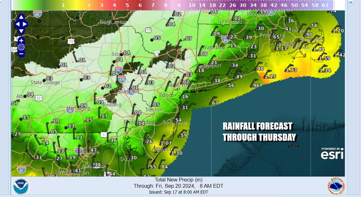
Rainfall amounts are going to vary from less than a quarter of an inch north and northwest of New York City and Philadelphia. South and east of that line rainfall amounts will range from about a quarter to a half inch and then amounts go up in Southern New Jersey and Southeastern New England where there is a fair chance of seeing an inch or so of rain.
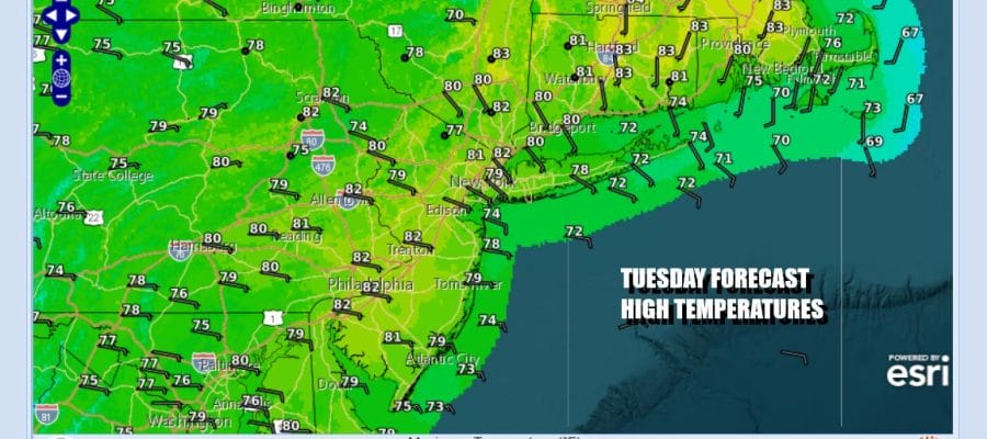
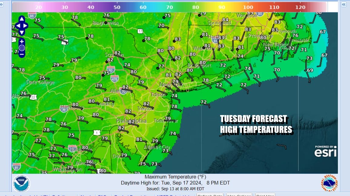
Between the clouds, the rain, and the onshore flow, temperatures Wednesday are not likely to go anywhere. Most highs will reach the low and middle 70s but while it is raining, temperatures will settle down to the lower end of that range. The onshore flow is also going to create coastal flooding issues at high tide beginning Wednesday and probably lasting right through the weekend.
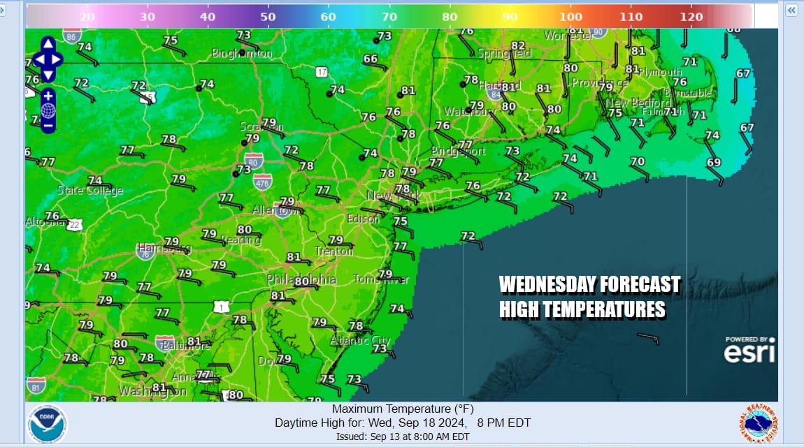
Once this system plays through Wednesday we will start to see some improvement but it will be rather slow to materialize. Another high is forecast to build southwestward from Eastern Canada but in the meantime we will have low pressure offshore and an onshore flow keeping much of the area in clouds Thursday with highs in the low to mid 70s. Gradually that high will build southward Friday and over the weekend and that should allow for some sunshine to develop Friday and right now the weekend is looking to be dry with no rain, some sunshine is forecast for both Saturday and Sunday and we will have a cool northeast to east wind. Highs will be in the lower 70s Friday and in the upper 60s to some lower 70s over the weekend.
BE SURE TO DOWNLOAD THE FREE METEOROLOGIST JOE CIOFFI WEATHER APP &
ANGRY BEN’S FREE WEATHER APP “THE ANGRY WEATHERMAN!
MANY THANKS TO TROPICAL TIDBITS FOR THE USE OF MAPS
Please note that with regards to any severe weather, tropical storms, or hurricanes, should a storm be threatening, please consult your local National Weather Service office or your local government officials about what action you should be taking to protect life and property.
(Amazon is an affilate of Meteorologist Joe Cioffi & earns commissions on sales.)


