Offshore Storm Throws Back Some Moisture Westward But Not A Big Deal
Very Warm Humid Week Ahead

Offshore Storm Throws Back Some Moisture Westward But Not A Big Deal
Very Warm Humid Week Ahead

The day starts out nice and sunny and if you are inland and west of the coast you are going to have a nice day from start to finish. Sunshine will take temperatures to the mid and upper 80s. Humidity levels are going up somewhat but not to oppressive levels. If you are along the coast you will notice on satellite and radar loops that there is a developing small storm system offshore that is throwing clouds back westward to the coast.
SATELLITE WITH LIGHTNING STRIKES

WEATHER RADAR

The low is totally non tropical in nature however it will start throwing clouds back westward from Southeastern New England to Long Island and Coastal New Jersey. Any rain from this system likely holds off until after sunset. The low will rotate its way north northwestward and we will start to see bands of rain spread westward tonight into the first part of Monday as most short term models indicate.

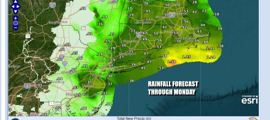
There really isn’t much time for this system to become tropical in nature and it is also associated with a cold upper air low aloft so it will not be able to completely shed its cold core characteristics. It will be about clouds and bands of rain working their way back westward overnight into the first part of Monday. The heaviest rain will likely be along the coast of Southeastern New England where an inch or 2 could fall.

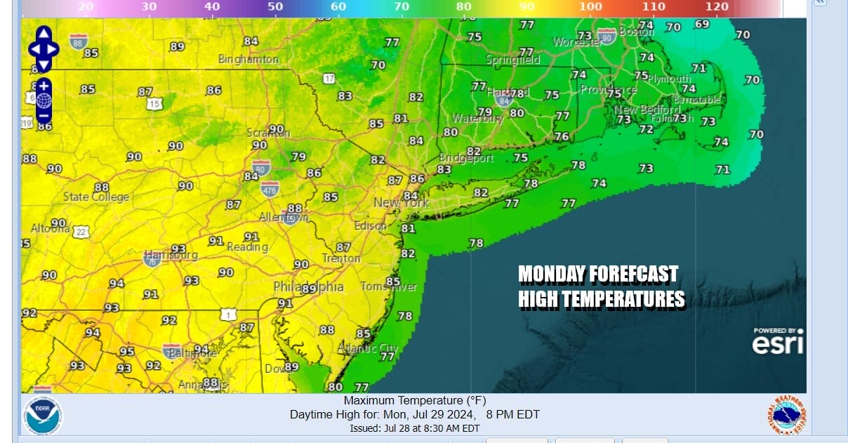
Most areas could see a quarter to a half inch or rain but the amounts do drop off as you head west into Western New Jersey and the Hudson Valley. Monday will be a day of clouds with more sun to the west and far less to the east as the low pressure area lingers. That means there will be a 10 degree spread in high temperatures. Along the coast east to Southeastern New England highs will be in the upper 70s to lower 80s at best. Western areas will see more sun so if you are west of NYC and the coast, highs will reach the middle 80 and even some upper 80s.
Tuesday and Wednesday will be very warm and humid days. The coastal storm system will be long gone and we are going to be sitting in a summer no man’s land of some sunshine, increasing humidity, and the risk for scattered afternoon and evening thunderstorms. The extra moisture around probably keeps temperatures down a bit but daytime highs Tuesday and Wednesday will be in the mid to upper 80s with cooler readings at the shore. Temperatures likely start to head higher into the 90s Thursday and Friday with the next important weather front not expected to arrive until some time after next weekend.
BE SURE TO DOWNLOAD THE FREE METEOROLOGIST JOE CIOFFI WEATHER APP &
ANGRY BEN’S FREE WEATHER APP “THE ANGRY WEATHERMAN!
MANY THANKS TO TROPICAL TIDBITS FOR THE USE OF MAPS
Please note that with regards to any severe weather, tropical storms, or hurricanes, should a storm be threatening, please consult your local National Weather Service office or your local government officials about what action you should be taking to protect life and property.
(Amazon is an affilate of Meteorologist Joe Cioffi & earns commissions on sales.)


