
Nice Weekend Overall Low Pressure Offshore
Could Bring Some Downpours Sunday Night

Nice Weekend Overall Low Pressure Offshore
Could Bring Some Downpours Sunday Night

The weekend begins with the Northeast and Northern Mid Atlantic states in the middle of a dry air mass. This weekend is also the climatological peak of the summer with the average temperatures reaching the peaks before beginning a slow decline in August, The weekend is also complicated by a wave of low pressure developing off the North Carolina coast .

This low heads out to the east today and offshore so there are no issues in Eastern Pennsylvania to Southern New England. We will have lots of sunshine today (Saturday). Dew points remain on the low side in the 50s to around 60 making for reasonable humidity conditions. Most highs today will reach the middle 80s. It will be a little cooler along the shore where local sea breezes develop. Radars today
SATELLITE WITH LIGHTNING STRIKES

WEATHER RADAR

This coastal low takes a track to the east initially however thanks to the Bermuda high offshore flexing a bit of its muscle, the low turns northward about 300 miles offshore and then turns northwestward during the day Sunday. This time of year, systems like this could turn into tropical depressions or even tropical storms. While the low does organize somewhat, it seems that it doesn’t have enough time to develop into anything overly problematic.

This leaves us with mainly clear skies tonight and Sunday morning lows in the mid 60s to lower 70s. Sunday we will see dew points edging a little higher into the lower 60s which is not terrible though technically it is a little more humid than today. We will see sunshine to start. Coastal areas from New Jersey, Long Island and points east will see clouds arriving from the east and southeast as low pressure starts to move north and northwestward but remaining offshore.

Sunday highs will be in the mid to upper 80s inland where there will be more sunshine and fewer clouds. Coastal highs will reach into the 80s before clouds and an ocean wind take temperatures down a bit in the afternoon. Sunday night into Monday morning this offshore low could bring some rain back to coastal areas and perhaps some light rain showers inland.
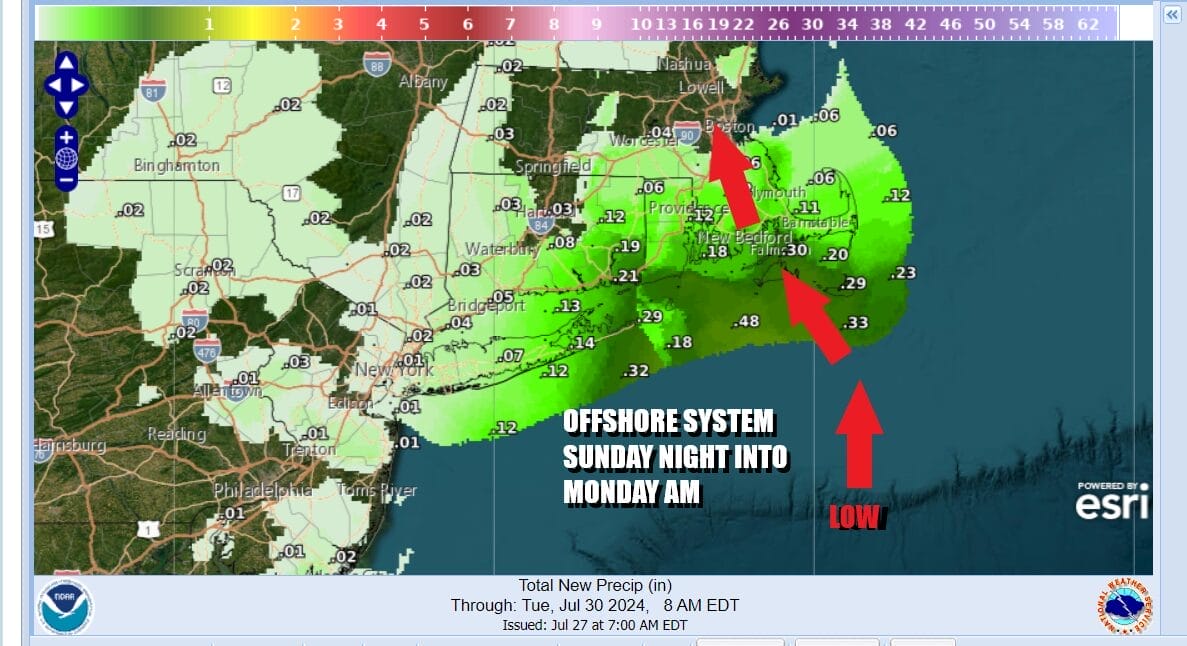
Rainfall amounts won’t be much. Generally we are talking about a few hundreths scattered around inland. There could be a steadier rain Sunday night over Eastern Long Island to Southeastern New England where up to a quarter inch or so is possible. The low should be weakening and moving northward into Coastal New England. Even the rain shield will weaken as it moves northward.
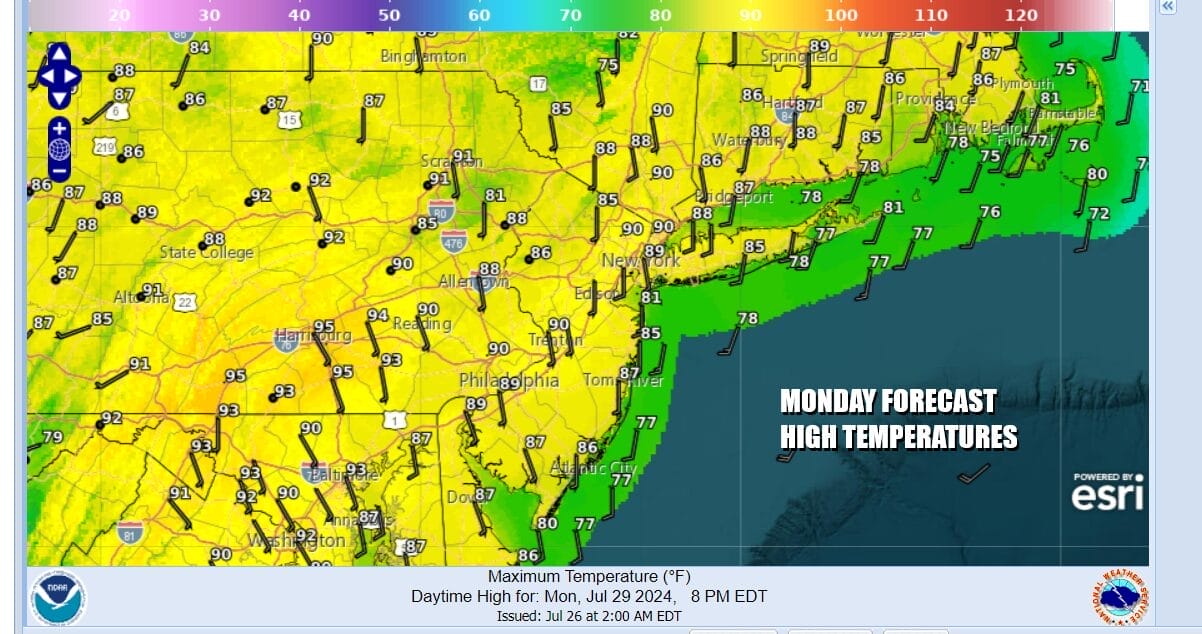
This leaves us very warm to hot and more humid for Monday to the point of discomfort. Dew poitns will reach into the upper 60s to near 70. We will see some sunshine Monday especially inland. There might be a few leftover clouds along the coast. Highs Monday will be in the upper 80s to around 90 or so inland with slightly lower temperatures near the coast.
BE SURE TO DOWNLOAD THE FREE METEOROLOGIST JOE CIOFFI WEATHER APP &
ANGRY BEN’S FREE WEATHER APP “THE ANGRY WEATHERMAN!
MANY THANKS TO TROPICAL TIDBITS FOR THE USE OF MAPS
Please note that with regards to any severe weather, tropical storms, or hurricanes, should a storm be threatening, please consult your local National Weather Service office or your local government officials about what action you should be taking to protect life and property.
(Amazon is an affilate of Meteorologist Joe Cioffi & earns commissions on sales.)


