DOWNLOAD MY NEW FREE JOESTRADAMUS WEATHER APP FOR ANDROID

WINTER STORM WARNING CONTINUES TONIGHT FOR NORTHERN NEW JERSEY HUDSON VALLEY & CONNECTICUT UP TO 8 INCHES OF ACCUMULATIONS
FOR NYC & LONG ISLAND WINTER WEATHER ADVISORY UP TO 4 INCHES OR SO
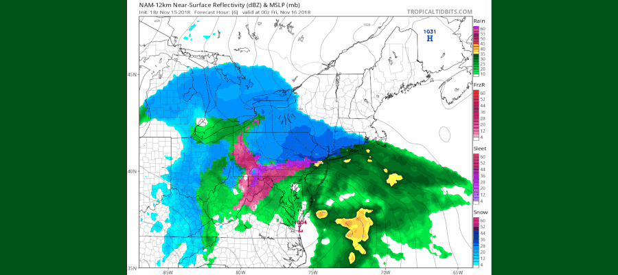
We continue to wait for that warmer air that is sitting just offshore and having a very tough time moving its way inland. Temperatures at 5pm have dropped into the 20s just inland of the coast while sitting in the low 30s along the coast. The NAM model has the best handle on all this and it matches up to the current radars and observations of rain verses snow very well. The time sequence here is from 7pm to 1am Friday.

Once the change over takes place the question of the 32 degree line becomes huge as we could see a period of sleet and freezing rain just inland of the coast. Areas in the Hudson Valley north of route 84 and in Northern New Jersey along and west of 287 and north of 78 may not get above freezing.
EASTERN SATELLITE

REGIONAL RADAR

LOCAL RADAR NEW YORK CITY

LOCAL RADAR PHILADELPHIA


The intensity of the precipitation will lessen overnight. Along the coast winds will pick up to 40 to 50 mph along the New Jersey shore and the south shore of Long Island. Total liquid precipitation of 1 to 2 inches is likely and there cold be some localized flooding. At least weather conditions should start to improve on Friday and the weekend looks good with some sunshine and highs in the 40s.
SUBSCRIBE TO PATREON FOR A WEATHER EXPERIENCE FREE OF ADS, EXCLUSIVE VIDEOS FOR MEMBERS ONLY AND MUCH MORE…STARTS AT $2 A MONTH..MESSAGE ME AT ANY TIME

MANY THANKS TO TROPICAL TIDBITS FOR THE USE OF MAPS
Please note that with regards to any tropical storms or hurricanes, should a storm be threatening, please consult your local National Weather Service office or your local government officials about what action you should be taking to protect life and property.
LATEST JOESTRADAMUS ON THE LONG RANGE

