
Not Exactly A Picture Perfect Weekend Warmer Monday Tuesday

Weather in 5/Joe & Joe Weather Show Latest Podcast
Not Exactly A Picture Perfect Weekend Warmer Monday Tuesday
The proximity of the storm to the east was certainly not a plus today. Nor is the very cold nature of the upper atmosphere thanks to an active northern jet stream. Most temperatures this afternoon topped out in the 50s. The satellite still shows a lot of cloud cover around though the sun does manage to cut through a few slivers from time to time. At least the radars are quiet and we should be dry tonight. Skies may try to partially clear with lows in the upper 30s to middle 40s.
SATELLITE

I didn’t see anything to change my mind regarding Sunday and the week ahead. We should see more sun but there will still be some clouds around Sunday as a weak upper trough hangs around. I had the mention for an isolated inland shower chance in the afternoon or evening. I will leave it in there though it is quite possible that they don’t form at all. Highs should be able to get back into the low and mid 60s.

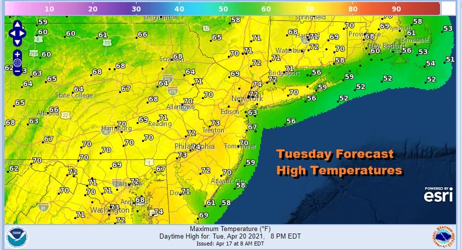
Monday and Tuesday look good overall with sunshine and some passing clouds. Depending on how much sun we could see some upside in the temperatures on both days and finish higher than advertised above. The next cold front is due Wednesday.

No changes here for midweek with clouds and showers for Wednesday. I will even throw in the chance for a thunderstorm as the front goes by. Highs will be in the 60s. Then another shot of cold air comes in for Thursday and Friday. The blocky pattern in the North Atlantic continues along with a northern jet stream that is delivering chilly air every couple of days. Remember we are talking relative to the time of year where highs are normally in the 60s. So when it is below average we are talking 50s for highs. When the cold air pulls out temperatures reflexively want to climb toward or even over 70 depending on how much sun. Next weekend could be setting up for some raw wet weather and we will be focusing on that in our long range outlooks.
BE SURE TO DOWNLOAD THE FREE METEOROLOGIST JOE CIOFFI WEATHER APP &
ANGRY BEN’S FREE WEATHER APP “THE ANGRY WEATHERMAN!
MANY THANKS TO TROPICAL TIDBITS FOR THE USE OF MAPS
Please note that with regards to any severe weather, tropical storms, or hurricanes, should a storm be threatening, please consult your local National Weather Service office or your local government officials about what action you should be taking to protect life and property.


