In And Out Sun Today And Sunday Warmer Monday Tuesday Showers Wednesday

Weather in 5/Joe & Joe Weather Show Latest Podcast
In And Out Sun Today And Sunday Warmer Monday Tuesday Showers Wednesday
Take a close look at the satellite picture and you can still see the very healthy signature of the storm of the last 2 days. It has finally moved off the New England coast but it is still not far enough out to sea yet. As a result we are still getting arms of cloud cover coming in from the northeast. There are large areas in between with sunshine so we will call it in and out sun for today. Temperatures are going to struggle but we should see highs in the 50s. We are still seeing some rain showers in coastal New England but those will dry up as they head west and south and overall the storm should pull most of those showers out to the east as the day wears on.
SATELLITE

We should at least be partially clear tonight but there is no big high behind this storm so it will be a bit of a struggle to get rid of all of the clouds. Morning lows Sunday will be in the mid 30s to lower 40s. One good thing about this time of year is that if you get any sun at all temperatures are going to want to climb into the 60s. While we still have remnants of this chilly air mass, and the prospect for some clouds, I think we will see enough sun in the mix to take temperatures into the low and middle 60s Sunday afternoon. I have been mentioning the chance for an isolated shower well inland and will leave that chance in there for Sunday evening though the chance is low.
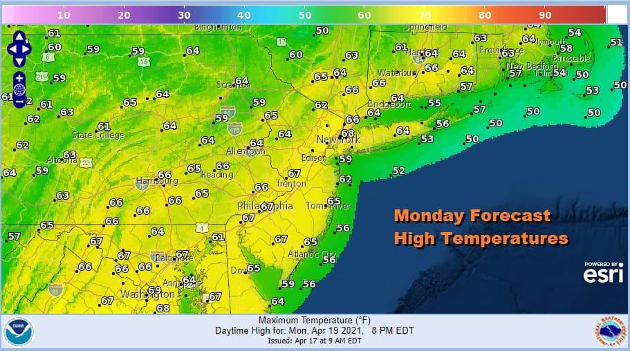
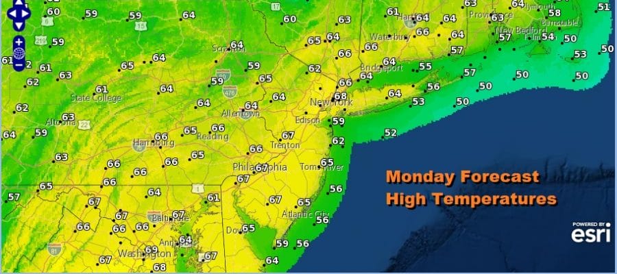
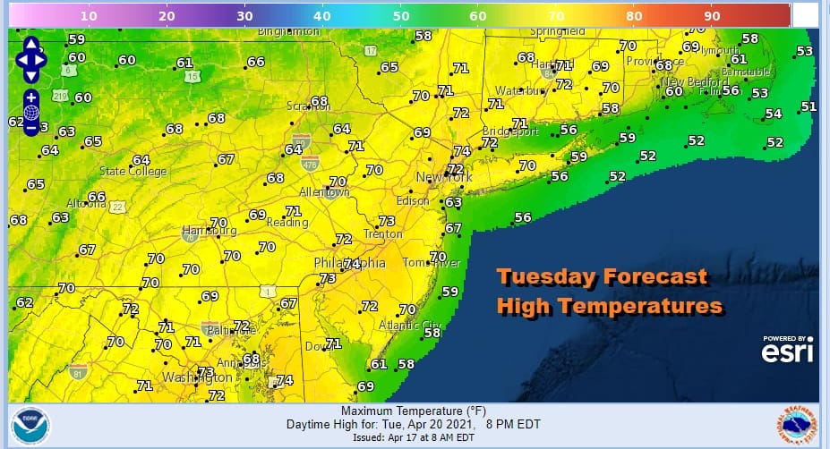
Monday begins a bit of a warm up. The winds will go west or west southwest. The chilly air of today will be long gone. The next cold front is not due until Wednesday. It will be about how much sun we get. If we get enough sun these temperatures on the forecast high temperature map could see a few degrees of upside with highs in the mid 60s to near 70 or so. Tuesday there could also be some upside with highs reaching low and even a few middle 70s which is higher than modeled.
Let’s move on to Wednesday which is when we see the next round of changes. Low pressure develops in the Ohio Valley and heads to New England with a trailing cold front. That brings clouds and the likelihood for showers with highs in the 60s.

That low is going to strengthen when it gets into Northern New England and that not only means that we finish next week with chilly temperatures about 10 degrees or so below average (highs will be in the 50s Thursday and Friday), it will also come with a tightening pressure gradient and windy conditions for both days. We should at least see some sun though to take the sting out of the air.
BE SURE TO DOWNLOAD THE FREE METEOROLOGIST JOE CIOFFI WEATHER APP &
ANGRY BEN’S FREE WEATHER APP “THE ANGRY WEATHERMAN!
MANY THANKS TO TROPICAL TIDBITS FOR THE USE OF MAPS
Please note that with regards to any severe weather, tropical storms, or hurricanes, should a storm be threatening, please consult your local National Weather Service office or your local government officials about what action you should be taking to protect life and property.


