Nor’easter Underway Heavy Rains Flash Flooding
Strong Winds To The East And Offshore
Weather in 5/Joe & Joe Weather Show Latest Podcast
Nor’easter Underway Heavy Rains Flash Flooding
Strong Winds To The East And Offshore
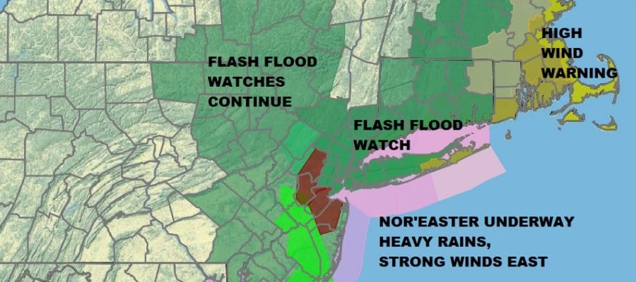
Our nor’easter is underway and we have already seen up to several inches of rain overnight into this morning and there is more rain to go. Flash Flood Watches continue area wide with many areas under various flash flood warnings. Winds have not been an issue yet and for the most part wind will not be a big deal for areas from NYC southward. Except along the immediate coast where winds will gust to gale force later today into tonight, winds should be manageable elsewhere.
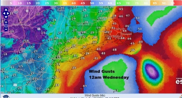
East of NYC winds will be picking up and we expect areas from Eastern Connecticut and Eastern Long Island eastward to see winds that could gust past 50 mph. Various high wind warnings are up as the map indicates. Southeastern New England will see the strongest winds tonight as the storm begins a counterclockwise loop back westward.
SATELLITE
WEATHER RADAR
Radars are loaded but notice the back edge is now in Southern New Jersey and Eastern Pennsylvania. What is happening is that the precipitation shield will begin to pivot north and northwest. This will bring the back edge of the rain to about NYC and Long Island around midday. It will stop moving northward and then begin to move back southwestward. The coastal storm will begin a counterclockwise loop and that prolongs the rain for many areas at least through the first half of tonight.
As far as rainfall is concerned many areas have seen 2 to 3 inches of rain overnight and this morning. Some areas will finish up in a range of 4 to 6 inches before it is all said and done. Obviously there has been and will continue to be flash flooding. Unlike what happened with Ida, the rains here are spread out over a longer period of time and that lessens the impact somewhat. Temperatures through all of this will be mostly in the mid 50s to around 60 or so. Weather conditions will improve somewhat on Wednesday though clouds will remain an issue along with the onshore flow. Thursday will be dry but cloudy as the next system approaches for Friday.
BE SURE TO DOWNLOAD THE FREE METEOROLOGIST JOE CIOFFI WEATHER APP &
ANGRY BEN’S FREE WEATHER APP “THE ANGRY WEATHERMAN!
MANY THANKS TO TROPICAL TIDBITS & F5 WEATHER FOR THE USE OF MAPS
Please note that with regards to any severe weather, tropical storms, or hurricanes, should a storm be threatening, please consult your local National Weather Service office or your local government officials about what action you should be taking to protect life and property.


