Noreaster Rain Snow Strong Winds Coastal Flooding
Noreaster Rain Snow Strong Winds Coastal Flooding
Hurricane Force Wind Warning Long Island & NYC Coastal Waters
High Wind Warning Coastal NJ, NYC Coastal CT & Long Island
Winter Storm Watch Sussex County NJ
Winter Weather Advisory Passiac County NJ, Orange Putnam & Dutchess Counties NY, NW Connecticut North of Rt 84
The noreaster that is headed our way is very impressive on the satellite loop this evening as it continues its march across the Gulf States, It has that signature comma shape on the satellite loop and severe weather continues across the Southeast and Florida. Meanwhile rain is beginning to gather steam and it will be moving northward along the coast overnight. Winds have already started to increase along coastal locations and it will reach Gale Force Monday morning across the entire forecast area.
SATELLITE LOOP

REGIONAL RADAR

LOCAL RADAR NEW YORK CITY

LOCAL RADAR PHILADELPHIA


Weather conditions will continue to deteriorate on Monday with heavy rains moving northward. Winds will increase to 30 to 40 mph with gusts over 60 mph common place from the New Jersey shore to Long Island. Tides will be 2 to 4 feet above normal at the high tide on Monday and moderate coastal flooding is expected since we are in between the full moon and the new moon.
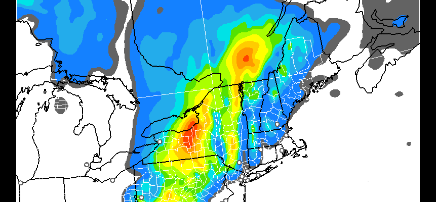
NOREASTER RAP MODEL SNOW FORECAST

NOREASTER NAM MODEL SNOW FORECAST
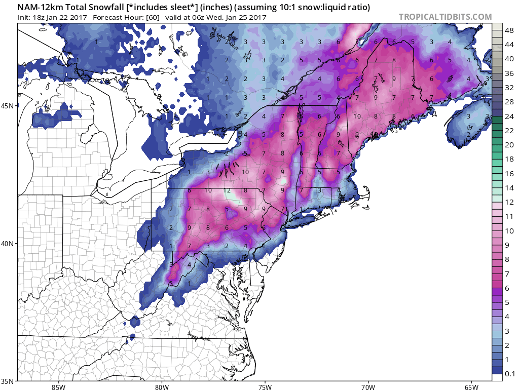
The two models above, the NAM model and the RAP model show two ideas among many. The NAM model remains aggressive and variations of the NAM model are even more aggressive in their snow outputs while the GFS and European are more like the RAP model in their view. The question is snow and sleet. Weather models continue to become progressively colder as we near the event. We expect rain to change over the sleet and snow in the areas currently under Winter Weather Advisories and Winter Storm Watches. This is a very tough call with regard to snow amounts given the limited amount of cold air. This could be offset by the energy of the system itself which is quite dynamic Be advised that the situation is very fluid and amounts forecast could go up or down radically as we draw closer and during the event itself.
SNOW REMOVAL COMPANIES FOR YOUR WINTER NEEDS
LONG ISLAND ROCKLAND COUNTY Connecticut

![]()

ROCKLAND COUNTY TRI STATE SNOW REMOVAL JOHNSTOWN PA


FiOS1 News Weather Forecast For Long Island
FiOS1 News Weather Forecast For New Jersey
FiOS1 News Weather Forecast For Hudson Valley
NATIONAL WEATHER SERVICE SNOW FORECASTS
LATEST JOESTRADAMUS ON THE LONG RANGE
Weather App

Don’t be without Meteorologist Joe Cioffi’s weather app. It is really a meteorologist app because you get my forecasts and my analysis and not some automated computer generated forecast based on the GFS model. This is why your app forecast changes every 6 hours. It is model driven with no human input at all. It gives you an icon, a temperature and no insight whatsoever.
It is a complete weather app to suit your forecast needs. All the weather information you need is right on your phone. Android or I-phone, use it to keep track of all the latest weather information and forecasts. This weather app is also free of advertising so you don’t have to worry about security issues with your device. An accurate forecast and no worries that your device is being compromised.
Use it in conjunction with my website and my facebook and twitter and you have complete weather coverage of all the latest weather and the long range outlook. The website has been redone and upgraded. Its easy to use and everything is archived so you can see how well Joe does or doesn’t do when it comes to forecasts and outlooks.
Just click on the google play button or the apple store button on the sidebar for my app which is on My Weather Concierge. Download the app for free. Subscribe to my forecasts on an ad free environment for just 99 cents a month.
Get my forecasts in the palm of your hand for less than the cost of a cup of Joe!


