NOREASTER HEADING UP THE COAST WEATHER ALERTS
COASTAL FLOOD WARNING FOR LONG ISLAND SOUTH & NORTH SHORE
FLASH FLOOD WATCH NYC LONG ISLAND LOWER HUDSON VALLEY CONNECTICUT
HIGH WIND WARNING FOR SUFFOLK COUNTY LONG ISLAND
WIND ADVISORIES NYC WESTERN LONG ISLAND SOUTHERN NEW ENGLAND
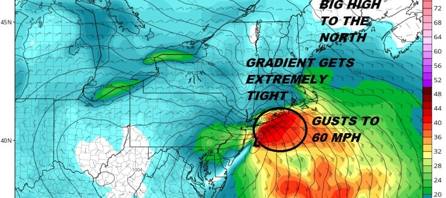
We are about to have a rocky late Friday night Saturday morning as low pressure pushes up the coast into a big high sitting just to the east of Nova Scotia. The tight pressure gradient could get even tighter Saturday morning as low pressure forms to the northeast of the main low and literally pinches the pressure gradient over Long Island and especially Eastern Long Island. Winds will howl from 4am to 9am with gusts to 50-60 mph likely.

Clouds are increasing and thickening up this evening with rains beginning in the Hudson Valley Southern New England and Long Island between 9pm and midnight. During tomorrow morning, the strongest winds, heavy rains and the high tides will all coincide which means it gets rough between 5am and 10am with peak winds probably between 7am and 9am. For Central and Eastern Long Island gusts to 60 mph or higher are not out of the question. Winds will be a less of an issue the further north and west of the coast you go. While it may be gusty in the 30 mph plus range for example in the Hudson Valley and Interior Connecticut it should be managable. However winds will be stronger in Southern Westchester and Coastal Connecticut with the strongest right on the coast.
EASTERN SATELLITE

REGIONAL RADAR

The heaviest rains will be during the morning hours and watch for some possible thunderstorms that could develop during the height of the storm. This could mean that rainfall amounts could exceed 2 inches in some areas though the general rain forecast is for 1 to 2 inches of rainfall.
LOCAL RADAR NEW YORK CITY

LOCAL RADAR PHILADELPHIA


In this area the rain could last into the afternoon Saturday but should start to shift northward. The low will move north of us Saturday night and weather conditions will improve so that Sunday at least will be rain free though there will be clouds around. There also should be some brightening of skies and perhaps a few breaks of sun. Another weaker system arrives with some showers late Sunday night into Monday morning and then we should dry out during the afternoon Monday.
There will be additional coverage on the Noreaster tonight and Saturday on the Patreon Platform
SUBSCRIBE TO PATREON FOR A WEATHER EXPERIENCE FREE OF ADS, EXCLUSIVE VIDEOS FOR MEMBERS ONLY AND MUCH MORE…STARTS AT $2 A MONTH..MESSAGE ME AT ANY TIME

MANY THANKS TO TROPICAL TIDBITS FOR THE USE OF MAPS
Please note that with regards to any tropical storms or hurricanes, should a storm be threatening, please consult your local National Weather Service office or your local government officials about what action you should be taking to protect life and property.
LATEST JOESTRADAMUS ON THE LONG RANGE

