No Weather Issues Through Christmas Day Next Storm System Arrives Tuesday

No Weather Issues Through Christmas Day Next Storm System Arrives Tuesday
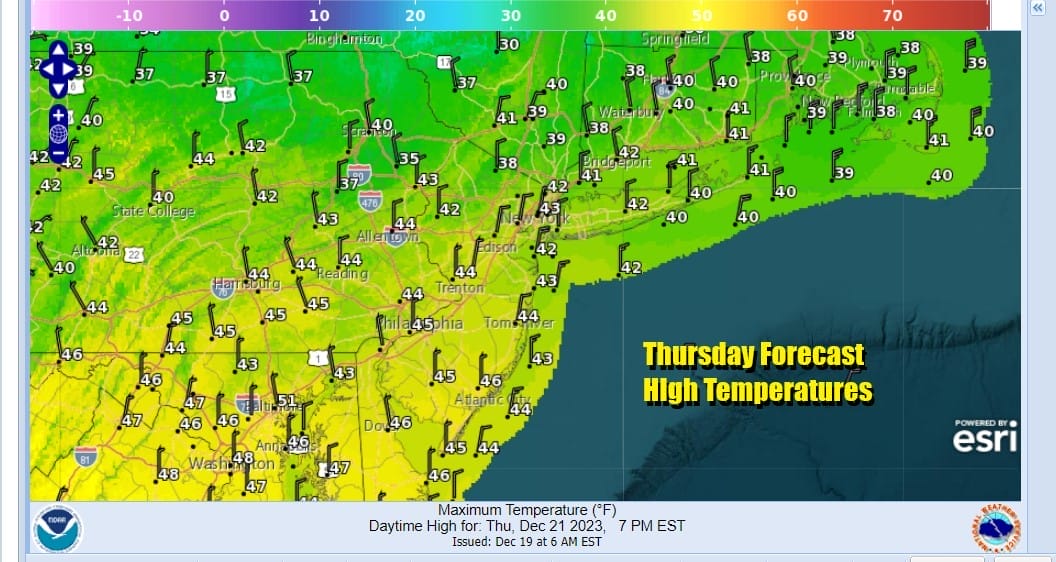
We are in a state of relative calm across much of the Eastern US and this is just in time for Christmas Eve and Christmas Day. There will be no weather related travel issues through Christmas which is a plus for those of you travelling to and from destinations in the Northeast and Mid Atlantic. In the meantime we have a very weak cold front overhead today as another high builds into Southeastern Canada and New England. This will keep things on the chilly side today and Friday. We have no issues today other than clouds as the radars are quiet. Skies should be no worse than partly sunny and highs will be in the low to mid 40s this afternoon.
SATELLITE WITH LIGHTNING STRIKES

WEATHER RADAR

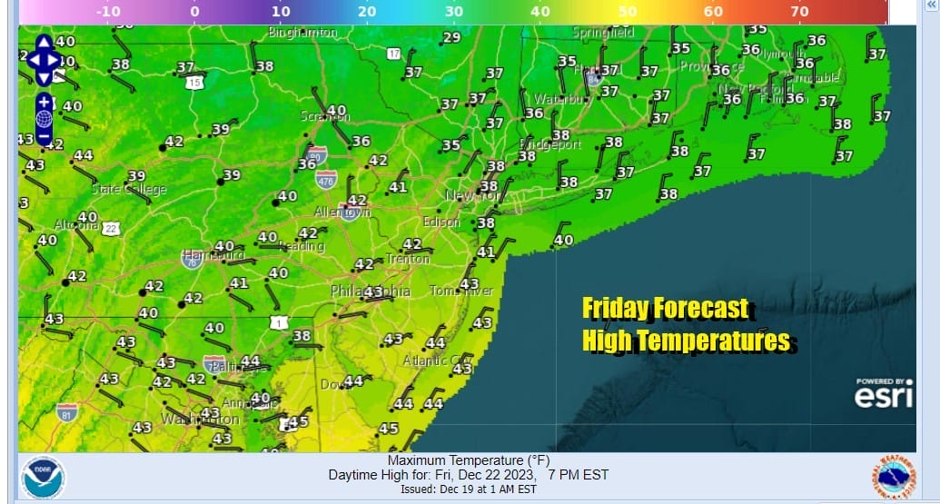
A northerly flow of colder air tonight at low levels will take temperatures down tonight to the 20s in most places and even a few upper teens in colder spots inland under mainly clear skies. Friday should be a decent day with no worse than partly sunny skies. Highs will be in the upper 30s to lower 40s which is about where we should be for this time of year.
Heading into the weekend we only have some minor issues Saturday night as a warm front approaches and moves through. Ahead of this Saturday we will see an increase in high clouds though there should still be a fair amount of sunshine. Saturday highs will reach the low and middle 40s.

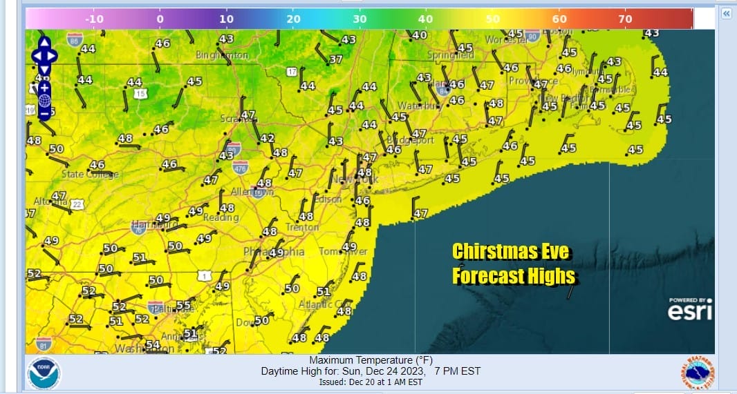
Sarturday night into Sunday morning the warm front will pass and most of the limited shower activity with this will pass to our north. However we will throw in the chance for a passing light shower or sprinkle Saturday night into Sunday morning. Then as the day wears on Sunday, Christmas Eve, we see clouds giving way to some sunshine. Highs will be in the mid to upper 40s.
Sunday night will be dry and nice with reasonable temperatures in the 30s to near 40. Christmas Day will be a partly sunny day. Some high clouds might come in later in the day but no rain or snow is forecast. Monday highs will be in the relatively mild 40s to around 50 degrees.

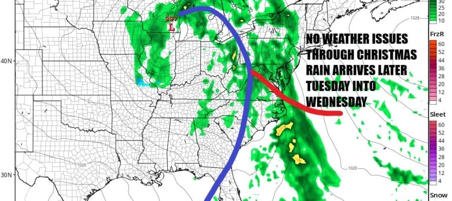
While our weather through Christmas Day is quiet low pressure from the Central Plains with a trailing cold front will move through the Mississippi Valley to the Great Lakes Sunday with rain for those regions all the way north to the Great Lakes. White Christmas’s this year will be a rare event across the US as there is very little snow cover, even in areas that are normally under snow cover this time of year.

This system will head east and we will likely see some rain from this Tuesday night into Wednesday which isn’t exactly something we need these days after the last 2 storms. Right now it seems this storm system will no where near as potent as the system we just experienced a few days ago but we do need to monitor how the upper air evolves in case this becomes something more serious. Once again this will be a system that has no snow with it since we don’t have any real cold air. However after this storm goes by, the upper air pattern is changing to one that will favor a colder scheme across North America and we will discuss this later on our long range outlook.
BE SURE TO DOWNLOAD THE FREE METEOROLOGIST JOE CIOFFI WEATHER APP &
ANGRY BEN’S FREE WEATHER APP “THE ANGRY WEATHERMAN!
MANY THANKS TO TROPICAL TIDBITS FOR THE USE OF MAPS
Please note that with regards to any severe weather, tropical storms, or hurricanes, should a storm be threatening, please consult your local National Weather Service office or your local government officials about what action you should be taking to protect life and property.
(Amazon is an affilate of Meteorologist Joe Cioffi & earns commissions on sales.)


