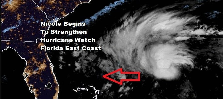
Nicole Forecast to Strengthen Hurricane Watch Florida East Coast
Risk Grows For Heavy Rain Late Friday Into Saturday Northeast
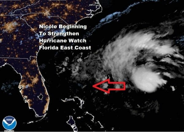
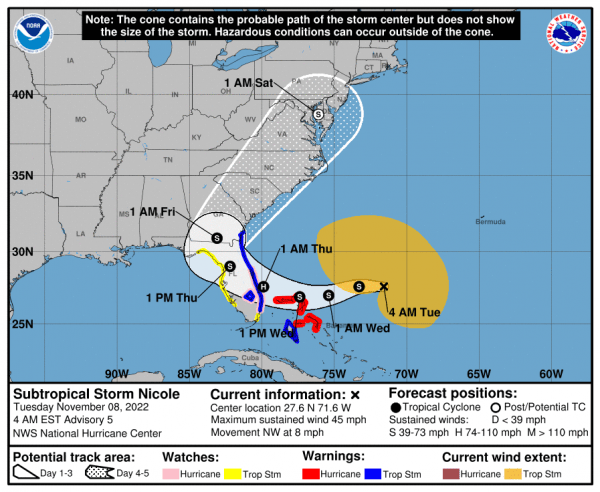
Subtropical Storm Nicole is starting to become bettern organized and we are starting to see the system transition into a warm core tropical cyclone. In the meantime we are also seeing the beginnings of a large dome of high pressure building eastward across the Great Lakes and New England and this high is a rather large piece of this puzzle going forward for the end of the week. Skies are mainly clear on the satellite loops and we have a silent radar and this should be the case for the next couple of days.
SATELLITE

WEATHER RADAR

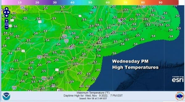
Three remarkable days of record highs have come to a close and now we will see temperatures back to near or even a few degrees below normal over the next day or two. The high will be building southward and that will be creating a strong onshore flow in the Southern Mid Atlantic and South Atlantic states. In the meantime today we will have a large temperature change today with highs in the 50s which will be 20 degrees cooler than what we saw yesterday. We should have plenty of sunshine all day long.
Tonight with clear skies and a north wind. That will take temperatures down with lows inland in the 20s north and west of the coast and middle to upper 30s coast and warmer urban centers.

The high will be in firm control Wednesday with cool temperatures and lots of sunshine. Highs Wednesday will be in the low to mid 50s.
Thursday we begin priming the atmosphere for what will likely be Hurricane Nicole or strong Tropical Storm Nicole as it makes landfall early Thursday along the Florida East Coast. Winds will turn southeast and dew points will begin to rise. We will see sunshine probably giving way to arriving clouds with highs reaching the low and middle 60s.
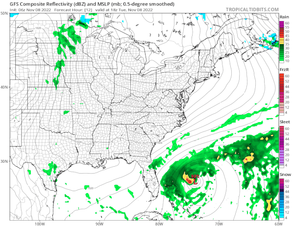
Nicole will make a landfall along the Florida East Coast Thursday. The biggest issue will be a storm surge that extends far north of where the storm landfalls. This is due to the big high to the north creating a tight pressure gradient from North Carolina south. Coastal flooding and beach erosion will be a big deal with this system. Nicole is going to turn sharply northward and then north northeast and move up the coast somewhere east of the Appalachians. This likely brings rain developing from South to north Friday and it will be heavy at times especially west of the track of Nicole. How much rain will depend on whether the core of Nicole survives the trip up the coast or does it get absorbed by the front. Right now we see a good chance that most of the area from Eastern Pennsylvania to Southern New England gets 2 to 3 inches of rain. If the core survives it could be a bit more. The front will sweep the rain offshore early Saturday morning and we will see improving weather conditions afterwards. Longer range looks much colder with below average temperatures settling in next week and it could be a cold pattern that lasts for quite awhile.
…NICOLE BEGINNING TO STRENGTHEN…
…EXPECTED TO TURN WESTWARD OR WEST-SOUTHWESTWARD TODAY…
SUMMARY OF 700 AM EST…1200 UTC…INFORMATION
———————————————-
LOCATION…27.7N 72.0W
ABOUT 385 MI…615 KM ENE OF THE NORTHWESTERN BAHAMAS
MAXIMUM SUSTAINED WINDS…50 MPH…80 KM/H
PRESENT MOVEMENT…WNW OR 300 DEGREES AT 8 MPH…13 KM/H
MINIMUM CENTRAL PRESSURE…992 MB…29.29 INCHES
WATCHES AND WARNINGS
——————–
CHANGES WITH THIS ADVISORY:
None
SUMMARY OF WATCHES AND WARNINGS IN EFFECT:
A Hurricane Warning is in effect for…
* The Abacos, Berry Islands, Bimini, and Grand Bahama Island in the
northwestern Bahamas
A Tropical Storm Warning is in effect for…
* Andros Island, New Providence, and Eleuthera in the northwestern
Bahamas
* Hallandale Beach Florida to Altamaha Sound Georgia
* Lake Okeechobee
A Storm Surge Warning is in effect for…
* North Palm Beach Florida to Altamaha Sound Georgia
* Mouth of the St. Johns River to Georgetown Florida
A Hurricane Watch is in effect for…
* Hallandale Beach to the Volusia/Brevard County Line Florida
* Lake Okeechobee
A Storm Surge Watch is in effect for…
* South of North Palm Beach to Hallandale Beach Florida
A Tropical Storm Watch is in effect for…
* South of Hallandale Beach to north of Ocean Reef Florida
* North of Bonita Beach to the Ochlockonee River Florida
BE SURE TO DOWNLOAD THE FREE METEOROLOGIST JOE CIOFFI WEATHER APP &
ANGRY BEN’S FREE WEATHER APP “THE ANGRY WEATHERMAN!
MANY THANKS TO TROPICAL TIDBITS & F5 WEATHER FOR THE USE OF MAPS
Please note that with regards to any severe weather, tropical storms, or hurricanes, should a storm be threatening, please consult your local National Weather Service office or your local government officials about what action you should be taking to protect life and property.


