Nice Weather Continues Into Wednesday Chance for Storms Late Friday

Nice Weather Continues Into Wednesday Chance for Storms Late Friday
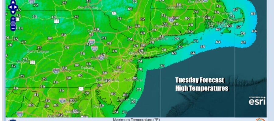
We have another nice day for Tuesday thanks to an upper low in Eastern Canada and a lagging trough heading east. The trough might produce some patchy clouds today as we see the satellite loop showing some clouds to the west moving east. However thunderstorm development is not expected today as the trough is too far east to cause storms to develop. So we will call it no worse than partly sunny for today and high temperatures will reach the mid to upper 70s.
SATELLITE WITH LIGHTNING STRIKES

WEATHER RADAR

Once this last trough moves out to the east, high pressure will settle along the Mid Atlantic coast Wednesday and moving offshore afterwards. This will keep temperatures somewhat in check through Wednesday and then they will start rising. Winds will turn more west southwest with time bringing in warmer air. At first the air overhead being so dry, dew points will only come up slowly and that will keep things comfortable Wednesday and Thursday.

Wednesday should be a lovely day with plenty of sunshine and highs will reach the upper 70s and lower 80s. It will likely be cooler along coastal areas thanks to local sea breezes developing. Thursday will be a little warmer with sunshine for not almost if not all of the day. Highs will be in the low to middle 80s in most places. Again it will likely be cooler along coastal areas thanks to sea breezes.

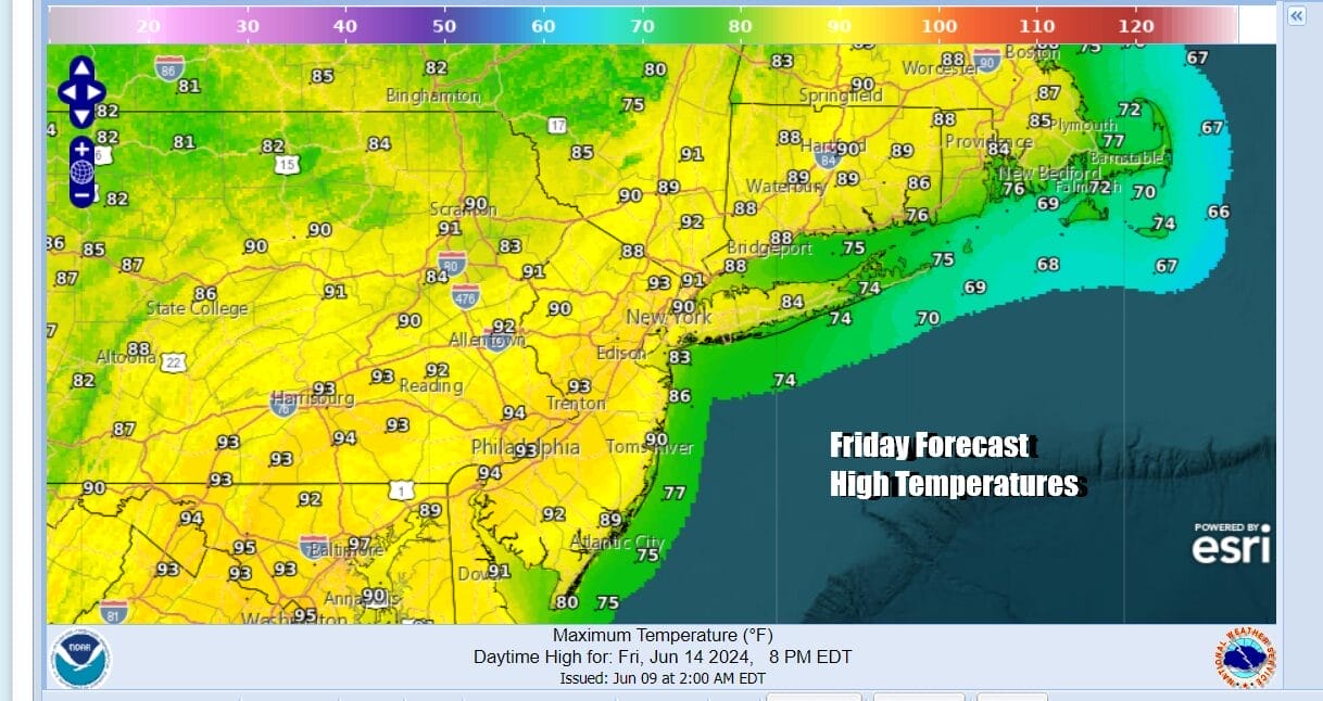
Humidity levels and temperatures will rise Friday ahead of a cold front moving east across the Great Lakes and through the Northeast. The good news is that the front will be keep on moving. That means that once any showers and thunderstorms are done, it will leave us with a lovely Saturday and Sunday which of course is Father’s Day.

Friday we will likely see the first day of 90 degree highs for a large portion of Eastern Pennsylvania to Southern New England. Highs will reach the upper 80s to some lower 90s in general inland and 70s to near 80 off the coast as the southwest wind might cool things down a bit at the coast. Late in the day we will likely see a line of thunderstorms and there is some potential for severe weather risk. We will evaluate this risk Wednesday.
Other than perhaps some leftover clouds early Saturday, we should see plenty of sunshine both Saturday and Sunday and nothing more than some passing clouds from time to time. Humidity levels will be low, We will have a nice north wind for much of the time. High temperatures both days will be in the upper 70s to lower 80s. Next week we see the potential of a stretch of heat and humidity developing with at least a couple of days of highs in the 90s.
BE SURE TO DOWNLOAD THE FREE METEOROLOGIST JOE CIOFFI WEATHER APP &
ANGRY BEN’S FREE WEATHER APP “THE ANGRY WEATHERMAN!
MANY THANKS TO TROPICAL TIDBITS FOR THE USE OF MAPS
Please note that with regards to any severe weather, tropical storms, or hurricanes, should a storm be threatening, please consult your local National Weather Service office or if notyour local government officials about what action you should be taking to protect life and property.
(Amazon is an affilate of Meteorologist Joe Cioffi & earns co


