Nice Sunny Day Warmer Temperatures Weekend Outlook & Long Range

Weather in 5/Joe & Joe Weather Show Latest Podcast
Nice Sunny Day Warmer Temperatures Weekend Outlook & Long Range
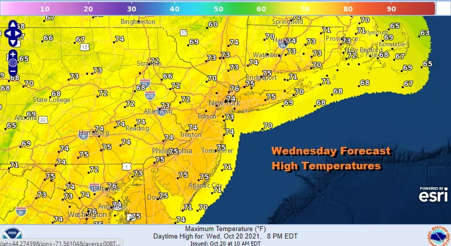
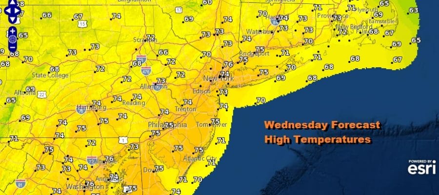
We are enjoying a nice day across the entire region. Mostly cloud free conditions and sunny skies extend pretty much up and down in the Eastern Seaboard with Northern Maine being the exception. The sun should do a good job taking temperatures back into the 70s everywhere today. There are no radar issues at all and we see that remaining the case into Thursday. Skies should be clear tonight with lows in the 50s to near 60.
SATELLITE

WEATHER RADAR

A weak cold front approaches Thursday but the showers with this will go well to the northwest of us. This will lead to another sunny day from Eastern Pennsylvania to Southern New England and everyone in between. Highs again will be in the 70s. The front passes late Thursday night and there is the slight chance that we could see a passing shower.

The front will temporarily get hung up nearby Friday into Saturday as it waits for another front and upper trough to kick it eastward. This leaves us in partly sunny skies for Friday with most highs in the 60s to near 70. The second front will approach on Saturday and that will produce clouds and some scattered showers with highs in the 60s. Behind the front we have some differences in the models for Sunday and we lean to the optimistic solution. The GFS seems to want to push rain eastward from some Pacific energy moving across the US but the European slows that down and builds high pressure southeastward from the Great Lakes making for a nice day but a cool day. We lean toward the latter solution.
This leaves us with a partly sunny but a cool Sunday with highs just in the 50s to around 60. That cool air holds on for Monday with sunshine and highs in the 50s. Next week’s outlook will hinge on the blocky pattern and whether it will allow western energy to move east. This could bring some rain or showers in on Tuesday and another system follows later next week. The block could force the system to pass to the south of us so we will be monitoring those developments in the coming days.
BE SURE TO DOWNLOAD THE FREE METEOROLOGIST JOE CIOFFI WEATHER APP &
ANGRY BEN’S FREE WEATHER APP “THE ANGRY WEATHERMAN!

MANY THANKS TO TROPICAL TIDBITS & F5 WEATHER FOR THE USE OF MAPS
Please note that with regards to any severe weather, tropical storms, or hurricanes, should a storm be threatening, please consult your local National Weather Service office or your local government officials about what action you should be taking to protect life and property.


