Nice Monday Warm 80s with No Rain Tuesday & Wednesday,
Chance for Showers or a Thunderstorm Late Thursday

Nice Monday Warm 80s with No Rain Tuesday & Wednesday,
Chance for Showers or a Thunderstorm Late Thursday
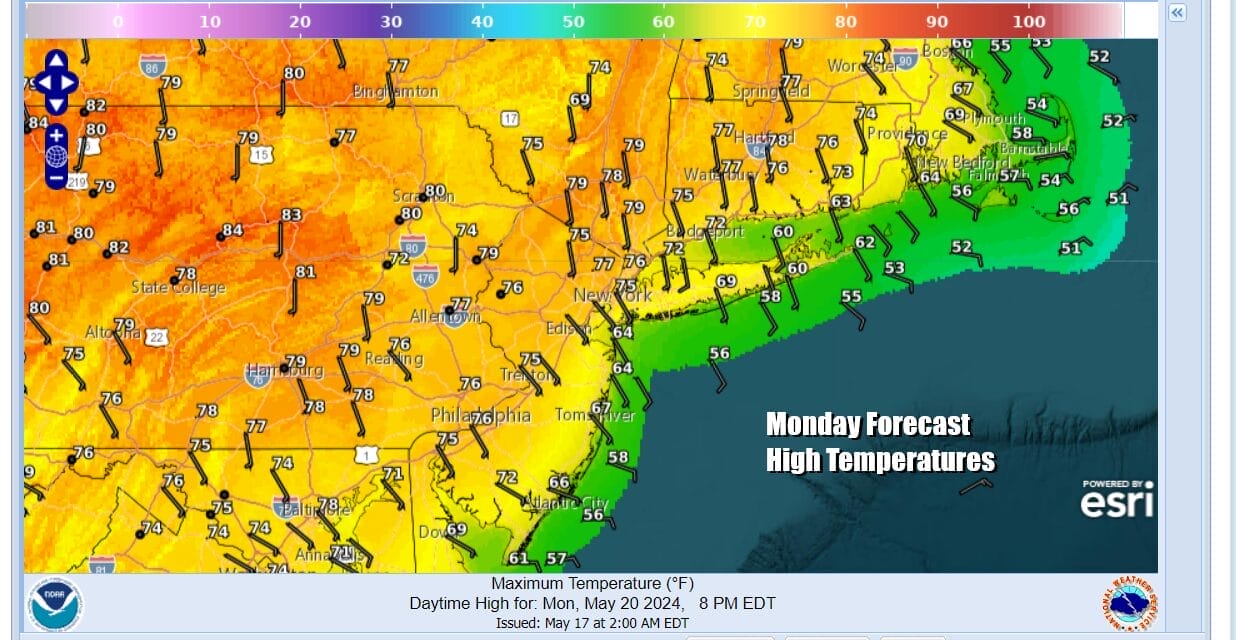
Progress on weather improvement has been slow but we are finally at a place where the weather in the Eastern US will be a dry warmer experience beginning today and lasting through Wednesday. High pressure is slowly repositioning itself along the East Coast. The onshore flow weakens today but it will still be there as a southeast wind to keep temperatures from rising too fast. Inland highs with sunshine will reach the middle to some upper 70s while along the coast, south and east facing shorelines will likely be in the 60s. At least the radars are silent and should remain so for the next 3 days. There is still a bit of cloud cover over Eastern Long Island and Southeastern New England but this should gradually disappear as the day wears on.l
SATELLITE WITH LIGHTNING STRIKES

WEATHER RADAR

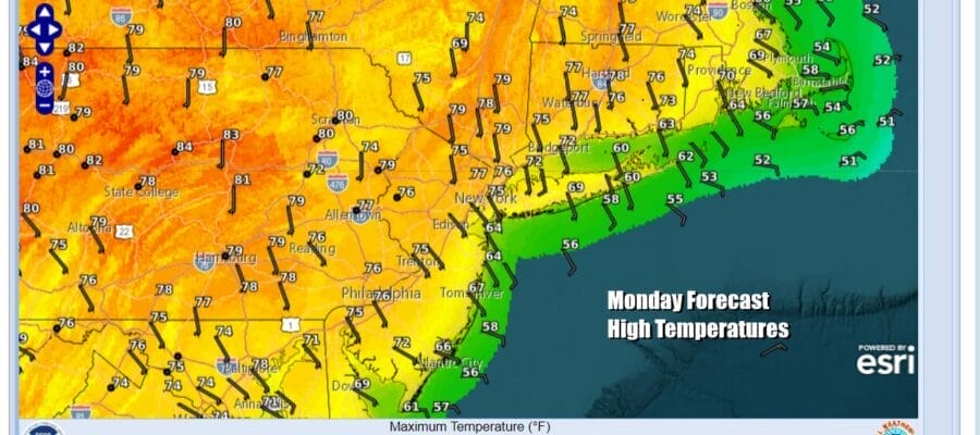
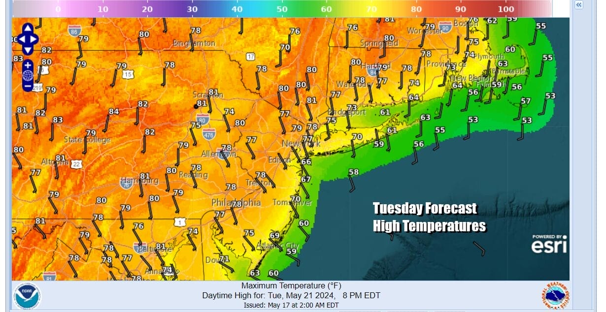
Most lows tonight will be in the 50s with reading closer to 60 in warmer urban sections. Skies will be mainly clear though some patchy low clouds and some fog are possible in some valleys inland and in some coastal areas. Tuesday will be a nice sunny day as winds turn more south and that will allow temperatures to rise into the 80s inland and the 70s along the immediate coast (south and east facing shorelines).
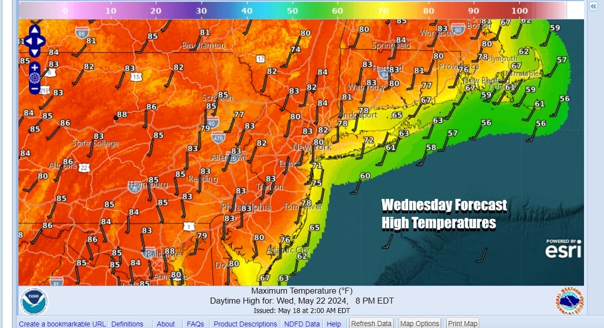
Wednesday should be the day where high pressure anchors off the Virginia coast and winds turn southwest. This cuts off the flow off the ocean to a large extent. Starting off the day in the upper 50s to mid 60s will give us a launching pad. Sunshine Wednesday will take highs well into the 80s inland and mid 70s to lower 80s along the immediate coast. Some warm spots could touch 90 degrees. That would not be a big surprise.
Eventually the ridge in the Eastern US breaks down and that will allow a cold front from a powerful Midwest storm system to head east. This front and storm will reach peak intensity Tuesday and bring widespread severe weather and tornado risk to parts of the Plains and Upper Midwest. We will see a weakened version of this front pass through late Thursday and this is where we put in the chance for some showers and perhaps a thunderstorm or two.

Thursday temperatures will be in the low to middle 80s. As long as the front keeps moving we should see some sunshine back for Friday, getaway day and highs will be in the 70s. As far as the weekend is concerned there are remaining questions regarding chances for rain, and when those chances will be highest. Models seem to be moving back and forth on these issues. We will remain optimistic for Saturday & Sunday but then we run the risk for showers at some point Monday.
BE SURE TO DOWNLOAD THE FREE METEOROLOGIST JOE CIOFFI WEATHER APP &
ANGRY BEN’S FREE WEATHER APP “THE ANGRY WEATHERMAN!
MANY THANKS TO TROPICAL TIDBITS FOR THE USE OF MAPS
Please note that with regards to any severe weather, tropical storms, or hurricanes, should a storm be threatening, please consult your local National Weather Service office or your local government officials about what action you should be taking to protect life and property.
(Amazon is an affilate of Meteorologist Joe Cioffi & earns commissions on sales.)


