Nice Finish to the Work Week
Mostly Dry This Weekend With Shower Chances Late Sunday

Nice Finish to the Work Week
Mostly Dry This Weekend With Shower Chances Late Sunday
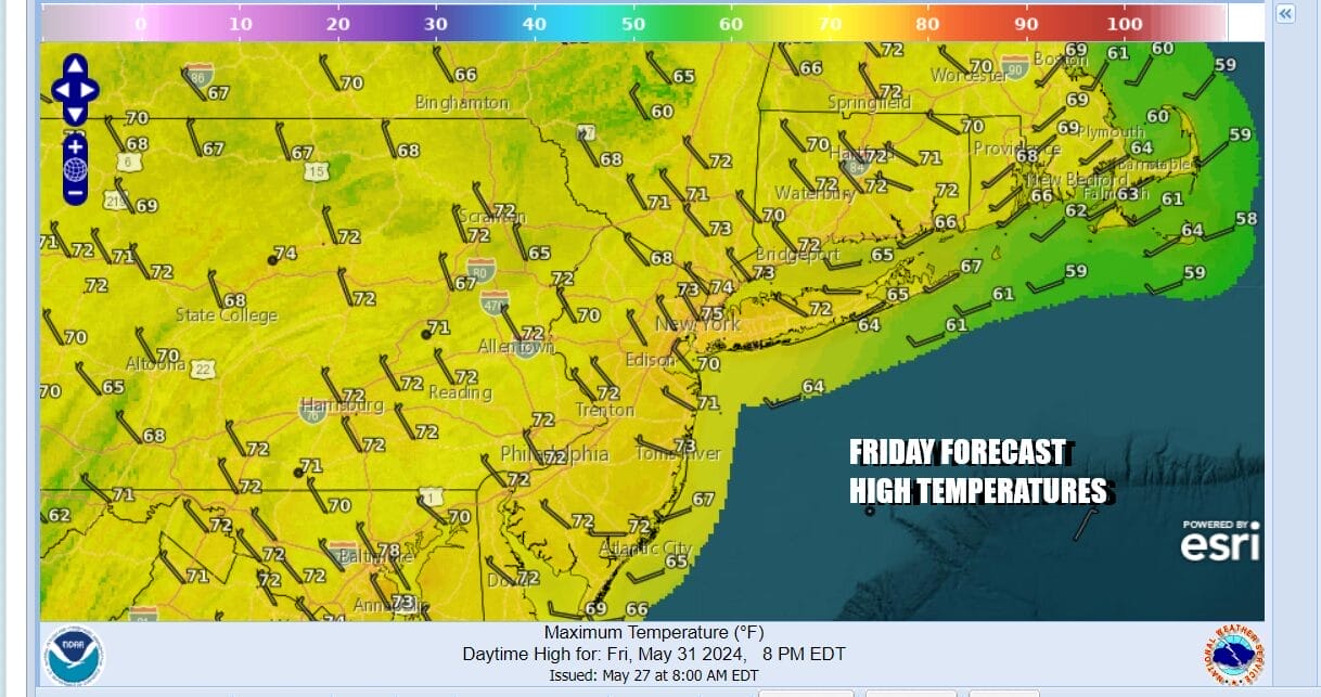
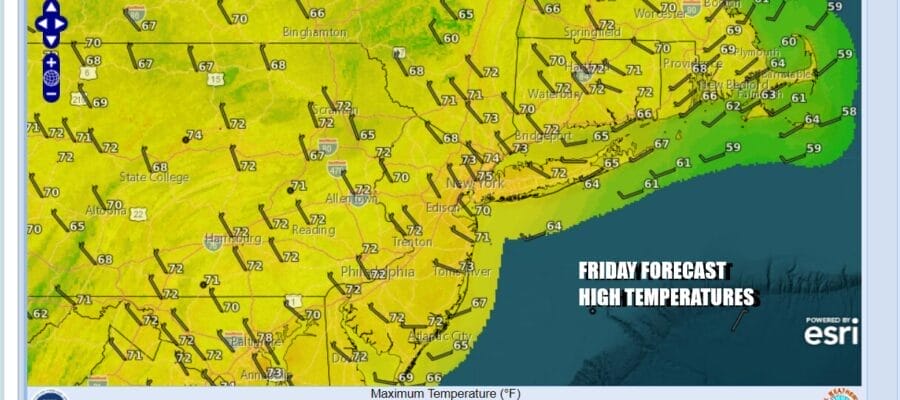
We have arrived at the doorstep of the weekend and we are starting off the day with rather cool temperatures but we have a satellite loop that shows nice clear skies up and down the Eastern Seaboard. High pressure covers much of the Eastern US today and tonight so we will have plenty of sunshine today with a mostly northwest breeze and highs reaching the low to middle 70s in most places. Radars are nice and quiet and we have no rain issues to deal with.
SATELLITE WITH LIGHTNING STRIKES

WEATHER RADAR

We have seen rain on at least one weekend day for 16 straight weekends which basically takes us back to some time in February. Will this streak break this weekend? Well we have to put the chance for scattered showers in the forecast for possibly late Sunday into Sunday evening. Severe weather is in the middle of the US and a weak system breaks away to the northeast over the weekend.

The system is going to weaken as it moves eastward but it might bring through some scattered showers late Sunday afternoon into Sunday evening. I don’t expect the rainfall to amount to much and in fact, it is possible that the system could weaken enough so that we don’t see showers at all. In the meantime Saturday uis a good day with sunshine and highs reaching the middle to upper 70s with some warm spots hitting 80 or so.

Sunday we will call it a day of sunshine giving way to arriving clouds and we will throw in the chance for some scattered showers later in the day into Sunday evening. Highs Sunday should reach the upper 70s to lower 80s inland and it will be cooler along south and east facing shore lines thanks to a south wind. Next week looks to start off dry into Wednesday and though the flow will be somewhat onshore, it should still warm up into the 80s away from the ocean. The next important weather front may not reach the Northeast and Middle Atlantic until next Wednesday night or Thursday. Have a great weekend.
BE SURE TO DOWNLOAD THE FREE METEOROLOGIST JOE CIOFFI WEATHER APP &
ANGRY BEN’S FREE WEATHER APP “THE ANGRY WEATHERMAN!
MANY THANKS TO TROPICAL TIDBITS FOR THE USE OF MAPS
Please note that with regards to any severe weather, tropical storms, or hurricanes, should a storm be threatening, please consult your local National Weather Service office or your local government officials about what action you should be taking to protect life and property.
(Amazon is an affilate of Meteorologist Joe Cioffi & earns commissions on sales.)


