
New Jersey NYC Long Island Hudson Valley Warmer Temperatures
No Rain Through Saturday But Some Showers Possible Sunday

New Jersey NYC Long Island Hudson Valley Warmer Temperatures
No Rain Through Saturday But Some Showers Possible Sunday

We are moving along in a rain free week with another day of sunshine however there are some high clouds blowing off from weather systems moving eastward from the Northern Great Lakes to Northern New England and Southeastern Canada so let’s call today sunshine with some high clouds. Temperatures will continue their upward march and highs will reach the upper 60s and lower 70s this afternoon. Radars are picking up on some scattered showers in Upstate NY and Northern New England as well as in Western Pensylvania but they are not going to be an issue in Eastern Pennsylvania to Southern New England. Nights are going to start to get warmer as well with Thursday morning lows in the upper 40s inland and low to mid 50s just about every where else.
SATELLITE WITH LIGHTNING STRIKES

WEATHER RADAR

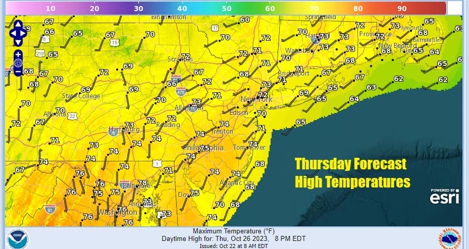
High pressure off the Mid Atlantic coast is going no where fast as it is pinned there by Hurricane Tammy, which is south of Bermuda with 100 mph winds and moving slowly northward. As long as it sits out there, and it will for another couple of days, the high can’t move so that keeps nice weather going. Thursday again will be a day of sunshine and some patchy high clouds. Thursday highs will be in the low to middle 70s.
We will be in a bit more of a sweet spot Friday with high pressure to the south and southeast and more of a west wind developing. This should lead us to sunshine and temperatures nudging a bit higher. Highs Friday afternoon will be in the middle to upper 70s in most places.

Over the weekend the upper high will be breaking down and that will start to allow weather systems that have been pinned to our west with storm tracks from the Plains to the Great Lakes to finally make some headway into the Eastern US. A cold front will approach Saturday and then push close enough so that we get some showers coming in for Sunday morning.

This leaves us with a very warm day Saturday with sunshine for much of the day. Given that the launching pad for temperatures will be rather high Saturday morning as we start the day in the 50s and 60s, we could see record high temperatures in the upper 70s and lower 80s Saturday afternoon.

We are looking for some showers to move through later Saturday night into Sunday morning but those showers will be ending from west to east during the morning, leaving us in lots of clouds for Sunday afternoon. The cold front stalls overhead and we need to wait for another wave of low pressure to develop and push the front through. Sunday highs will be lower but still warm for this time of year with highs mostly in the upper 60s and lower 70s.

More showers will move Sunday night and for much of Monday as the second wave goes by. This will move the front offshore and a much colder air mass will be moving in for Monday night and lasting through Wednesday. This is a cold air mass and it will take temperatures down by about 20 degrees or more from this week. It will be dry Tuesday for Halloween but it will be cold with highs just into the 50s and Tuesday night we could see freezes inland.
BE SURE TO DOWNLOAD THE FREE METEOROLOGIST JOE CIOFFI WEATHER APP &
ANGRY BEN’S FREE WEATHER APP “THE ANGRY WEATHERMAN!
MANY THANKS TO TROPICAL TIDBITS FOR THE USE OF MAPS
Please note that with regards to any severe weather, tropical storms, or hurricanes, should a storm be threatening, please consult your local National Weather Service office or your local government officials about what action you should be taking to protect life and property.
(Amazon is an affilate of Meteorologist Joe Cioffi & earns commissions on sales.)


