Nate Rains Arrive Monday
SHOP THE JOESTRADAMUS STORE
Nate Rains Arrive Monday
Another warm humid day lies ahead of us but we do have a frontal system approaching which is going to produce a few passing showers. As usual with these things lately they look impressive on the satellite to the west and then they fall apart to some degree before they reach us. Otherwise today it will be low clouds and fog to start in some places and then clouds with just some limited sun and temperatures in the 70s to near 80. Hurricane Nate came inland nd is now moving north northeastward from Mississippi and the rain from Nate will be with us on Monday.
SATELLITE LOOP

REGIONAL RADAR

LOCAL RADAR NEW YORK CITY

LOCAL RADAR PHILADELPHIA


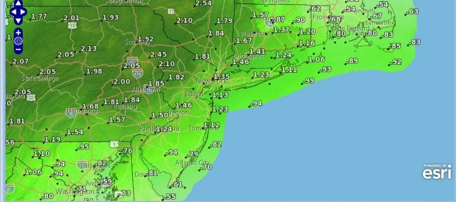
Rain from Nate arrives in areas to the west and north late tonight and elsewhere during the day on Monday. As far as rain totals are concerned we are looking at 1 to 2 inches of rain with more as you go west and north into Pennsylvania and Upstate NY & less as you head into South Jersey southward.

This should all be done by Monday night. Weather conditions will improve on Tuesday with some sun and clouds with highs in the 70s to near 80. It should turn cooler Wednesday and Thursday with an onshore wind and highs just into the 70s.
 GET JOE A CIGAR IF YOU LIKE

FiOS1 News Weather Forecast For Long Island
FiOS1 News Weather Forecast For New Jersey
FiOS1 News Weather Forecast For Hudson Valley


