
NAM Model Backs Off Strongly

MENTION JOE CIOFFI AND GET A 5% DISCOUNT
For much of this week I have been taking a stand against this entire event for a whole host of reasons. But the most important reason was the fact that all winter long we have seen numerous instances where models wanted to create vigorous systems to move up the east coast only to result in an entirely different upper air profile.
This event is no different. Since the NAM model and the Euro model have been running pretty close to each other, my suspicion is that the Euro model will be no different this afternoon when it comes out.
NAM Model Backs Off Strongly Surface Maps
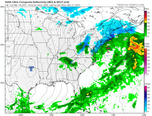

Here are the new nam surface maps for Sunday evening 8pm and Sunday overnight 2am. This is a marked difference from yesterday and last night. Instead of having an intensifying cyclone heading for Nantucket with heavy snows to the coast we have a flatter much less intense system that is faster and already moving away. Why is this the case? The upper air maps show us.
NAM Model Backs Off Strongly UPPER AIR MAPS YESTERDAY VS TODAY
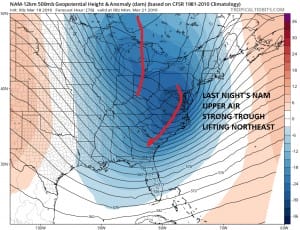
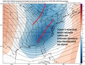
The difference between last night’s NAM model run and today’s run 12 hours later is astounding. This is EXACTLY the same thing we have seen with other systems other than the blizzard. In fact the blizzard was the only instance where it actually played out to the more intense solution. The upper air structure is completely different. Rather than having an intense feature lifting up and around the northern part of the jet stream, the last 2 nam model runs keep the streams completely separate. In fact the southern feature stays completly separate and just moves along and offshore. If this is the case the bulk of any precipitation falls during the day Sunday into Sunday evening and then it is done. At most you might see out of this is a coating to a few inches and maybe only on colder surfaces since the bulk of the precipitation falls during the day on Sunday.
NAM Model Backs Off Strongly NAM TOTAL PRECIPITATION FORECAST
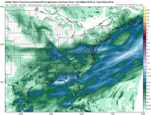
NAM total precipitation amounts have been cut by more than half with barely a half inch of liquid in places where previously they got more than double or in some cases even triple that amount. Based on this model run I could not go for more than a coating to a few inches…if that!!! My suspicion is that the European will come in and do the same thing. If the upper air structure on this is the same on the Euro model, then this system IS NOT GOING TO BE A BIG DEAL.
FiOS1 News Weather Forecast For Long Island
FiOS1 News Weather Forecast For New Jersey
FiOS1 News Weather Forecast For Hudson Valley
NATIONAL WEATHER SERVICE SNOW FORECASTS
LATEST JOESTRADAMUS ON THE LONG RANGE

NOMINATED FOR AN APPY AWARD FOR BEST WEATHER APP!!
Weather App

Don’t be without Meteorologist Joe Cioffi’s weather app. It is really a meteorologist app because you get my forecasts and my analysis and not some automated computer generated forecast based on the GFS model. This is why your app forecast changes every 6 hours. It is model driven with no human input at all. It gives you an icon, a temperature and no insight whatsoever.
It is a complete weather app to suit your forecast needs. All the weather information you need is right on your phone. Android or I-phone, use it to keep track of all the latest weather information and forecasts. This weather app is also free of advertising so you don’t have to worry about security issues with your device. An accurate forecast and no worries that your device is being compromised.
Use it in conjunction with my website and my facebook and twitter and you have complete weather coverage of all the latest weather and the long range outlook. The website has been redone and upgraded. Its easy to use and everything is archived so you can see how well Joe does or doesn’t do when it comes to forecasts and outlooks.
Just click on the google play button or the apple store button on the sidebar for my app which is on My Weather Concierge. Download the app for free. Subscribe to my forecasts on an ad free environment for just 99 cents a month.
Get my forecasts in the palm of your hand for less than the cost of a cup of Joe!
![]()


