Matthew Rains Coastal NJ & Long Island
Matthew Rains Coastal NJ & Long Island
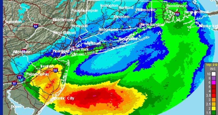
It is turned into a very sloppy Sunday across coastal areas as the cold front is combining with Post Tropical Cyclone Matthew to produce some significant 1 to 2 inch rains on average over Central & Southern New Jersey northeast to NYC, Coastal Connecticut, and Long Island. Storm estimates on the radar show some 2 inch plus amounts over parts of Central and Southern New Jersey.
MATTHEW RAINS STORM TOTALS AS OF 1PM EDT SUNDAY 10092016
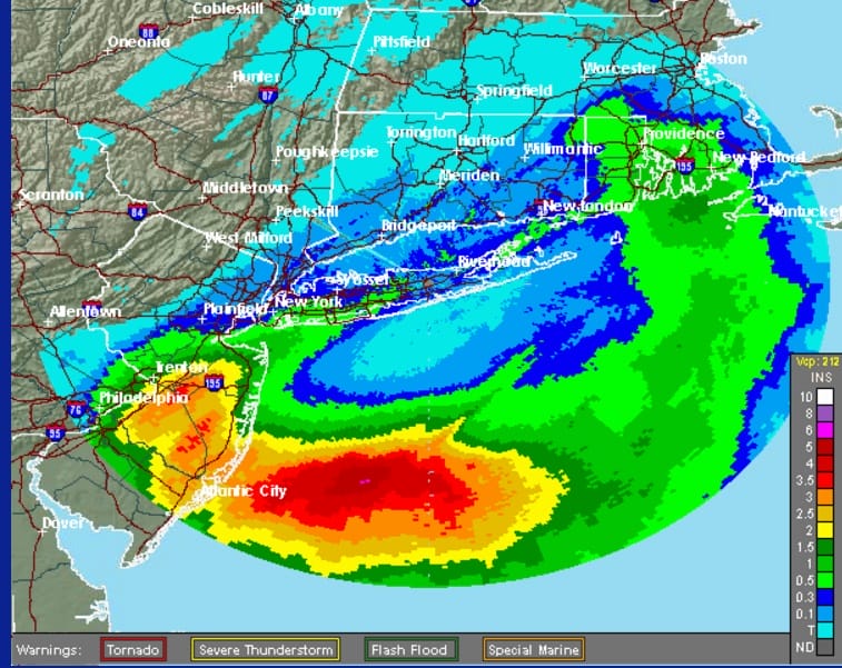
Some specific rainfall amounts measured at local reporting stations so far show rain in the 1 to 2 inch range over a large area. These are rainfall amounts as of 1pm EDT.
MATTHEW RAINS MEASURED STORM TOTALS AS OF 1PM EDT SUNDAY 10092016
 The satellite loop shows Matthew taking the appearance of a nor’easter as the low center continues to move eastward. Dry air is moving into Western New Jersey and Western Hudson Valley areas but that will not reach the coast until probably this evening or tonight.

Radars are still rather busy showing light to moderate rain still hugging the coast. At least some of the drought areas did well today especially Long Island and parts of Southern New England.


Going forward weather conditions will continue to improve from west to east. Skies will clear out tonight and Monday looks like a nice Columbus Day with sunshine and highs in the cool low to mid 60s. Going forward this week it looks to be dry and seasonal all week long.
WINTER WEATHE OUTLOOK VIDEOS
In case you missed them I’ve been previewing the upcoming winter in a series of posts and videos. Here are the first 2. More will be coming along. Links to the latest posts are below.
NEW JERSEY
LONG ISLAND AND NEARBY
WINTER 2016-2017 PART 3 NEW JERSEY
WINTER 2016-2017 PART 1 OCEAN WATER TEMPERATURES
WINTER 2016-2017 PART 2 ARCTIC SEA ICE AND SIBERIAN SNOW COVER
FiOS1 News Weather Forecast For Long Island
FiOS1 News Weather Forecast For New Jersey
FiOS1 News Weather Forecast For Hudson Valley
NATIONAL WEATHER SERVICE SNOW FORECASTS
LATEST JOESTRADAMUS ON THE LONG RANGE

Weather App

Don’t be without Meteorologist Joe Cioffi’s weather app. It is really a meteorologist app because you get my forecasts and my analysis and not some automated computer generated forecast based on the GFS model. This is why your app forecast changes every 6 hours. It is model driven with no human input at all. It gives you an icon, a temperature and no insight whatsoever.
It is a complete weather app to suit your forecast needs. All the weather information you need is right on your phone. Android or I-phone, use it to keep track of all the latest weather information and forecasts. This weather app is also free of advertising so you don’t have to worry about security issues with your device. An accurate forecast and no worries that your device is being compromised.
Use it in conjunction with my website and my facebook and twitter and you have complete weather coverage of all the latest weather and the long range outlook. The website has been redone and upgraded. Its easy to use and everything is archived so you can see how well Joe does or doesn’t do when it comes to forecasts and outlooks.
Just click on the google play button or the apple store button on the sidebar for my app which is on My Weather Concierge. Download the app for free. Subscribe to my forecasts on an ad free environment for just 99 cents a month.
Get my forecasts in the palm of your hand for less than the cost of a cup of Joe!

MENTION JOE CIOFFI AND GET A 5% DISCOUNT


