Hurricane Matthew North Carolina Moves Offshore
Hurricane Matthew North Carolina Flooding
Hurricane Matthew Moves Center Moves Offshore
Normally with a hurricane moving offshore we would begin to see some slow improvement but this is not the cast in North Carolina. The transition from a purely tropical system to an extra tropical or post tropical system has created a very severe flooding situation tonight across North Carolina.

You can see the center is clearly offshore south of Wilmington North Carolina. However as Matthew takes on the characteristics of a non tropical storm, the shield of heavy rain has shifted to well north and west of the center. When you see the radars below the eastern half of North Carolina is completely coverered with heavy rains and the possibility of tornadoes.


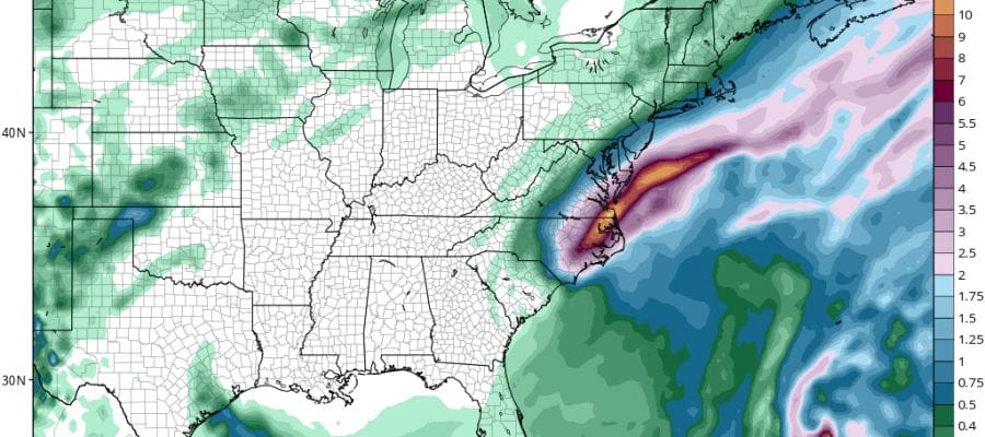
Meanwhile the northern edge of the rain has reached coastal areas as it rides northward along an approaching front. Much of that rain remains light with heavier rains from Delaware southward and that shoudl continue overnight. The GFS is forecasting another 6 to 10 inches of rain possible in the next 12 hours.

Some areas in Central and Southern New Jersey and Eastern Long Island could squeeze out a quarter to a half inch out of this.
HURRICANE MATTHEW NORTH CAROLINA LATEST ADVISORY
BULLETIN
HURRICANE MATTHEW ADVISORY NUMBER  43
NWS NATIONAL HURRICANE CENTER MIAMI FL       AL142016
500 PM EDT SAT OCT 08 2016

...TORRENTIAL RAINS SPREADING INLAND ACROSS THE CAROLINAS WHILE
MATTHEW HUGS THE COAST...


SUMMARY OF 500 PM EDT...2100 UTC...INFORMATION
----------------------------------------------
LOCATION...33.8N 78.2W
ABOUT 15 MI...20 KM WSW OF CAPE FEAR NORTH CAROLINA
ABOUT 105 MI...170 KM WSW OF CAPE LOOKOUT NORTH CAROLINA
MAXIMUM SUSTAINED WINDS...75 MPH...120 KM/H
PRESENT MOVEMENT...ENE OR 70 DEGREES AT 13 MPH...20 KM/H
MINIMUM CENTRAL PRESSURE...977 MB...28.85 INCHES


WATCHES AND WARNINGS
--------------------
CHANGES WITH THIS ADVISORY:

The Hurricane Warning from South Santee River southward has been
discontinued.

SUMMARY OF WATCHES AND WARNINGS IN EFFECT:

A Hurricane Warning is in effect for...
* North of South of Santee River to Surf City

A Hurricane Watch is in effect for...
* North of Surf City to Cape Lookout

A Tropical Storm Warning is in effect for...
* North of Surf City to Duck
* Pamlico and Albemarle Sounds

For storm information specific to your area, including possible
inland watches and warnings, please monitor products issued by your
local National Weather Service forecast office.


DISCUSSION AND 48-HOUR OUTLOOK
------------------------------
At 500 PM EDT (2100 UTC), the center of Hurricane Matthew was
located near latitude 33.8 North, longitude 78.2 West. Matthew is
moving toward the east-northeast near 13 mph (20 km/h), and this
motion is expected to continue tonight and early Sunday. On the
forecast track, the center of Matthew will be near the coast of
southern North Carolina by this evening.

Maximum sustained winds remain near 75 mph (120 km/h) with higher
gusts.  Although weakening is forecast during the next 48 hours,
Matthew is expected to remain near hurricane strength while the
center is near the coasts of North Carolina.

Hurricane-force winds extend outward up to 25 miles (35 km) mainly
over water to the east of the center.  Tropical-storm-force winds
extend outward up to 185 miles (295 km). Multiple private weather
stations along the coast of South Carolina near Myrtle Beach have
recently reported hurricane-force wind gusts.

The minimum central pressure estimated from Air Force aircraft data
is 977 mb (28.85 inches). CORMP buoy 41024 near the center also
reported a minimum pressure of 977.8 mb (28.87 inches).


HAZARDS AFFECTING LAND
----------------------
WIND:  Hurricane and tropical storm conditions are expected to
continue over the warning area this afternoon, and spread northward
elsewhere within the warning area through tonight.

Hurricane conditions are possible within the Hurricane Watch and
Tropical Storm Warning area in North Carolina by tonight or Sunday
morning, with tropical storm conditions expected later tonight.

STORM SURGE:  The combination of a dangerous storm surge, the tide,
and large and destructive waves will cause normally dry areas near
the coast to be flooded by rising waters moving inland from the
shoreline.  The water could reach the following heights above ground
if the peak surge occurs at the time of high tide...

Murrells Inlet, South Carolina, to Duck, North Carolina, including
portions of the Pamlico and Albemarle Sounds...3 to 5 ft

Along the Georgia and South Carolina coasts southwest of Matthew's
center, inundation caused by Matthew's storm surge will slowly
recede today.

The deepest water will occur along the immediate coast in areas of
onshore winds.  Surge-related flooding depends on the relative
timing of the surge and the tidal cycle, and can vary greatly over
short distances.  Large waves generated by Matthew will cause water
rises to occur well in advance of and well away from the track of
the center.  For information specific to your area, please see
products issued by your local National Weather Service forecast
office.

There is a danger of life-threatening inundation during the next 36
hours along the coast from Murrells Inlet, South Carolina to Salvo,
North Carolina including portions of the Pamlico Sound.  There is
the possibility of life-threatening inundation during the next 48
hours from Salvo to Duck, North Carolina including portions of the
Albemarle Sound. For a depiction of areas at risk, please see the
Prototype National Weather Service Storm Surge Watch/Warning
Graphic. For information specific to your area, please see products
issued by your local National Weather Service forecast office.

The Prototype Storm Surge Watch/Warning Graphic is a depiction of
areas that would qualify for inclusion under a storm surge watch or
warning currently under development by the National Weather Service
and planned for operational use in 2017.  The Prototype Graphic is
available at hurricanes.gov.

RAINFALL: Matthew is expected to produce total rain accumulations of
8 to 12 inches from northeast South Carolina into northeast North
Carolina and southeast Virginia, with possible isolated totals of 20
inches possible. This rainfall may result in life-threatening
flooding and flash flooding.

TORNADOES:  A couple of tornadoes are possible this afternoon along
the coast of North Carolina.

SURF:  Swells generated by Matthew will continue to affect much of
the coast of the southeastern United States through early next week.
These swells will likely cause life-threatening surf and rip current
conditions. Please consult products from your local weather office.
WINTER WEATHER OUTLOOK VIDEOS
In case you missed them I’ve been previewing the upcoming winter in a series of posts and videos. Here are the first 2. More will be coming along. Links to the latest posts are below.
NEW JERSEY
LONG ISLAND AND NEARBY
WINTER 2016-2017 PART 3 NEW JERSEY
WINTER 2016-2017 PART 1 OCEAN WATER TEMPERATURES
WINTER 2016-2017 PART 2 ARCTIC SEA ICE AND SIBERIAN SNOW COVER
FiOS1 News Weather Forecast For Long Island
FiOS1 News Weather Forecast For New Jersey
FiOS1 News Weather Forecast For Hudson Valley
NATIONAL WEATHER SERVICE SNOW FORECASTS
LATEST JOESTRADAMUS ON THE LONG RANGE

Weather App

Don’t be without Meteorologist Joe Cioffi’s weather app. It is really a meteorologist app because you get my forecasts and my analysis and not some automated computer generated forecast based on the GFS model. This is why your app forecast changes every 6 hours. It is model driven with no human input at all. It gives you an icon, a temperature and no insight whatsoever.
It is a complete weather app to suit your forecast needs. All the weather information you need is right on your phone. Android or I-phone, use it to keep track of all the latest weather information and forecasts. This weather app is also free of advertising so you don’t have to worry about security issues with your device. An accurate forecast and no worries that your device is being compromised.
Use it in conjunction with my website and my facebook and twitter and you have complete weather coverage of all the latest weather and the long range outlook. The website has been redone and upgraded. Its easy to use and everything is archived so you can see how well Joe does or doesn’t do when it comes to forecasts and outlooks.
Just click on the google play button or the apple store button on the sidebar for my app which is on My Weather Concierge. Download the app for free. Subscribe to my forecasts on an ad free environment for just 99 cents a month.
Get my forecasts in the palm of your hand for less than the cost of a cup of Joe!

MENTION JOE CIOFFI AND GET A 5% DISCOUNT