
Major Storms Pound West Blow Torch Pattern East
Major Storms Pound West Blow Torch Pattern East
We enjoyed another day of sunshine and warm temperatures across much of the Northeast and Middle Atlantic states with highs in the 50s and 60s everywhere. We are going to see a third day of sunshine and temperatures in the 50s…areas north and west will be primarily in the mid to upper 40s. While cooler than the last few days it is still almost 8-10 degrees above average in some areas.
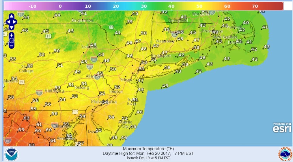
The warmth of the last 2 days eradicated most of the snow cover except in shaded areas but that will be taken care of in short order. It is still hard to believe that we have gone from a Blizzard 9 days ago in some areas to 60s but such is the pattern that has been around all winter. It looks to me that unless something radically changes, it may finish off that way as well
The satellite loop shows clouds moving across Southeastern Canada as a weak front has passed through our area with little fanfare. High pressure builds to the north tonight and Monday.
SATELLITE LOOP

REGIONAL RADAR

There is no rain on the radar to worry about into Tuesday. Another front approaches Tuesday but again this is going to be weak with just a passing shower or two with that late Tuesday afternoon and evening. The air behind the front is mild so we could be back into the 60s for Wednesday and Thursday until a stronger front arrives late this week.
In the west it will be major storm after major storm along with colder temperatures eventually extending down all the way to Southern California. The next two weeks will see a series of major storms in the West that will put a nail in the coffin of the 5 year drought in California. Some of those storms may eventually track toward the Great Lakes and Northeast but they will track west of us which means warm air and rain when they come. Right now it would appear that there is no chance for snow anytime through the rest of this month and first few days of March
 GET JOE A CIGAR IF YOU LIKE

SNOW REMOVAL COMPANIES FOR YOUR WINTER NEEDS
LONG ISLAND ROCKLAND COUNTY Connecticut

![]()

ROCKLAND COUNTY TRI STATE SNOW REMOVAL JOHNSTOWN PA


FiOS1 News Weather Forecast For Long Island
FiOS1 News Weather Forecast For New Jersey
FiOS1 News Weather Forecast For Hudson Valley
NATIONAL WEATHER SERVICE SNOW FORECASTS
LATEST JOESTRADAMUS ON THE LONG RANGE
Weather App

Don’t be without Meteorologist Joe Cioffi’s weather app. It is really a meteorologist app because you get my forecasts and my analysis and not some automated computer generated forecast based on the GFS model. This is why your app forecast changes every 6 hours. It is model driven with no human input at all. It gives you an icon, a temperature and no insight whatsoever.
It is a complete weather app to suit your forecast needs. All the weather information you need is right on your phone. Android or I-phone, use it to keep track of all the latest weather information and forecasts. This weather app is also free of advertising so you don’t have to worry about security issues with your device. An accurate forecast and no worries that your device is being compromised.
Use it in conjunction with my website and my facebook and twitter and you have complete weather coverage of all the latest weather and the long range outlook. The website has been redone and upgraded. Its easy to use and everything is archived so you can see how well Joe does or doesn’t do when it comes to forecasts and outlooks.
Just click on the google play button or the apple store button on the sidebar for my app which is on My Weather Concierge. Download the app for free. Subscribe to my forecasts on an ad free environment for just 99 cents a month.
Get my forecasts in the palm of your hand for less than the cost of a cup of Joe!


