Major Storm Sunday Into Monday
Heavy Rain Strong Winds Flood & High Wind Watches & Wind Advisories

Major Storm Sunday Into Monday
Heavy Rain Strong Winds Flood & High Wind Watches & Wind Advisories
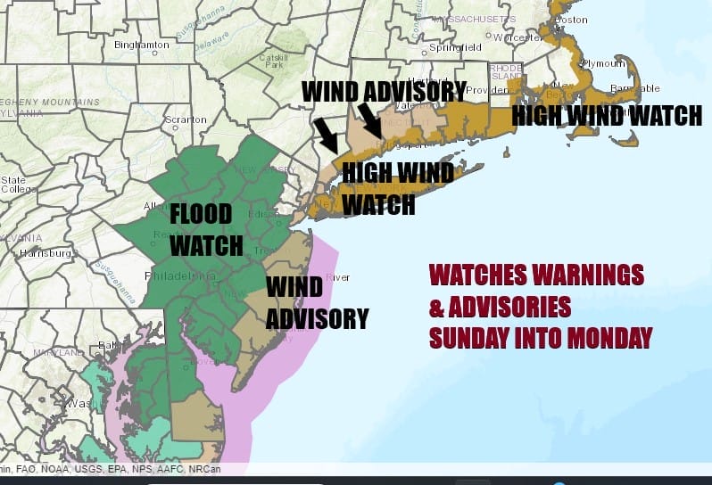
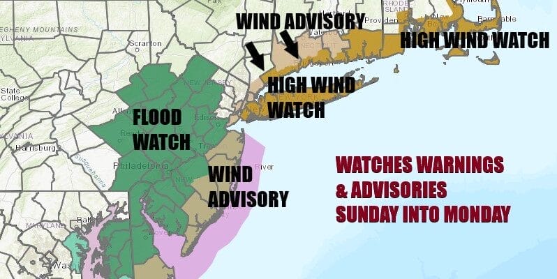
We have a major storm heading up the East Coast from the Gulf of Mexico and the first watches and advisories are up. Flood Watches are up for most of Eastern Pennsylvania and New Jersey except (for now) the Northeastern Counties. Wind Advisories are up for the Coastal New Jersey counties as well as the counties surrounding NYC as well as parts of interior Southern New England. High Wnid Watches up are for Long Island east to Coastal Southeastern New England.
SATELLITE WITH LIGHTNING STRIKES

WEATHER RADAR

Other than some high clouds coming in from the west as well as from the south, much of today should be partly to even mostly sunny across Eastern Pennsylvania to Southern New England with high temperatures this afternoon reaching the 50s. We have high pressure building across Southeastern Canada and New England that is setting the table for a strong onshore east to southeast flow beginning later today. That will be priming up the atmosphere with lots of moisture.

At the same time we have a deep upper air trough moving across the Ohio and Tennessee Valley and another trough dropping southward from Eastern Canada phasing with the southern system The result is a developing low in the Eastern Gulf of Mexico. Heavy drought breaking rains of several inches will spread through the Carolinas and into Virginia tonight into Sunday morning. The storm crosses Florida where we will see severe weather today and tonight with thunderstorms and then straddles the Carolinas. From there is continues the coastal straddle through the Mid Atlantic and then tracking to Coastal New Jersey Monday and into New England Monday afternoon. The storm strengthens along the way to a major storm.

Rainfall develops from south to north in Eastern Pennsylvania to Southern New England from late morning across Southern New Jersey and Southern Pennsylvania to mid and late afternoon when it reaches New England. Then it is heavy rain overnight into Monday morning. 2 to 3 inches of rainfall will be common in most places and that is the reason for the flood watch. As for the wind, once again wind gusts will be strongest along the coast and less of an issue inland.
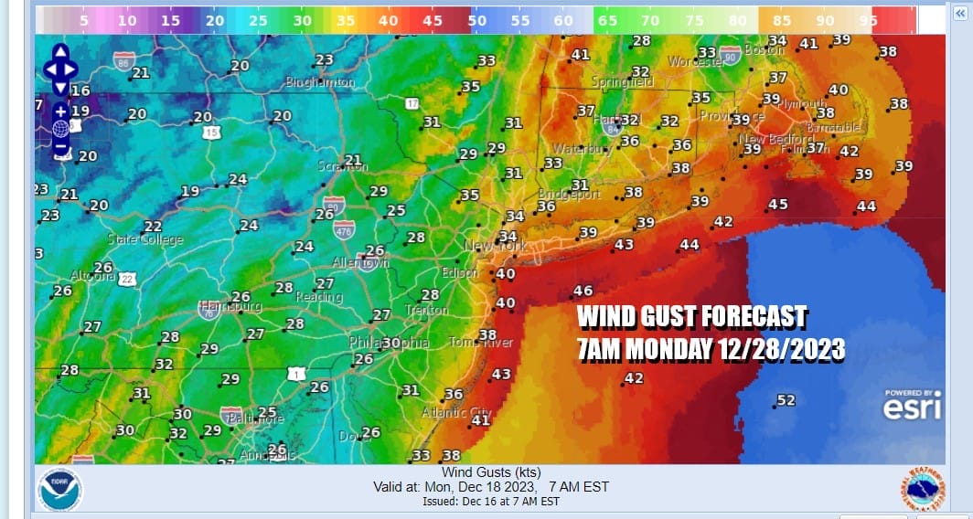
The strongest winds will be overnight Sunday into Monday afternoon and gusts will be in the 40 to 50 mph range along the coast and 20 to 35 with the occasional gust near 40 inland. We will need to monitor whether additional flood watches and wind advisories will be needed and I suspect that we will at least see additional flood watches going up. The storm will be moving into New England Monday afternoon so the rains should end from south to north during Monday morning and then it will be windy and turn colder for Monday night into the middle of next week as weather conditions improve. Sunday temperatures will be in the 50s. Monday will have leftover highs in the 50s early until winds shift to the northwest as the storm center goes by. Later next week we look to have calm weather conditions and after a chilly stretch into Wednesday, we should see temperatures bounce higher toward the end of the week.
BE SURE TO DOWNLOAD THE FREE METEOROLOGIST JOE CIOFFI WEATHER APP &
ANGRY BEN’S FREE WEATHER APP “THE ANGRY WEATHERMAN!
MANY THANKS TO TROPICAL TIDBITS FOR THE USE OF MAPS
Please note that with regards to any severe weather, tropical storms, or hurricanes, should a storm be threatening, please consult your local National Weather Service office or your local government officials about what action you should be taking to protect life and property.
(Amazon is an affilate of Meteorologist Joe Cioffi & earns commissions on sales.)


