Major Storm For Great Lakes

Major Storm For Great Lakes
After looking hard at today’s weather models it seems a good bet that a major storm is indeed going to head of the Great Lakes Tuesday an Wednesday of next week. This is significant in that this is the first time we have see a storm of great intensity all winter long anywhere in the Eastern US this winter. This storm is likely to produce heavy snow for the northern Great Lakes area and there could be some significant snow in parts of Northern New England and upstate NY before any change to ice and rain there. For us it is going to be heavy rains strong winds and warm air advecting up the Eastern Seaboard Tuesday and Wednesday.
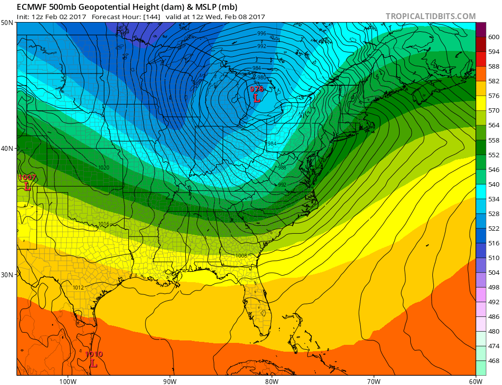
EUROPEAN MODEL MAJOR STORM GREAT LAKES WEDNESDAY FEBRUARY 8TH
There possibly be some lightning and thunder in the mix too as a strong cold front swings east from the storm and heads to the coast. However as far as snow is concerned this will depend on how fast it gets here Monday night when it still might be cold enough. Sometimes you can see a front end thump from systems like this but models have trended warmer ahead of it so I think at this point, the risk for that is not very high.
MAJOR STORM GREAT LAKES FORECAST SNOW MONDAY NIGH TUESDAY
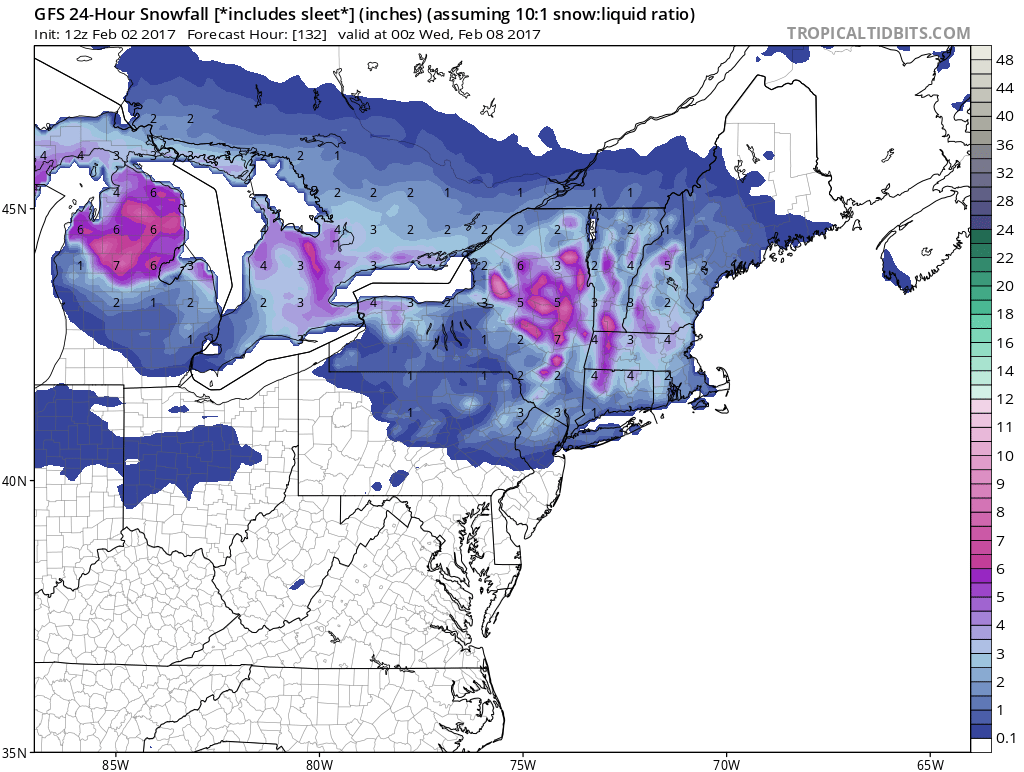
The new GFS weather model snow view has cut way back from earlier forecasts showing maybe a coating to a couple of inches Monday night into Tuesday morning before a change to rain. And it should be pointed out that the European and Canadian hold the precipitation back until Tuesday morning and show even less. The main emphasis will be on the rain and strong southerly winds that will develop later Tuesday night and on Wednesday.
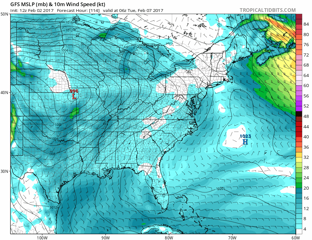
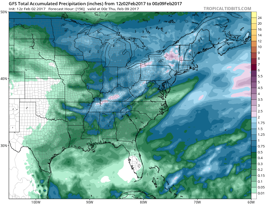
MAJOR STORM GFS MODEL TUESDAY THROUGH WEDNESDAY NIGHT
The GFS is showing sustained gales with this storm but the European is even stronger. Assuming we have a deep low moving to Toronto Canada like the European has, with the tight pressure gradient it could produce gusts over 50 mph in some areas along the coast. Early rain estimates would be in the 1 to 2 inch variety.
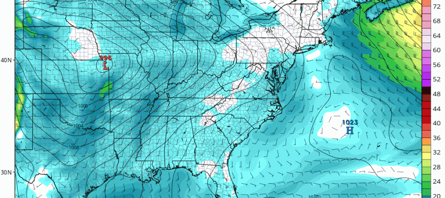
MAJOR STORM GFS RAINFALL FORECAST
At this point it seems to be a matter of fine tuning all this. The biggest question remains whether there will be some snow on the front end and whether the winds will be as strong as modeled by the European. We will continue to watch trends on model runs going forward and figure this all out. In the meantime other than colder temperatures the next few days, the weather remains uneventful through Sunday.
MANY THANKS TO TROPICAL TIDBITS FOR THE WONDERFUL USE OF THE MAPS
SNOW REMOVAL COMPANIES FOR YOUR WINTER NEEDS
LONG ISLAND ROCKLAND COUNTY Connecticut

![]()

ROCKLAND COUNTY TRI STATE SNOW REMOVAL JOHNSTOWN PA


FiOS1 News Weather Forecast For Long Island
FiOS1 News Weather Forecast For New Jersey
FiOS1 News Weather Forecast For Hudson Valley
NATIONAL WEATHER SERVICE SNOW FORECASTS
LATEST JOESTRADAMUS ON THE LONG RANGE
Weather App

Don’t be without Meteorologist Joe Cioffi’s weather app. It is really a meteorologist app because you get my forecasts and my analysis and not some automated computer generated forecast based on the GFS model. This is why your app forecast changes every 6 hours. It is model driven with no human input at all. It gives you an icon, a temperature and no insight whatsoever.
It is a complete weather app to suit your forecast needs. All the weather information you need is right on your phone. Android or I-phone, use it to keep track of all the latest weather information and forecasts. This weather app is also free of advertising so you don’t have to worry about security issues with your device. An accurate forecast and no worries that your device is being compromised.
Use it in conjunction with my website and my facebook and twitter and you have complete weather coverage of all the latest weather and the long range outlook. The website has been redone and upgraded. Its easy to use and everything is archived so you can see how well Joe does or doesn’t do when it comes to forecasts and outlooks.
Just click on the google play button or the apple store button on the sidebar for my app which is on My Weather Concierge. Download the app for free. Subscribe to my forecasts on an ad free environment for just 99 cents a month.
Get my forecasts in the palm of your hand for less than the cost of a cup of Joe!
![]()
