
Lower Temperatures Next 2 Days Dry Air Splits Region in Half
Labor Day Weekend Outlook

Lower Temperatures Next 2 Days Dry Air Splits Region in Half
Labor Day Weekend Outlook
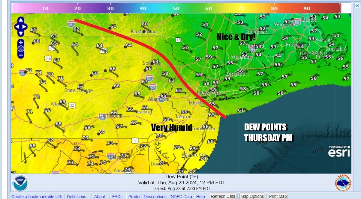
Today is going to be split in two as far as humidity conditions are concerned. The cold front that came through last night is edging slowly southward. Dry air is moving into Upstate NY and New England. It is bleeding southward but slowly. Areas generally from Northeast Pennsylvania, Northern New Jersey and points north and east will see dew points drop into the 50s. However for Central and South Jersey and the rest of Pennsylvania, dew points will remains stubbornly high.

At least as far as temperatures are concerned there is relief for everyone. Northeast to east winds will bring in cooler air off the ocean and from New England so high temperatures will be 20 degrees lower than Wednesday as highs everywhere will be mostly in the 70s. The onshore flow makes forecasting sky conditions a bit trickly. North and northeast of NYC we will see cloudy to partly sunny conditions developing while to the south in the area of high dew points, clouds will be an issue for much of the day. We will throw in the chance for a few widely scattered showers thanks to the onshore flow but no thunderstorms are in the forecast.
SATELLITE WITH LIGHTNING STRIKES

WEATHER RADAR

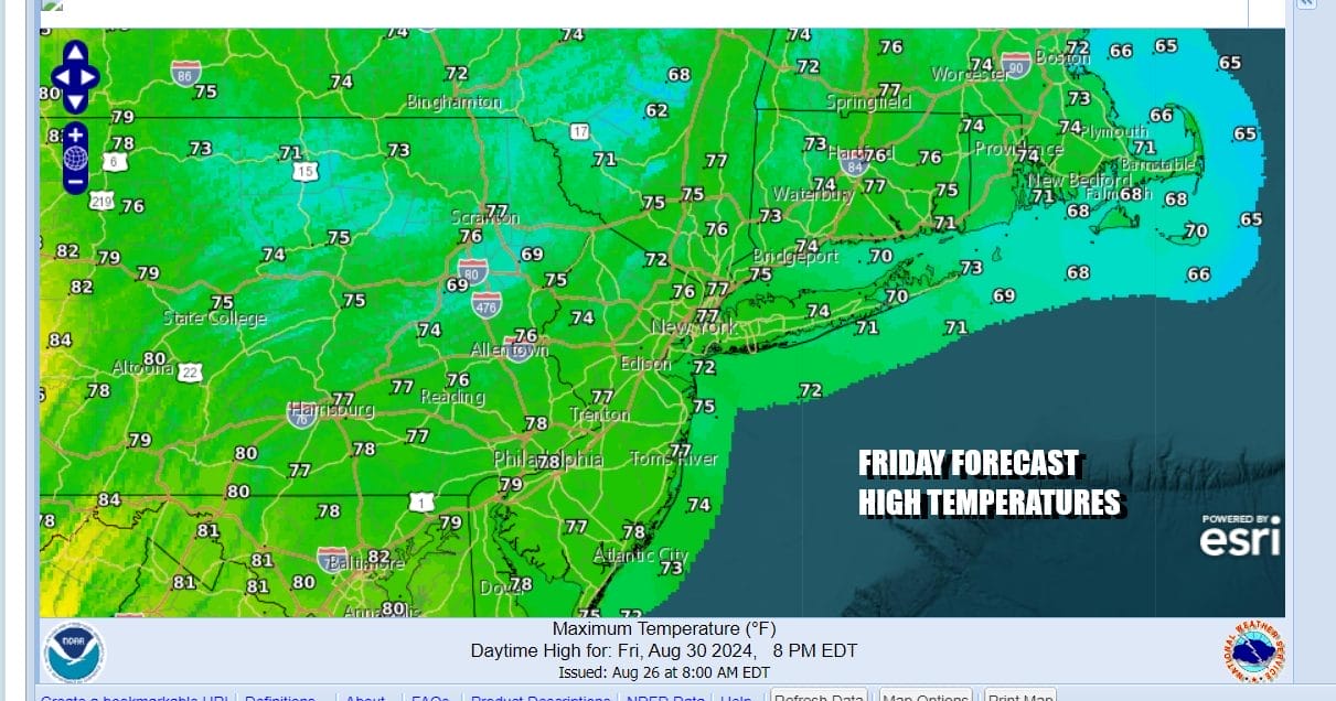
Night’s will feature low clouds and some patchy fog or drizzle with temperatures in the low to mid 60s. Friday we will describe as cloudy to partly sunny from southwest to northeast. If you are in Southern New England and Long Island and west of the Hudson River in New York you will see more sun and few clouds while to the west and south its the other way around. Temperatures Friday again will be in the 70s.
Over night into Saturday morning we will probably have low clouds & fog and perhaps a passing shower or two. Winds will be bending around to the south as high pressure in New England moves out to the east and a cold front begins to push in from the west out of the Ohio Valley and into Western Pennsylvania.
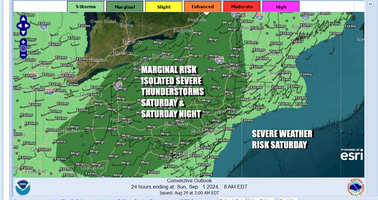
The Storm Prediction Center is indicating a marginal risk for severe weather Saturday with this approaching front however much of the dayside Saturday should be on the dry side. Some renegade pop up showers and thunderstorms could develop Saturday afternoon but the bulk of any shower or thunderstorm activity will come Saturday night. In the meantime temperatures rise somewhat and humidity rises. Highs Saturday will generally be in the upper 70s and lower 80s.

Showers and thunderstorms likely weaken as the near the coast and might even fall apart completely. This leads us to slowly improving weather conditions Sunday with decreasing clouds and increasing sunshine. Sunday highs will be in the 80s thanks to more of a west wind and more in the way of sunshine in the afternoon.
 Humidity levels will be slow to fall but Sunday night we will see dew points plunge leading us to what will be a very sunny, very dry, Monday which is of course Labor Day. Winds will be from the northwest as a large high pressure cell from Canada builds into the Great Lakes and northeast. Highs Monday will be mostly in the 70s.

September offers up an rather interesting pattern that has been sorely absent for the past 10 years or so. We have gotten used to extensions of summer well into September and sometimes early October. This September looks to have a northwest flow of air out of Canada which means dry air cooler air masses, short warm ups in between, cold fronts that come through and then are followed by another dry and cooler air mass. We will be talking about all of this on tonight’s Joe & Joe Weather Show which will be live at 7:35pm on Youtube.
BE SURE TO DOWNLOAD THE FREE METEOROLOGIST JOE CIOFFI WEATHER APP &
ANGRY BEN’S FREE WEATHER APP “THE ANGRY WEATHERMAN!
MANY THANKS TO TROPICAL TIDBITS FOR THE USE OF MAPS
Please note that with regards to any severe weather, tropical storms, or hurricanes, should a storm be threatening, please consult your local National Weather Service office or your local government officials about what action you should be taking to protect life and property.
(Amazon is an affilate of Meteorologist Joe Cioffi & earns commissions on sales.)


