Low Humidity Has Arrived Northeast Mid Atlantic
Next Front Delayed Until Thursday
Weather in 5/Joe & Joe Weather Show Latest Podcast
Low Humidity Has Arrived Northeast Mid Atlantic
Next Front Delayed Until Thursday
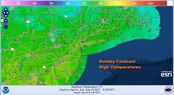
A cold front has passed offshore overnight and now we have dry air coming in on northerly winds aloft and at the surface. The satellite pictures and loops show mostly cloud free conditions in the Northeast and Northern Mid Atlantic states so we will enjoy a nice day of sunshine and low humidity. Highs today will reach the upper 70s to around or just over 80 with dew points down in the comfortable 50s. It is a nice way to finish off the weekend and finish off the last weekend of the summer season.
SATELLITE
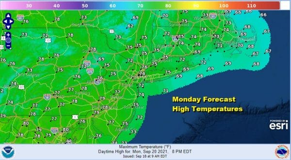
The are no issues on the radar to worry about probably into Wednesday so we will see clear skies tonight with most lows in the upper 50s to mid 60s. Monday looks nice and sunny with a northeast breeze and highs mostly in the 70s to near 80 degrees.
Sometimes tropical storms can have better weather implications for us when they are offshore as they strengthen the ridges of nice weather around them and that seems to be what is happening here. Peter will track well offshore next week but it helps us out in strengthening a high to our northeast. It also winds up slowing down the next cold front by a day.
We will hang on for 1 extra day as Tuesday should be partly sunny overall though there will be clouds around thanks to the flow coming in off the ocean and also it gradually turn more southerly over time. Humidity levels will start to rise Tuesday by a little and then more so Wednesday and Thursday. Tuesday highs will be in the 70s. Wednesday we will see more clouds around and a few scattered showers with temperatures in the 70s. Our cold front has now been pushed back to later Thursday and Thursday night with a round of rain as that goes by. Finally by Friday we start to see improvement and a return to lower humidity and cooler air in time for the first full weekend of Autumn.
BE SURE TO DOWNLOAD THE FREE METEOROLOGIST JOE CIOFFI WEATHER APP &
ANGRY BEN’S FREE WEATHER APP “THE ANGRY WEATHERMAN!
MANY THANKS TO TROPICAL TIDBITS & F5 WEATHER FOR THE USE OF MAPS
Please note that with regards to any severe weather, tropical storms, or hurricanes, should a storm be threatening, please consult your local National Weather Service office or your local government officials about what action you should be taking to protect life and property.


