
Low Heads Offshore Light Precip 60s Near Record Highs Saturday
Ahead of Next Cold Front

Weather in 5/Joe & Joe Weather Show Latest Podcast
Low Heads Offshore Light Precip 60s Near Record Highs Saturday
Ahead of Next Cold Front
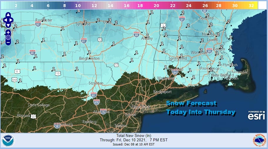
Our weather system offshore remains weak and is producing light precipitation along the immediate coastal plain. Most of it wasn’t even reaching the ground. We are seeing a little steady snow in Southeast Connecticut and points eastward. The snow forecast is minimal here with at most a coating to an inch or so. One more surge of snow on the radar in Upstate NY will pivot around this evening and that should be all gone by midnight. Temperatures are generally in the mid 30s to near 40 this afternoon and we will be down in the upper 20s to mid 30s for lows Thursday morning.
SATELLITE

WEATHER RADAR

We are going to see some sunshine on Thursday and since there isn’t any real cold air behind today’s storm system, temperatures should be able to rebound a little into the upper 30s and lower 40s. Warmer air coming up from the south will bring clouds Thursday night into Friday morning. There might be a couple of showers of rain or snow, mostly well inland as temperatures hold in the 30s overnight.

Friday we will see skies go from cloudy to occasionally partly sunny as a southwest flow develops and then that flow strengthens further Friday night and Saturday. Friday’s highs will be in the upper 40s and lower 50s and then temperatures hold at those levels at night. This sets us up for s very warm day Saturday with cloudy to partly sunny skies, breezy and warm conditions with highs in the 60s.
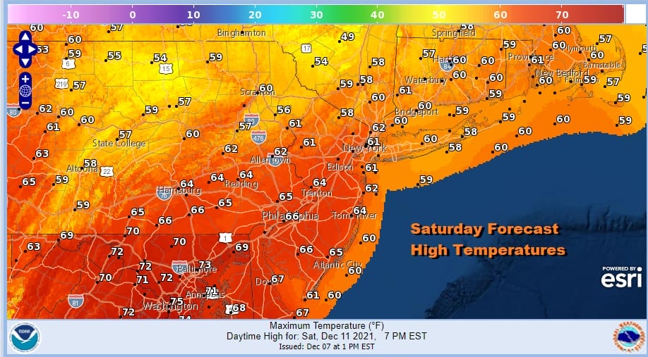
Late in the day the next cold front arrives with showers and some heavy downpours. The front passes offshore leaving us dry Sunday with colder and breezy conditions. Highs Sunday will be in the 40s. Next week will be a warm with week Highs starting in the 50s Monday and Tuesday and then perhaps going higher later in the week. Other than weak cold fronts we don’t see much in the way of rain next week and you can forget about snow altogether in this very warm pattern.
BE SURE TO DOWNLOAD THE FREE METEOROLOGIST JOE CIOFFI WEATHER APP &
ANGRY BEN’S FREE WEATHER APP “THE ANGRY WEATHERMAN!

MANY THANKS TO TROPICAL TIDBITS & F5 WEATHER FOR THE USE OF MAPS
Please note that with regards to any severe weather, tropical storms, or hurricanes, should a storm be threatening, please consult your local National Weather Service office or your local government officials about what action you should be taking to protect life and property.


