
LONG RANGE WEATHER PATTERN SHOWS NO CHANGE THIS WEEK

LONG RANGE WEATHER PATTERN SHOWS NO CHANGE THIS WEEK
If you are looking for a change in the overall pattern we have been in for the last 4 weeks, keep looking because the upper air jet stream does not favor invasions of cool Canadian air anytime soon. There will be some cooling thanks to an onshore flow that develops for mid and late week but in terms of something more long term in nature, we are not going to see it through this coming weekend.
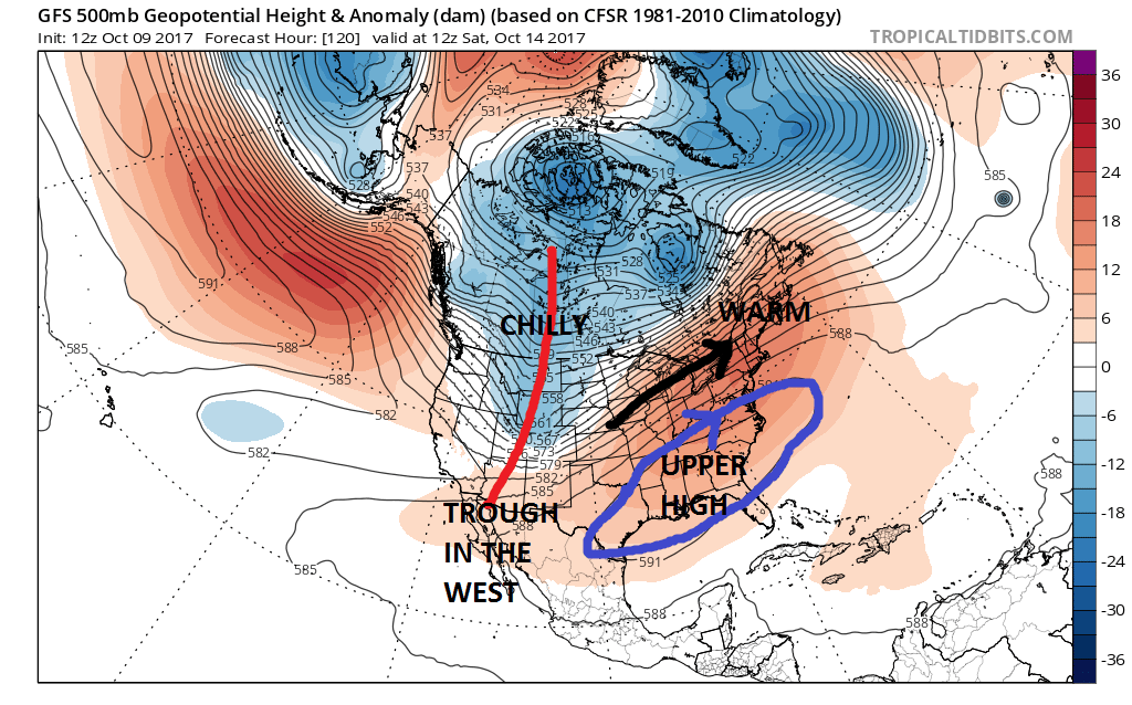
Anytime you see an upper air jet stream pattern like this, you can forget about colder air from Canada. There is an upper high in the Eastern US and an upper trough in the west. This has been the signature pattern since mid September. All the cold air is in the Rockies and Northwest. Canada is effectively shut off. If you follow the black arrow it is telling us that our air is coming from the southwest and the Southern Plains. This pattern also tends to be dry in nature so rain will be lacking. The only change this week is there will be a surface high building down from New England that will create an onshore flow (wind off the ocean) Wednesday through Friday which will put us in clouds and maybe some showers or some light rain or drizzle. From this temperatures at least for a few days won’t get out of the 60s. Then back comes the warm air for the weekend.

Even when we look out in the long range in days 11-12 which takes us to October 20-21, the ridge in the East is still there. The trough in the west is still there. The only cooling we will see is either if we get into an onshore flow from time to time, or we get cooling simply because the normals are dropping by a degree every 3 days. There are some differences in some model views as we get deeper into the long range however until we get some sort of wholesale change in Canada and a change in the position and strength of the ridge in the East, meaningful change in the upper air pattern will be hard to come by until late in the month.
CRUISE FANS SHOULD CHECK OUT AND LIKE THIS FACEBOOK PAGE
MANY THANKS TO TROPICAL TIDBITS FOR THE WONDERFUL USE OF THE MAPS

GET JOE A CIGAR IF YOU LIKE!
FiOS1 News Weather Forecast For Long Island
FiOS1 News Weather Forecast For New Jersey
FiOS1 News Weather Forecast For Hudson Valley
NATIONAL WEATHER SERVICE SNOW FORECASTS
LATEST JOESTRADAMUS ON THE LONG RANGE
Weather App

Don’t be without Meteorologist Joe Cioffi’s weather app. It is really a meteorologist app because you get my forecasts and my analysis and not some automated computer generated forecast based on the GFS model. This is why your app forecast changes every 6 hours. It is model driven with no human input at all. It gives you an icon, a temperature and no insight whatsoever.
It is a complete weather app to suit your forecast needs. All the weather information you need is right on your phone. Android or I-phone, use it to keep track of all the latest weather information and forecasts. This weather app is also free of advertising so you don’t have to worry about security issues with your device. An accurate forecast and no worries that your device is being compromised.
Use it in conjunction with my website and my facebook and twitter and you have complete weather coverage of all the latest weather and the long range outlook. The website has been redone and upgraded. Its easy to use and everything is archived so you can see how well Joe does or doesn’t do when it comes to forecasts and outlooks.
Just click on the google play button or the apple store button on the sidebar for my app which is on My Weather Concierge. Download the app for free. Subscribe to my forecasts on an ad free environment for just 99 cents a month.
Get my forecasts in the palm of your hand for less than the cost of a cup of Joe!