Long Range Cool Wet For First Half of May

Long Range Cool Wet For First Half of May
We have seen occasional days in the month of April where temperatures soared through the 80s. Yesterday was a perfect example of this. However as we head into May we are seeing a rather cool and potentially wet pattern setting up for the next few weeks across the Northeast & Middle Atlantic states. Blocking in the atmosphere is going to be the primary player over the next few weeks. The video above explains blocking and how it works. If you think about it. If you are travelling from point A to point B, a block would force you to take a detour which likely takes you longer to get to your destination. Often times the trip is rather unpleasant. This is what is happening in the atmosphere with the normal flow of the jet stream. Instead of a general west to east motion we are seeing the jet stream being displaced further south of normal.This creates a pathway for colder air from Canada and the North Atlantic to move into the Eastern states. It also opens the door up for a wetter than normal pattern under certain circumstances.
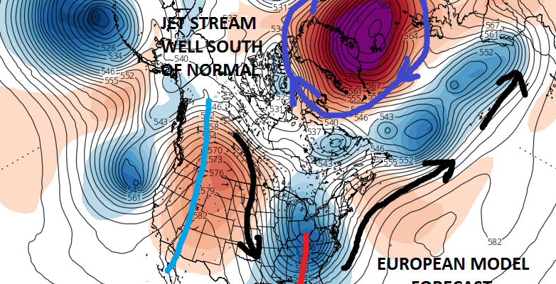
LONG RANGE EUROPEAN UPPER AIR FORECAST FRIDAY MORNING MAY 5TH

This is the upper air forecast from the European model for Friday morning May 5th 2017. Other weather models are about the same and identical in the general profile. The big blocking high sits locked away over Greenland. What this does is it displaces the entire jet stream well to the south of normal. A deep trough is in the west. Ocean storms in the Atlantic lie along 50 degrees north creating a strong westerly jet stream in the Atlantic north of 35 degrees north. In the west in response a strong ridge develops into Western Canada. In the winter this might be screaming major snowstorm for somebody. In May it shouts prolonged and a potentially heavy rain event for the Great Lakes Ohio Valley & the East late this week.
LONG RANGE GFS RAINFALL FORECAST THROUGH SATURDAY EVENING
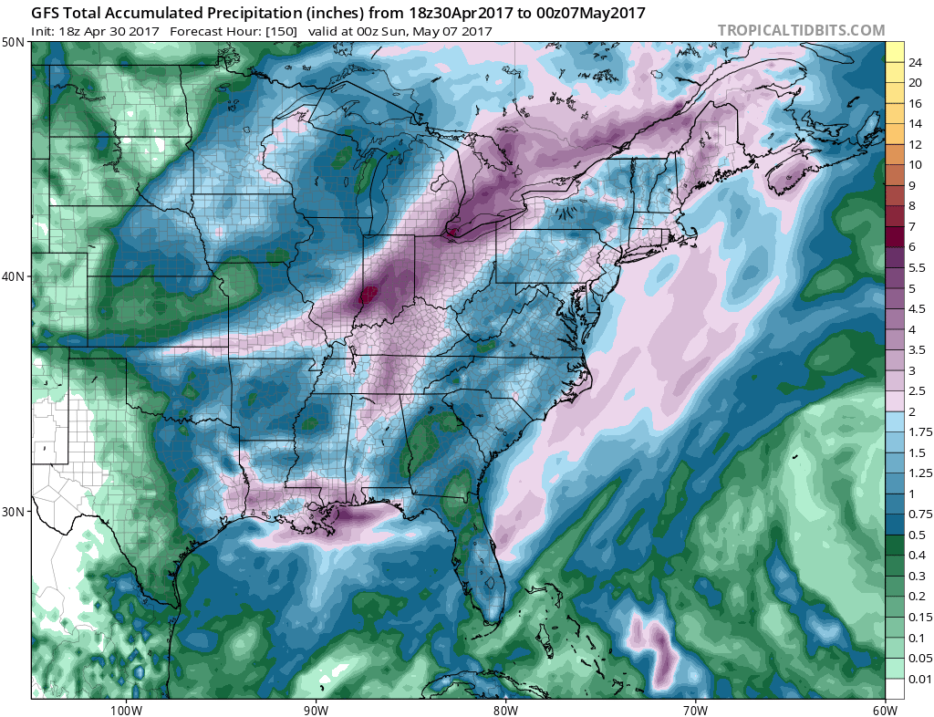
Early rainfall forecasts are in the 1 to 2 inch rain but this system does have potential to produce more depending on the track and speed of the surface and upper air storms. These are issues we will resolve in the coming days.
EUROPEAN MODEL UPPER AIR THURSDAY MAY 4TH-WEDNESDAY MAY 10TH

Going a little further into the long range into the middle of next week, the block has moved westward into Canada and we still have a strong jet stream presence well south of normal. This would certainly suggest cooler than normal temperatures until mid month with more chances for rain.
MANY THANKS TO TROPICAL TIDBITS FOR THE WONDERFUL USE OF THE MAPS

GET JOE A CIGAR IF YOU LIKE!
LANDSCAPE COMPANIES FOR YOUR SPRING SUMMER FALL NEEDS
LONG ISLAND ROCKLAND COUNTY Connecticut

![]()

ROCKLAND COUNTY TRI STATE SNOW REMOVAL JOHNSTOWN PA


FiOS1 News Weather Forecast For Long Island
FiOS1 News Weather Forecast For New Jersey
FiOS1 News Weather Forecast For Hudson Valley
NATIONAL WEATHER SERVICE SNOW FORECASTS
LATEST JOESTRADAMUS ON THE LONG RANGE
Weather App

Don’t be without Meteorologist Joe Cioffi’s weather app. It is really a meteorologist app because you get my forecasts and my analysis and not some automated computer generated forecast based on the GFS model. This is why your app forecast changes every 6 hours. It is model driven with no human input at all. It gives you an icon, a temperature and no insight whatsoever.
It is a complete weather app to suit your forecast needs. All the weather information you need is right on your phone. Android or I-phone, use it to keep track of all the latest weather information and forecasts. This weather app is also free of advertising so you don’t have to worry about security issues with your device. An accurate forecast and no worries that your device is being compromised.
Use it in conjunction with my website and my facebook and twitter and you have complete weather coverage of all the latest weather and the long range outlook. The website has been redone and upgraded. Its easy to use and everything is archived so you can see how well Joe does or doesn’t do when it comes to forecasts and outlooks.
Just click on the google play button or the apple store button on the sidebar for my app which is on My Weather Concierge. Download the app for free. Subscribe to my forecasts on an ad free environment for just 99 cents a month.
Get my forecasts in the palm of your hand for less than the cost of a cup of Joe!
![]()
