Long Island To Enjoy A Rare Nice Spring Weekend Sunday Highs in the 70s Inland
 USE COUPON CODE JOEANDJOEWEATHERSHOW GET 10 PERCENT OFF ANY PURCHASE

Long Island To Enjoy A Rare Nice Spring Weekend Sunday Highs in the 70s Inland
Nice weather in the spring on the weekend for Long Island doesn’t happen often but this weekend is going to be a good one overall. The blocking pattern has broken down and the stalled upper low over the Eastern US is now offshore and moving quickly away to the east. We still have one last upper trough moving through this afternoon and evening and while we did start with sunshine today, some clouds are developing. There is the chance for an isolated shower or two late this afternoon and evening but the chances aren’t high and even if it happens it won’t amount to much. Temperatures this afternoon will be in the upper 50s and lower 60s.
SATELLITE

WEATHER RADAR


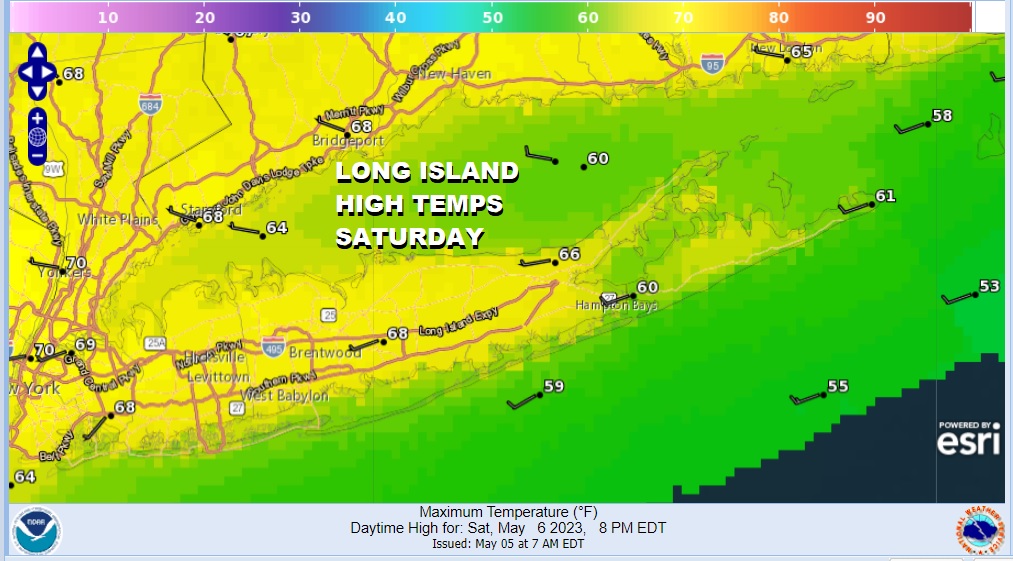
Once we get through the evening hours the atmosphere will stabilize and high pressure starts to build southward from Eastern Canada. Skies will clear tonight with most lows in the 40s. Saturday will be a nice day with sunshine. Temperatures will have a chance for some upside and most Long Island highs will reach 65 to 70 degrees. It might be just a little cooler along the immediate South Shore with local sea breezes.
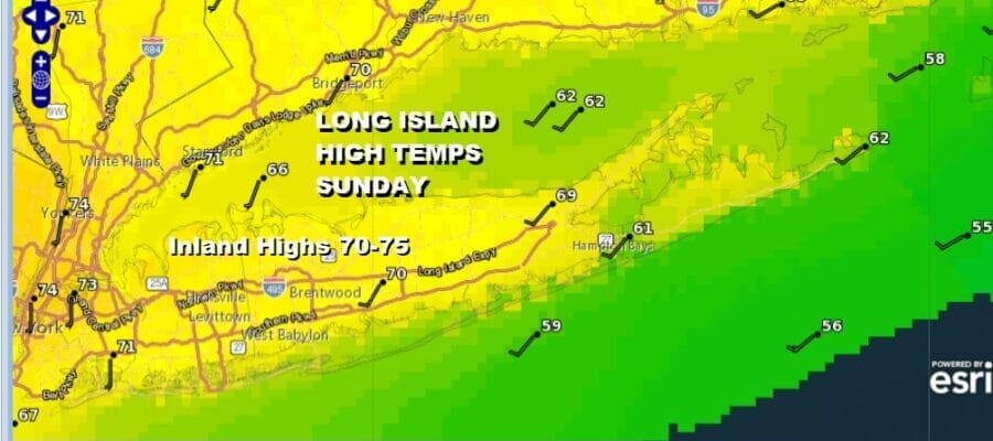
This building high will shield Long Island and the Northeast from rainy weather to west and south. Sunday should be a very good day and there is room for a little upside in temperatures. Sunshine should take highs to a range of 70 to 75. Again, local sea breezes will develop along the South Shore and East End and temperatures will be in the cooler 60s in those areas.

Sunday night into Monday morning we will see the first of two disturbances moving southeast from the Great Lakes and we could see some showers later Sunday night into Monday morning followed by a second disturbance with a chance for showers Monday night into Tuesday afternoon. In between we will see clouds and some sun Monday with highs into the 70s. There is no blocking so weather should improve for midweek.
BE SURE TO DOWNLOAD THE FREE METEOROLOGIST JOE CIOFFI WEATHER APP &
ANGRY BEN’S FREE WEATHER APP “THE ANGRY WEATHERMAN!
MANY THANKS TO TROPICAL TIDBITS & F5 WEATHER FOR THE USE OF MAPS
Please note that with regards to any severe weather, tropical storms, or hurricanes, should a storm be threatening, please consult your local National Weather Service office or your local government officials about what action you should be taking to protect life and property.