Long Island Thanksgiving Dry & Nice Followed By Cold Air For the Weekend
 USE COUPON CODE IWANTAWEATHERSTATION GET 10 PERCENT OFF ANY PURCHASE

Long Island Thanksgiving Dry & Nice Followed By Cold Air For the Weekend

The heavy rain of last night is all done and now we can move ahead to calmer weather over the next several days. No rain or snow is in the forecast for Long Island. Today is the big travel day and we see improving weather conditions with developing sunshine along with a few patchy clouds. It will start to become breezy later today with highs in the mid to upper 50s. Skies tonight should partially clear though it will be on the breezy side as low pressure develops offshore. Thursday morning lows will be in the 30s.
SATELLITE

WEATHER RADAR


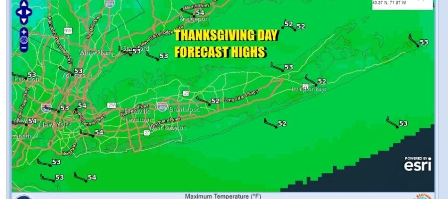
Thursday is Thanksgiving day and we see no weather issues for the day other than winds will be on the gusty side for much of the day. We have a storm developing well offshore and that will keep the pressure gradient on the tight side but winds won’t get too out of hand. Look for a mix of sun and clouds with highs in the lower 50s.

A weak cold front will move through Thursday night but it won’t have much with. It will turn the winds from west to northwest as a cold high drops southeast from Canada and spreads across the Great Lakes and the Eastern US. This leads to colder temperatures but the cold comes in slowly. Friday we will see sunshine with highs in the upper 40s. Then temperatures drop under clear skies and Saturday morning lows will be in the low to mid 20s.

Saturday will be the coldest day of the autumn season so far with sunshine but temperatures by day will not get out of the 30s. Saturday night into Sunday morning will be cold and clear with lows again in the 20s and some teens will occur in the coldest spots. Sunday look for sun and arriving clouds with highs back into the 40s. There are two week systems that might bring some showers Sunday night and that will be followed by another shot of cold air which will hang around for much of next week. No major storms are on the horizon for the time being.
BE SURE TO DOWNLOAD THE FREE METEOROLOGIST JOE CIOFFI WEATHER APP &
ANGRY BEN’S FREE WEATHER APP “THE ANGRY WEATHERMAN!
MANY THANKS TO TROPICAL TIDBITS FOR THE USE OF MAPS
Please note that with regards to any severe weather, tropical storms, or hurricanes, should a storm be threatening, please consult your local National Weather Service office or your local government officials about what action you should be taking to protect life and property.