Long Island Onshore Flow Cooler Temperatures Wednesday
Showers Late Thursday

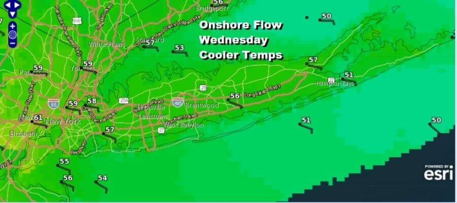
Tuesday was one of those rare days on Long Island in the spring where the wind behaved itself for the most part and temperatures in most areas inland reached the mid 60s to lower 70s. However that comes to an end as a backdoor cold front across Upstate NY moves southward tonight and settles south of Long Island Wednesday. This means we have curse of the onshore flow in effect for Wednesday with an east to southeast wind. Also we will likely see cloudy skies and there will be some drizzle around from time to time. All in all it is going to be a gloom and doom type of day. Temperatures will top in the lower 50s East End and middle 50s just about everywhere else.
SATELLITE

WEATHER RADAR


This front to the south will then back the other way and move northward Wednesday night and that will put is in a west southwest flow for Thursday. There will also be a cold front that will arrive late in the day. Ahead of it clouds may break for some sunshine especially in the western part of the island but it may be a tougher sell over the East End. High temperatures Thursday will have a wide range from the 50s on the East End. However to the west we could see highs reach the mid 60s to perhaps even 70 degrees.

The cold front will produce showers and possibly a thunderstorm as it goes by Thursday evening. Right now we lie just outside the marginal risk for severe weather that is being indicated for New Jersey by the Storm Prediction Center. Once the front passes we should see improving weather conditions and Friday through Sunday should see some sunshine each day. It will be cooler Friday with highs in the mid to upper 50s. Saturday will be a chilly day with highs just in the lower 50s. Easter Sunday looks nice with some sunshine and a south wind off the ocean so highs Sunday will be in the low to mid 50s.
BE SURE TO DOWNLOAD THE FREE METEOROLOGIST JOE CIOFFI WEATHER APP &
ANGRY BEN’S FREE WEATHER APP “THE ANGRY WEATHERMAN!
MANY THANKS TO TROPICAL TIDBITS & F5 WEATHER FOR THE USE OF MAPS
Please note that with regards to any severe weather, tropical storms, or hurricanes, should a storm be threatening, please consult your local National Weather Service office or your local government officials about what action you should be taking to protect life and property.